All this warm and wet weather may be coming to an abrupt halt as the NWS is indicating a much cooler air mass is headed out way. We may have some transitional rain and snow as the new air arrives but the forecast for the New Year is dry and chilly.
All of you up above a thousand feet should expect to see some white fluffy precipitation although the prognosticators are suggesting light amounts. Down here in the city maybe some white stuff, maybe not, possibly freezing rain later in the week, hard to say. I'll take snow over freezing rain anytime, anyplace, any day ;)

Musings about our Clark County weather
Saturday, December 27, 2014
Friday, December 19, 2014
If it Doesn't Get Cold Soon...
If it doesn't get cold soon, this could become the warmest December I have on record since 2002. We haven't had any record breaking heat, but it has been very warm overnight all month. The last time the mercury dropped below the freezing mark was way back on the 3rd of the month! I am running several degrees above normal both day and night thus far this month by the averages.
This is bordering on twilight zone crazy here ;)
The NWS and other weather prognosticators are suggesting a move toward more seasonal temps but unless we get a few really cold days before the New Year this could be the warmest December I have had yet at this location.
Stayed tuned and hey, while we have this warm weather you may as well soak it up, my friends; soak it up.
Saturday, December 13, 2014
Wild and Windy Again.
I lost a fence a few weeks ago to howling winds and now this latest storm took out another fence on the other side of yard. Grrr... I hate wind! We had some near record wind pass through the area a few days ago knocking out power to thousands and toppling countless trees. Gusts were exceeding 80 mph which is hurricane force. Even the sustained winds were tickling gale force for the better part of 8 hours. I have had enough wind for this season, let's just call it good, shall we!
Enjoy the holidays and now that the winds have subsided and the temps seem to be bordering on warm, go ahead and soak it up my friends, soak it up.
Enjoy the holidays and now that the winds have subsided and the temps seem to be bordering on warm, go ahead and soak it up my friends, soak it up.
Wednesday, December 10, 2014
Warm and Wet will Persist
Looks like this is going to remain a cozy warm December. I have been sitting quite balmy with temps in the mid to upper fifties. Nights are not much cooler dipping only into the forties. The rain is falling and the merry month of December may not yield any fluffy white precipitation this year. That makes some people really happy. Not me, I like it cold in the winter.
Things may chill out in a week or so in time for the Holidays, we shall see. In the mean time get out and soak it up my friends, soak it up!
Things may chill out in a week or so in time for the Holidays, we shall see. In the mean time get out and soak it up my friends, soak it up!
Monday, December 1, 2014
The Final Month of 2014 Commences!
 Wow, 2014 is just about gone. Crazy fast it went this year. Looking ahead I don't know what to think about the weather. We have had warm and cold in the last 30 days. There does not seem to be the proverbial weather harbinger this time around. We'll just have to wait and see.
November was about as spot on average as possible for temperatures. My 13 season average November low is 38.28 and my observed average low last month was 38.23. The 13 year average high is 50.31 and my observed average was 50.67. Like I said, spot on! precipitation was another tale altogether. My 13 season average is 7.98 inches and this year was a scant 3.08. Of the 5 "snow" months November has been the least likely to receive the fluffy white stuff. This time we got 1.1 inches of snow against the 13 season average of 0.49.
So the coldest temp was the 16th with a mark of 20.1. The warmest temperature was a balmy 61.3 on the 26th. The chilliest afternoon high came on the 13th with 36.8 and no surprise that was the day we got most of the month's snow. The warmest overnight low came on the 26th with a toasty July like 54.5 degrees.
We had but 2 days with rainfall exceeding 1/2 an inch. The wettest day a paltry 0.62 on the 21st. I recorded 8 subfreezing low temps.
What will this December bring? Will there be a white Christmas? Odds favor a no on that. Will it be wet? Cold, Warm? Who knows? Not me. It will be a great December and I wish you all a happy holiday season. Now get out and soak it up my friends; soak it up.
Tuesday, November 25, 2014
Balmy? November? A little, yes.
Temps will tickle 60 degrees by day and not much cooler by night as warmer southern air makes its way over the Pacific Northwest this week. We will see rain and showers through the Thanksgiving holiday and then we will likely return to a more seasonal cooler pattern.
Last weeks snowstorm was a bit of a letdown for snow lovers as the NWS prediction of 3-6 inches amounted to about an inch. East of the Cascades was a very different tale as Central Oregon got dumped on! Weather is a difficult thing to predict, even for the meteorologists.
Get an early start on your holiday shopping during this brief warm period and be sure to soak it up, my friends, soak it up.
Wednesday, November 12, 2014
Brrr... here is a little taste of winter.
Today will mark the first cold weather of the year. I woke up to upper twenties with a serious howling wind out of the east. The wind chill factor was likely in the single digits this morning. Our high temperature will probably be stuck in the thirties and then overnight or in the morning tomorrow a system will arrive bringing us either a really cold rain or a mix of frozen precipitation. This won't be a significant winter event, but it will remind us that the next several months are essentially wintertime. Bundle up, and soak it up my friends, soak it up.


Friday, November 7, 2014
Some Sunnyliciousness is coming...
Take a look at this forecast! Finally; we might see some sunshine. Doesn't that just break your heart? We have been in a rainy mess for weeks on end and now that proverbial light is shining at the end of the tunnel. Thankfully it is not the light of an oncoming train.

Soak it up my friends, soak it up.
Saturday, November 1, 2014
The 'Real' Autumn is Here
The second half of October was wet and wild. There was no shortage of rain and a couple of storms brought some serious winds along for the ride. But all that is so last month. While I am on the subject of last month here is the summary for October, 2014.
 October turned out to be a tad warmer than average and loaded with nearly double my monthly average of the wet stuff. A whooping 7.33 inches of rain ended up in my rain gauge in contrast to a typical 4.15 inches. The wettest day was the 22nd with 2.01 inches and that was one of three days exceeding an inch. October had 17 days with precipitation and 10 sunny days.
Temps ran quite a bit warmer than normal with my lows averaging 50.32 degrees five above and highs averaging 65.30 which is four above. The warm day was the 6th with an 80.7 degree mark just one tenth of a degree warmer than second warmest the day before. The coldest afternoon high came on the 24th with a 53.7 reading. The coldest temp of the month was a warm 43.1 on the 2nd. The warmest overnight temp came on the 18th with a 55.2.
This October is officially the first in my 13 years at this location not to record a sub 40 degree temperature. Hmm, cold winter ahead? Warm winter? Ah who knows? The fall color is a little flat but I think it may just be a little late this year. The trees on Green Mountain are starting to flash some color. We will see. Get out and Soak it up, my friends; soak it up.
October turned out to be a tad warmer than average and loaded with nearly double my monthly average of the wet stuff. A whooping 7.33 inches of rain ended up in my rain gauge in contrast to a typical 4.15 inches. The wettest day was the 22nd with 2.01 inches and that was one of three days exceeding an inch. October had 17 days with precipitation and 10 sunny days.Temps ran quite a bit warmer than normal with my lows averaging 50.32 degrees five above and highs averaging 65.30 which is four above. The warm day was the 6th with an 80.7 degree mark just one tenth of a degree warmer than second warmest the day before. The coldest afternoon high came on the 24th with a 53.7 reading. The coldest temp of the month was a warm 43.1 on the 2nd. The warmest overnight temp came on the 18th with a 55.2.
This October is officially the first in my 13 years at this location not to record a sub 40 degree temperature. Hmm, cold winter ahead? Warm winter? Ah who knows? The fall color is a little flat but I think it may just be a little late this year. The trees on Green Mountain are starting to flash some color. We will see. Get out and Soak it up, my friends; soak it up.
Monday, October 27, 2014
Wild Storm Packs Damaging Winds and Heavy Rain
 What a crazy storm that was this past weekend! This one packed some punch with gale-force winds and occasional monsoon-like downpours. I was watching some college football with my son and we heard a crash. Upon looking outside I realized that a 40 foot section of the fence between my yard and my neighbor had blown over. The strong wind snapped several of the 4x4 posts clean in half!
On Sunday I was working in my office upstairs and heard what sounded like a jetliner landing on my roof. I listened for a while then looked out the window to see rain coming down at a rate easily 4 inches an hour. I fumbled around with my camera phone and manged to get a recording of the tail end of this impressive cloudburst that included some pea sized hail.
My Facebook post read something like, "Apparently, summer is over." Yes, apparently it is. Soak it up my friends, Autumn is here and she is blowing a gale. Soak it up.
Wednesday, October 22, 2014
Big Scary Storm Headed our Way!
We have our first big storm of the season rolling in as we speak. This one is packing high winds that will really be felt along the coast. It is also tapping into some tropical moisture and that means we will get a good hard soaking.
The National Weather Service has a weather statement out on this. Be prepared for local street flooding as the drains are all clogged up fresh fallen leaves. My new rain gauge is acting up :( I have to go manual for a while :|
Batten down the hatches this could be a wet and wild ride!
The National Weather Service has a weather statement out on this. Be prepared for local street flooding as the drains are all clogged up fresh fallen leaves. My new rain gauge is acting up :( I have to go manual for a while :|
Batten down the hatches this could be a wet and wild ride!
Wednesday, October 1, 2014
So long September, Now the real Autumn begins
 October is here and the real autumn will step up and be noticed. September turned out to be a pretty warm month. I had average temps well above my 13 year normal. Overnight lows averaged nearly 54 degrees 2.5 above normal. Highs hovered just north of 77 degrees averaged over the month, that's 3 degrees above the established norm. The hottest day was the 6th when I measured 96.4 degrees and that was the third hottest day of the year. Speaking of hot, this past September recorded an impressive four days above 90 degrees. All told this year has delivered 11 days above the 90 mark. The coldest temp last month was a mild, 45.3 on the 4th. The coolest afternoon high came on the 29th when the merc topped out at 61.7. The warmest overnight low arrived on the 22nd with 61.1.
The month seemed to be rainy but really was about half of normal with my bucket collecting a mere 1.29 inches against my baker's dozen of years averaging 2.47. I had 9 days with something dripping in the rain gauge but only 6 days mustered more than trace. The wettest day was the 23rd with 0.61 inches.
October is a month that sees the Autumn plunge in full swing. Temperatures will plummet from an average high of 70 on the 1st to and average high of 52 on Halloween. The leaves are starting to flash a little color and the sun sinks fast in the west. Get ready to enjoy the brightest display of flora in the next few weeks.
Soak it up my friends, soak it up.
Tuesday, September 23, 2014
Welcome to Autumn!
 My friend and local weather guru, Pat Timm posted this satellite pic of the storm we have perched off the coast. This one is 'all coiled up an hissin' if you'll pardon the REO Speedwagon parlance. The rain has already started to fall on this very first day of fall. Soon the colors of Autumn will begin to flash like fireworks on the Fourth of July. Ah, just soak it up my friends, soak it up.
Saturday, September 20, 2014
90s as Summer's Final Few Days Wind Down
I hit 90 plus today and the autumnal equinox is less than three days away. This is probably the last heat wave of 2014 so I suggest you get out and soak it up my friends, soak it up.
Saturday, September 6, 2014
The heat is on!
Those East winds are blowing and bringing with them high temperatures. I very well may see the hottest day of the year today. It is 95 degrees already and it's only 12:30. I have yet to record triple digit heat this year but today could be the day. Hold on to your hats or the East wind will blow it off. Today is going to sizzle like bacon on a griddle. Ouch! Be careful out there; this is the kind of weather that can overwhelm you. Drink lots of fluids and stay out of the direct sunlight. Cover up and of course don't forget to soak it up my friends, soak it up :)
Monday, September 1, 2014
August is in the Books
August was indeed a warm month here in America's Vancouver. Both the overnight lows and daytime highs were well above the normal with observed averages of 58.6 and 82.41 respectively; each nearly three degrees above. This past august also brought with it the hottest day of the year thus far with a blistering 98.4 on the 11th. The chilliest afternoon was the 30th which was also the only day of the month that failed to reach 70 degrees topping out at just 68.7. There was only once instance where the mercury plunged below 50 degrees and that was the night of the 21st with a cool 49.2. The warmest overnight low was a balmy 66.9 on the 12th; a day that would deliver some thunder and lighting. This month produced 12 warm evenings with temperatures above 60 degrees all night long. There were four days with heat above 90 degrees.
 August proved to be a dry month and it will likley be the driest of the year with a paltry 0.27 inches in the rain gauge. Even the 12th with some strong down pours only managed to produce .07 inches. I wonder how much evaporated before the gauge could record it?
August was once again a fabulous month for weather here in the Pacific Northwest. Labor Day started off September with big bold sunshine and warm temps. September however typically proves to be warm at first then quickly cools as the month wears on. We shall see. Get out and soak it up my friends, soak it up.
August proved to be a dry month and it will likley be the driest of the year with a paltry 0.27 inches in the rain gauge. Even the 12th with some strong down pours only managed to produce .07 inches. I wonder how much evaporated before the gauge could record it?August was once again a fabulous month for weather here in the Pacific Northwest. Labor Day started off September with big bold sunshine and warm temps. September however typically proves to be warm at first then quickly cools as the month wears on. We shall see. Get out and soak it up my friends, soak it up.
Wednesday, August 27, 2014
The Waning days of Summer
This latest round of 90 degree weather may be our summer swan song. Temps are expected to drop 15 degrees or so over the next few days and we may even see a little wet stuff over the week end. September is a month that is generally quite pleasant. Sure we will have a little rain mixed in with sunshine. But the real indicator that change is eminent is felt in those cooler September nights. Enjoy the last of August and as I always say, soak it up my friends; soak it up.
Sunday, August 17, 2014
Heavenly
Yeah, that's about the size of it these past few days. Just perfect warm but not hot summer weather. This is why we endure the dark and gloomy winter :) Soak it up my friends, soak it up.
Monday, August 11, 2014
Absolute Steambath Today
It was a steamy day in the 'Couv' today with temps close to a hundred degrees and humidity working to poach us like an egg. My weather station reported a high of 98.4 degrees and humidity that hovered in the 50% range all day. It was a three shower day, eh? Fortunately this Houston, Texas impersonation is rare here in the Northwest and we should be back to normal by Wednesday. Soak it up my friends, soak it up :)
Saturday, August 9, 2014
Summerlicious just keeps on delivering!
The weather continues to live up to the delicious standards of the Pacific Northwest. My wife and I enjoyed some time up in the San Juan Islands last week and the weather was fabulous there as well. Temps ran a bit cooler in the way north but still nice warm 70s.
Locally we continue to enjoy temps hovering in and around 80 degrees by day and mid fifties by night and that is just heavenly.
Things are quickly going to change according to the national Weather Service in Portland. The heat will come with a fury starting tomorrow and into Monday. Then some moisture will arrive and the setup up for thunderstorms will be ripe later in the week.

Soak it up my friends, soak it up :)
Locally we continue to enjoy temps hovering in and around 80 degrees by day and mid fifties by night and that is just heavenly.
Things are quickly going to change according to the national Weather Service in Portland. The heat will come with a fury starting tomorrow and into Monday. Then some moisture will arrive and the setup up for thunderstorms will be ripe later in the week.
Soak it up my friends, soak it up :)
Friday, August 1, 2014
Warm and Toasty July
The month of July is in the books and the month of August began with a thunderstorm this morning that brought big bolts of lightning and some good old fashioned window rattlin' thunder.
We are smack dab in the middle of the dog days of summer and the weather is performing a masterpiece. As for July we had a pretty average month. Over all the temps both low and high were about two degrees above my 13 year average with 57.83 and 81.59 respectively. The hottest day of the month was the 1st with a toasty 96.9 which happens to be the hottest of the year thus far. The warmest overnight low was 62.2 on the 7th. The chilliest day was the 23rd with rain and a cool 61.7 for the high. The chilliest overnight low came in at a nippy 50.7 just eight tenths of a degree from the 40s. We had just 3 days in July above 90 but a whole slew of gorgeous 80s that add up to half the month.
On the rain side of things it was almost spot on my 13 year average for rain with 1.01 in the bucket just one hundredth of an inch off the average. All of the rain came in a short 48 hour window beginning on the 22nd and ending early on the 24th.
Overall that was a spectacular July and let's hope we get a repeat in August!
Wednesday, July 23, 2014
A Little Crackle, Boom and Splash
Oh the monotony of summer with those endless days of gorgeous sunshine and comfortably warm temperatures. We needed a little break didn't we? Well we got that to be certain. Yesterday I had 0.47 inches of rain in the bucket and today I had 0.51. That is nearly an inch in the last 36 hours! All that splash was accompanied by the boom and crackle of good 'ole thunder and lightning. ell we hit our average for the month so we should be done, right? Right! The temps were nice and cozy in the upper sixties and low seventies. But that will change here for the last weekend in July. It will be back to those monotonous boring perfect summer days... ho hum ;)
Soak it up my friends, soak it up.
Soak it up my friends, soak it up.
Wednesday, July 16, 2014
Another sunny and warm day... ho hum... ;)
 Summers in the 'Couv' are awesome. Sweet mother of the solar system, look at that sunshiny, golden goodness out there. Ok so it's a security cam picture, so what it still awesome out there :)
We should get more of this through Saturday afternoon but just a tad cooler maybe around 80 degrees. Then chance of summer showers then more sunny yummies after that.
Soak it up my friends, soak it up!
Sunday, July 13, 2014
Fabulous warm weather will continue!
Yes it will. But today we are going to have a brief departure from the saucy sunshine and experience some summer thunderstorms. The rumble and boom of mother nature will remind us that the Pacific Northwest is not immune to a little violence in the atmosphere. Hug your pets and batten down the hatches, this will be a brief but bumpy ride this afternoon.
The rest of the week looks like more yummy summerliciousness. I invented a new word. Soak it up my friends, soak it up.
The rest of the week looks like more yummy summerliciousness. I invented a new word. Soak it up my friends, soak it up.
Wednesday, July 9, 2014
Summerlicious!
Fabulous summer weather continues with 80s all around. That big yellow orb is taking its sweet time as it dances across the sky for 16 hours before offering a long twilight glow to match our warm summer evenings. it is summerlicious!

Tuesday, July 1, 2014
June is gone and Hello Hot July
 The month of June is in the books and it was par for the course. Rain was a touch on the light side and temps were spot on for my 13 year average.
We had just two days with a temperature at 80 degrees or more and a total of only eight hours of eighties. The warmest temp was on the last day of the month with a nice 82.9 degrees. The warmest overnight low came on the evening of the 26th with a comfortable 58.8. The coldest temp came on the 5th with a chilly 45.1 and the coolest afternoon high was a moderate 56.4 on the 17th. we had 15 days with temps in the 70s including eleven in a row from the 1st to the 11th
The rain gauge picked up 1.96 inches for the month roughly a 1/2 inch lower than "normal". The wettest day was the 26th when 0.64 inches fell.
Overall June was pretty uneventful on the weather front. July however has other ideas. My weather station was seriously flirting with 97 degrees today. I had 96.9 this afternoon. What the heck is that all about? The east winds blew on and off and that brought the dry heat from the other side of the Cascades. Don't forget that the center part of the "Evergreen State" is actually a desert!
Looking ahead to the all important 4th of July weekend it looks like a nice warm and dry experience this year :)

That look s real nice... soak it up my friends, soak it up!
Saturday, June 28, 2014
Come out summer, it's time to come out...
What a wild and wet week this has been. The weather has had a bit of a tropical flavor with warm rain and peek-a-boo sunshine. The national Weather Service in Portland is calling for warm and sunny starting early next week and extending towards the 4th of July Holiday. Eighties, baby, 80s :)

Yes you saw that right, so get ready to soak it up my friends, soak it up.
Sunday, June 22, 2014
Summertime is here...probably.
Yesterday was the summer solstice. The longest day of the year here in the northern hemisphere. Isn't that warm twilight sky awesome at 10 o'clock? Yes it is. The Pacific Northwest region can't get too excited about summer until the booms and bangs of Independence day are through. It isn't until Uncle Sam's birthday arrives that summertime is really secured. But my how that summer is so sweet. 75 glorious days of sunshine and warm temps with a light that lingers well into the late evening.
The solstice turned out to be quite nice after the clouds cleared out in the afternoon. I had a nice, comfy mid to upper 70s under brilliant sunshine. Hello summer. get out and soak that up my friends, soak it up.
The solstice turned out to be quite nice after the clouds cleared out in the afternoon. I had a nice, comfy mid to upper 70s under brilliant sunshine. Hello summer. get out and soak that up my friends, soak it up.
Monday, June 16, 2014
Warm dry and soggy too So goes June in the 'Couv'
Our neighbors south of the Columbia enjoyed nice summery weather for the Rose Festival which seems to be a rarity. The Rose Festival low as it is affectionately called, was delayed this year. But fickle spring was not to be denied her angry bouts of wet temper. This whole last week was a cloudy display of drips and raging downpours.
I have openly pondered the notion that perhaps this year we will have a summer that actually gets underway in June. Some weather experts seem to think that an extended period of warm and dry weather is eminent. I don't know too many people that would not welcome an early summer.
Whatever the weather get out and soak it up my friends, soak it up.
Saturday, June 7, 2014
What a great start to June.
We have had a bit of cloudiness from about 8am till noon every day this first week of June. We have been blessed with fantastic sunshine and 70s all week though. This is heavenly weather. The forecast from the gang at the NWS Portland are suggesting more of the same for the next few days. Later in the coming week we may see some showers but pleasant all around. Amen and soak it up my friends, soak it up :)

Monday, June 2, 2014
June is Here :)
Wow it is actually June. I love June. June marks the beginning of those ridiculously long summer nights. The Summer Solstice is upon us with an arrival in just about three weeks. Nearly 16 hours of sunshiny goodness and at least 4 more hours of beautiful twilight. If you are an astronomy buff this is the sucky time ;) We only manage to get about 3.5 hours of astronomical dark sky. You need to be observing from 11:30 pm to 3:00 am. Yikes!
It's worth it though. Summer is on its way and I am excited about it. But before I jump up and down with glee that the rains will begin to subside and the sun will warm us into glorious 80s... let's take a peek at the numbers for a very bouncy May.
 May opened up with the first 90 degree temp of the year on the 1st of the month with a 90.1 degree reading. That was not enough to top the chart for the whole month as the 14th mustered up a toasty 90.3 degrees. Average highs across the whole of May were 69.28 degrees quite warmer than the "normal" 66.56. In fact the merry month of May produced five days above 80 degrees and another six in the 70s. The chilliest daytime high was on the 9th with a 53.2 degree reading under heavy rain and hail. But we can't complain since 26 of May's 31 days managed to get above 60 degrees.
May was also a bit balmy overnight this year. Average low temps were 49.43 degrees about 3 above the normal 46.77. The coldest low temp came on the 7th with an April-ish 39.7 degrees. Some of the outlying areas got a little frost that day, not here though. The warmest night of the month came on the 23rd with a very July-like 57.3 degrees.
Precipitation was close to normal. My rain gauge is out of commission so I used the numbers from the "Orchards North" station, very nearby. I think I actually got a little more rain than showing on the chart but it is close. 3.20 inches of wet stuff and a couple of days with a thick coating of hail on the ground. We had some bumpy T-storms rumble through a few times this past month. The wettest day was a sloppy 1.17 inches. There were 5 days with more than quarter inch of rain and 16 days of delicious sunshine.
The forecast is for 70s and even a few 80s over the next week and so Portland's Rose festival should be just peachy. Get out and soak it up my friends, soak it up!
It's worth it though. Summer is on its way and I am excited about it. But before I jump up and down with glee that the rains will begin to subside and the sun will warm us into glorious 80s... let's take a peek at the numbers for a very bouncy May.
May opened up with the first 90 degree temp of the year on the 1st of the month with a 90.1 degree reading. That was not enough to top the chart for the whole month as the 14th mustered up a toasty 90.3 degrees. Average highs across the whole of May were 69.28 degrees quite warmer than the "normal" 66.56. In fact the merry month of May produced five days above 80 degrees and another six in the 70s. The chilliest daytime high was on the 9th with a 53.2 degree reading under heavy rain and hail. But we can't complain since 26 of May's 31 days managed to get above 60 degrees.May was also a bit balmy overnight this year. Average low temps were 49.43 degrees about 3 above the normal 46.77. The coldest low temp came on the 7th with an April-ish 39.7 degrees. Some of the outlying areas got a little frost that day, not here though. The warmest night of the month came on the 23rd with a very July-like 57.3 degrees.
Precipitation was close to normal. My rain gauge is out of commission so I used the numbers from the "Orchards North" station, very nearby. I think I actually got a little more rain than showing on the chart but it is close. 3.20 inches of wet stuff and a couple of days with a thick coating of hail on the ground. We had some bumpy T-storms rumble through a few times this past month. The wettest day was a sloppy 1.17 inches. There were 5 days with more than quarter inch of rain and 16 days of delicious sunshine.
The forecast is for 70s and even a few 80s over the next week and so Portland's Rose festival should be just peachy. Get out and soak it up my friends, soak it up!
Wednesday, May 28, 2014
May has been... well... May
It has been a roller coaster ride so far this month with the hottest temps of the year and some pretty big thunderstorms. We keep bouncing between warm and cool weather and that is pretty much par for the course in the merry month of May.
For Memorial Day the forecast warned of showers and that is also typical. But the weather man was off by a day as the holiday was mostly sunny and quite pleasant. I managed to get the BBQ out and soak up a nice mild afternoon :) Enjoy the rest of the week I chat next week with May stats.
For Memorial Day the forecast warned of showers and that is also typical. But the weather man was off by a day as the holiday was mostly sunny and quite pleasant. I managed to get the BBQ out and soak up a nice mild afternoon :) Enjoy the rest of the week I chat next week with May stats.
Wednesday, May 14, 2014
Hotter than the 4th of July? Probably
 We have another heat wave under way and the mercury has busted through to the nineties again! I average only 9 days a year at or above 90 degrees and now there is already two in the books this year! I am sitting at 90 degrees and watching all that delicious sunny goodness pouring all over the city.
So get out and soak it up my friends, soak it up!
Wednesday, May 7, 2014
Glorious Sunshine Returns
With nary a complaint from anyone, the spring weather has returned to the brighter and warmer variety we all know and love. Today's high temps were flirting affectionately with 70 degrees and the prognosticators at the NWS think it could be warmer over the weekend.
But first we must endure some more liquid refreshment. Showers abound till Saturday followed by a healthy dose of vitamin D enriching sunshine on Mother's Day.
Soak it up my friends; soak it up.
But first we must endure some more liquid refreshment. Showers abound till Saturday followed by a healthy dose of vitamin D enriching sunshine on Mother's Day.
Soak it up my friends; soak it up.
Thursday, May 1, 2014
April was a nice spring roller coaster ride!
 I am typing this at the noon hour with a balmy 83 degrees showing on the thermometer. The weather boffins at the National Weather Service seem to think we will punch through to 90 degrees as the day wears on. 90 degrees, quick Robin, activate the remote Bat swimming pool! Yeah it's kind of like that.
Yesterday was the warmest day of the year thus far (today will top it). I measured a toasty 84.7 degrees under gloriously sunny skies and nice breeze. Yesterday was in fact the warmest April day I have ever recorded at this location; my daily temp records date back to 2002.
The numbers for April were a touch warmer than average with the average daily high temp two above at 61.5 degrees and the average daily overnight low also two above at 43.2 degrees. The warmest overnight low was also yesterday with a June-like 50.5 degrees. After April fools day we managed to hit at least 50 degrees on every single day, April Fools manged a 49.6 as the coolest day of the month. We also managed to get through April with nary a freezing mark as the coldest low temperature was 36.5 degrees on the 13th.
It seemed like we got a fair amount of rain but the gauge showed a drier than average 3.66 inches of all rain. There were numerous days with scattered thunderstorms,so I would imagine that some gauges may show an inch more than others. The wettest day was 0.87 inches on the 23rd. Overall we had 11 'sunnylicious' days and 14 days with rain.
Now we march forward with summer feeling near. May opens with a summer sonata of upper eighties and maybe the first 90 of the year. 90 this early? Holy heatwaves Batman!
The NWS issued a heat warning. although these temps are not considered "hot" by summer standards, they are near record temps for this time of year and they are concerned with a lack of acclimation to the warmth affecting people. Also they warned that the temptation to jump into a local river is unwise as the water is flowing very fast and the water temps are bitter cold as this is snow melt friends. snow is cold ;) Be careful and use that noggin to make safe decisions but by all means; get outside and soak it up my friends, soak it up.
Wednesday, April 30, 2014
Spring has Some Sizzle, Sometimes
Well, someone told Miss Spring she's not hot... and that just pissed her off. Yesterday was gorgeous with temps in the 70s. Today and tomorrow however, are going to roast us to toast, just like July. Forecasts are pointing to a possibility of reaching not just 80 degrees but even 90 degrees on Thursday. I am not so certain about hitting ninety, but it will be warm for sure. I don't think you need a cue from me at this point but... Soak it up my friends, soak it up.
Saturday, April 26, 2014
Rain, rain, rain, and some sun too...
Oh spring you feisty little one... Temps on a yo-yo with wet and wild episodes and outbursts.
Friday, April 18, 2014
Fickle Spring Continues to be Erratic
Ah, springtime and a tickle of fickle. The last couple of days were cool and showery with a few heavy showers thrown in just to reminds us that we are west of the Cascades in the great Pacific Northwest. Today however El Sol will make an appearance and we should be much warmer and drier heading into Easter weekend.

I am not buying today's forecast since the sun is already bustin' through the cloud cover. But Easter Sunday should prove to be a gentle spring day. Soak it up my friends; soak it up.
Saturday, April 12, 2014
Sensational Spring Weather Continues
 It just keeps coming... more and more spring sunshine. I took a drive out to Yacolt today under mostly sunny skies and temps in the mid 60s. The East Fork of the Lewis River is flowing quite nicely. I pulled off the road and scampered down along the river bank to get this sloppy hand held waterfall shot.
The gang over at the National weather Service is suggesting we should see more sunshine and even warmer temperatures before the showers of Miss Spring return in the middle of the week. So you know what to do; soak it up my friends, soak it up.

Wednesday, April 9, 2014
Glorious Sunshine!
What a great day we had today and more of the same for the next few days :) 'nuff said.
Sunday, April 6, 2014
All Quiet on the Weather Front
There really isn't much to write about on the weather side of life. We are having a fairly typical and bland early spring with rain and showers, modest temps and peek-a-boo sunshine.
There is a silver lining in those dark clouds and the NWS seems to think it will shine upon us tomorrow with mid-seventies and beaming rays of glorious sunshine. Yeah, I will be soaking that up my friends... Soak it up.

There is a silver lining in those dark clouds and the NWS seems to think it will shine upon us tomorrow with mid-seventies and beaming rays of glorious sunshine. Yeah, I will be soaking that up my friends... Soak it up.
Wednesday, April 2, 2014
March is Gone, Hello April
 The Merry Month of March is in the books and the only real madness we had was the kind we like... in the NCAA Basketball Tournament. This March can be summed up in a word; "wet".
The rain bucket soaked up seven and a half inches of wild and wet precipitation. There were thunderstorms and some hail but nary a flake of snow down here in the city. The wettest day was the 5th with a whooping 1.14 inches coming down. There were 12 days with more than a quarter inch of rain and 20 days with measurable precipitation.
Temps for last month were pretty typical for March. Average lows at 39.13 which is a touch warm and daily highs averaging 56.06 two degree above average. The chilliest low was a nippy 29.1 on March 22nd and the warmest mark a sunshiny 71.4 which occurred on the 24th. That was the first 70 mark since October 22nd, and it felt GREAT. The first day of March managed a high of only 42.6 and that was the chilliest high temp of the month. On the 9th the mercury stayed above 50 with a low temp of 50.5 that was the warmest low of the month. The entire month only yielded 4 days with a subfreezing mark and 8 days with the high temperature reaching at least 60 degrees.
Other than the soggy otter effect of 7.47 inches of rain, March was pretty nice. April is allot like March just a tad warmer as we move away from the clutches of winter and into the fickle spring.
Soak it up my friends, soak it up.
Saturday, March 29, 2014
Epic Spring Cloudbursts Today!
Well Miss Spring had a bit of a vernal tissy today with copious sums of rain crashing down upon us throughout the day and a little thunder and hail just to let winter know, she is in control.
Over all the incidents of heavy rain were scattered but holy cow did it come down in some spots today!
The forecast for the next few days is more of the same and again the NWS is optimistic with these forecast temps in the mid to upper fifties. It has been more like upper 40's and low fifties so we shall just have to wait and see if Miss Spring can rip the controls for the atmosphere away from the clutches of Old man Winter once and for all as the month of April looms on the near horizon.

As usual rain or shine, sun or snow, soak it up my friends, soak it up.
Over all the incidents of heavy rain were scattered but holy cow did it come down in some spots today!
The forecast for the next few days is more of the same and again the NWS is optimistic with these forecast temps in the mid to upper fifties. It has been more like upper 40's and low fifties so we shall just have to wait and see if Miss Spring can rip the controls for the atmosphere away from the clutches of Old man Winter once and for all as the month of April looms on the near horizon.
As usual rain or shine, sun or snow, soak it up my friends, soak it up.
Wednesday, March 26, 2014
Spring Rain Washes Away the Flowers

 |
| Wiki-commons image |
Soak it up my friends, soak it up.
Sunday, March 23, 2014
70 degrees? Could be...
The great yellow orb has been blessing us with her brilliant presence in the post equinox sky. Spring, oh, glorious spring. Today and tomorrow is expected to yield the warmest temperatures of the season with the National Weather Service anticipating a 70 degree mark tomorrow afternoon. Some showery weather will return to the area later in the week and that precipitation should be welcomed with open arms as the annual rain bucket is still a little dry.
In the mean time, get outside and soak it up my friends, soak it up.

In the mean time, get outside and soak it up my friends, soak it up.
Wednesday, March 19, 2014
The Eve of the Vernal Equinox has Arrived
 |
| Wikipedia image |
Anchorage and Honolulu will each share a day of twelve hours and a night of the same. But only twice a year does this phenomenon happen. Here in the 'Couv' and in all points north of the equator we shall begin our march toward the summer. Our days shall increase and our nights shall decrease. For those of us above the 45th parallel we begin our race to the Solstice. It is a race we always win over our warmer and more southerly friends. Further and further ahead we run until the 21st of June when the southerners will begin their chase to the Autumnal Equinox.
Here in the Great Northwest we endure the long dark nights and the short gloomy days with that incessant drip, drip, drip from the heavens. But now the those nights will start to shrink and the sun will continue its climb up higher into the sky. More and more El Sol will come out and play. Warmer and warmer we shall become. Tomorrow it is springtime and that of course is a good thing.
 |
| globalmaps.com |
Smile my northern latitude friends, for this is our time to shine. By the solstice in June, Anchorage will have 17 hours and 22 minutes of sunshine while Honolulu will only have 13 hours and 26 minutes. Here in America's Vancouver we will enjoy a nice 15 hours and 43 minutes of sunshine on the summer solstice. It all begins tomorrow at 4:58 AM. Springtime is finally here. Each new day will add a minute or two to a daylight. It just keeps getting better.
Soak it up my friends, soak it up.
Saturday, March 15, 2014
Winter is losing its Grip, Spring is in the Air
Yet another fabulous day with El Sol shining proudly in the sky is beginning to materialize. Yesterday, I actually pulled out the trusty lawnmower after its four month slumber in the garage. Winter is losing its grip on us and Spring is truly in the air. That said, old man winter may still get a few swipes in before he gives way to flowers, warm sunshine, and gentle showers.
I have seen snow fall in April, mind you it doesn't stick around but for a few minutes or maybe an hour. But the chill of winter can reach even into the month of May at times. This year has been a strange one however. We had substantially more than average snowfall down near sea-level, but the might Cascade mountains are running quite low on snow. Even today a glance up at the foothills shows nary a sign of the white wintry scenes and only the tippy-top of Silver Star has any snow at all. That is quite unusual indeed.
Maybe we will have an early spring after all? While we wonder about the plight of the near future, I say get out and enjoy this delicious weather; you know... soak it up, my friends, soak it up.
Wednesday, March 12, 2014
OH Gloriously Warm Rays, Beam Down Your Sunny Goodness

But this afternoon the mercury soared well into the 60s with my station reporting a balmy 63.9 degrees just a little earlier.
March loves to tease and this March is no different. The forecast from the NWS shows a typical pattern and that this glorious sunshine will go away again yielding to our necessary rain showers.

March is month of sun and rain and sometimes even a little snow. What will this March bring us between now and the Equinox? Yes, the Vernal Equinox is less than 10 days away. The daylight hours stretch on longer and the warmer temps have brought my lawn out of its winter slumber. I need to prep the mower for its first outing of the season. Ah, springtime in the 'Couv' is coming soon. Soak it up my friends, soak it up :)
Saturday, March 8, 2014
Rain, Rain, Rain, We need it.
We had a touch of golden sunny goodness yesterday but the last several weeks have been a constant drip of rain. But we do need the rain and so we all need to suck it up and enjoy the moisture. Temps have been in the balmy upper fifties by day and not much cooler by night. Soak it up my friends warm weather will be here soon. Soak it up.
Monday, March 3, 2014
And There It Is :)

The sun is out, albeit temporarily, but this is a sign of spring. Remember, march is fickle, very fickle so be sure to... soak it up, my friends, soak it up.
Saturday, March 1, 2014
A Fickle February is Done
February 2014 has gone down as a mixed bag of goods. The month started out very chilly with the 6th recording the coldest daytime high reading since January 4th, 2004. The month ended with a downright balmy 58.8 degrees and warm rays of golden sunny goodness beaming down from the heavens.
But March has a different idea for it has always been the fickle month. Arctic air has moved in overhead and that warm 58.8 from yesterday is planted in the past. Highs today and tomorrow will feel more like early January than early March. Snow flurries are in the mix for the next day or so as well. Since it is the first of March let's look at the February stats.
February looked like this:
The second arctic event of the season came in early in the month with cold temps and a significant snow event. I recorded my snowiest February in 13 winters of records at this location. I had 11.1 inches of mostly light, dry and fluffy snow. Enough snow fell in the first 9 days of the month to produce those giant plowed mounds in local parking lots that remained for the rest of the month. This event, like the one in December had more snow on the west side of the county than the east.
The coldest temp of the month was a 19.0 on the 6th and that same afternoon had the coldest daytime high of 22.2. The warmest day was the 28th with a balmy 58.8 under sunny skies and the warmest overnight low was during a blustery and wet event on the night of the 13th at 43.7 degrees.
The short month of February delivered some much needed precipitation with a total of 6.76 inches of water equivalent precipitation. The snowiest day was the 6th with 5 inches and the wettest day was the 17th with 1.14 inches.
The average overnight low was a little cooler than normal with 33.75 and the average daytime high was much cooler than normal at 44.19 when days usual average closer to 50 in February. Precipitation was about average for water content just a touch low but snowfall was well above my 13 year average for February that is only 1.53 inches.
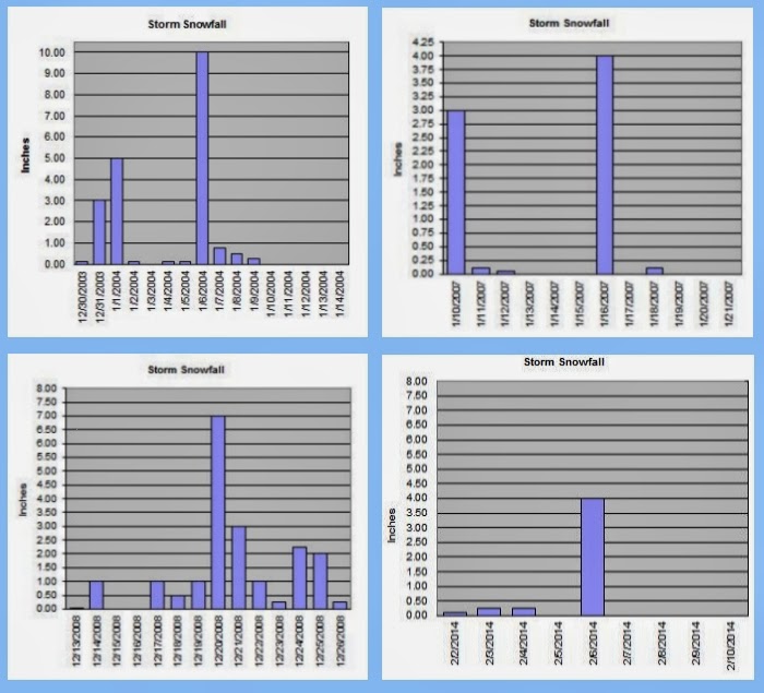
So the five year pattern of big snow events seems to be holding intact. January 2004, December 2008 (4 years 11 months later) and now February 2014 (5 years 2 months later). So all you snow haters can relax until the 2018-2019 winter season ;)
March is often a wild and unpredictable month that can see the first 80 degree mark of the season and also snow showers. So get ready for spring, it's closer than you think and by all means; soak it up my friends, soak it up.
Thursday, February 27, 2014
It's Snowtime... maybe.
How's that for a "grab ya" headline? This weekend the NWS has a winter weather special statement up for low elevation snow. This is not anything like the big event earlier this month. In fact this is likely to be a non-event. However, there is some cold arctic air in the nation's interior that the NWS says will "retrograde" back towards the West Coast and that coupled with moisture headed in could mean flurries of light snow showers here in the city. Confidence for metro area snow under 500 feet is still low however so worry not.

Soak it up my friends, soak it up.
Sunday, February 23, 2014
All quiet on the Southwestern Front
After a cold snowy start to February, the snowiest February since I started keeping records at this location 13 winters ago, Mild and typical late February weather has now prevailed. The NWS has a pretty quiet forecast for this upcoming week.

March is coming and it is a fickle month. Although it rarely get really "cold" in March it is a month that can still deliver snowfall and it also can deliver warm temps in the 70s. Who knows what's in store but one thing remains certain; we will find out soon.
Soak it up my friends, soak it up.
March is coming and it is a fickle month. Although it rarely get really "cold" in March it is a month that can still deliver snowfall and it also can deliver warm temps in the 70s. Who knows what's in store but one thing remains certain; we will find out soon.
Soak it up my friends, soak it up.
Monday, February 17, 2014
A Real 'Howler' Last Night
I am operating today after a night of nominal sleep. A big blustery storm rolled into the 'Couv' overnight bringing with it howling winds in the 50 plus MPH range and a good soaking rain. All night long the wind ripped through the trees and beat against the side of my house. The rain came down so hard at times it just pounded the windows.
The ground became so saturated that all the earthworms had to surface. I walked out of my front door this morning to find a dozen of those worms taking refuge on my porch.
The good news is, that temps are very mild in the fifties already. As I write this, the sun is playing peek-a-boo with us. We should have a wet and windy week that may be capped off with glorious sunshine in time for the weekend.

As always, soak it up my friends, soak it up.
The ground became so saturated that all the earthworms had to surface. I walked out of my front door this morning to find a dozen of those worms taking refuge on my porch.
The good news is, that temps are very mild in the fifties already. As I write this, the sun is playing peek-a-boo with us. We should have a wet and windy week that may be capped off with glorious sunshine in time for the weekend.
As always, soak it up my friends, soak it up.
Thursday, February 13, 2014
A Tickle of Spring
 A tickle indeed; for spring is certainly fickle. But let us not forget that winter remains till the last of March has been crossed of the calender. Last week's blast of winter has nearly faded into the recesses of our memories. Sure the giant piles of plowed snow in the parking lots is a reminder that winter is still around. But quickly it is melting with these 50s on the thermometer and showers of rain.
The last little pile of snow that remains on my property has been reduced to just a few snowballs worth. Even with warm temps and rain a foot of snow will will leave little reminders of its week of dominance for quite some time.
Today was a nice day with light overcast and moments of sunshine. But tonight a big storm is headed in bring rain and wind here in the valleys and trainloads of fresh powder to the mountains.
Soak it up my friends; soak it up.
Sunday, February 9, 2014
Snowmageddan is over
The mercury pushed its way up past freezing today and the precipitation has stopped. This five year snow event is for the most part, over. The kiddies get one more day off from school to give the neighborhood streets a chance to clear up a bit. later this week it will be back to a normal mid winter cycle of chilly rain and occasional sunshine 'teasery'.
I am not saying that Old Man Winter is completely done. We may see a few flakes fly before the summer birds return, but I doubt we get more than a dusting or two.
 This is the total snowfall from this event thus far. It is possible that we could see a little more snow or freezing rain tonight but I am doubtful that it will amount to anything much.
This will go down as my snowiest February since I started record keeping here in 2001. More than eleven inches of snow has fallen this month and it is only the 9th. Most of this came from the 6th through the 8th.
Temperatures during this event were well below average. The 6th was the chilliest afternoon with a high of just 22.2 and over 5 inches of very light and fluffy snow. The temps stayed in the teens and twenties until today when things began to warm up into the low thirties. After these larger snow events people often start comparing to other snow events over the years. The biggest snow event in the last 40 years was 1980 when Vancouver recorded 42 inches of snow in the month of January! Later that year the mighty Mount St. Helens had her historic eruption.

Here are the seasonal snowfall totals at my station for each of the last 13 winters and an annual average. This year is already a touch above average but no where near the monster seasons we had in '03-'04 and '08-'09. We got a legit shot at beating the 14.05 inches in '11-'12
Get out and enjoy this great winter weather. We only get these super snowy events every five years. Don't fret it, soak it up, my friends, soak it up.
I am not saying that Old Man Winter is completely done. We may see a few flakes fly before the summer birds return, but I doubt we get more than a dusting or two.
This will go down as my snowiest February since I started record keeping here in 2001. More than eleven inches of snow has fallen this month and it is only the 9th. Most of this came from the 6th through the 8th.
Temperatures during this event were well below average. The 6th was the chilliest afternoon with a high of just 22.2 and over 5 inches of very light and fluffy snow. The temps stayed in the teens and twenties until today when things began to warm up into the low thirties. After these larger snow events people often start comparing to other snow events over the years. The biggest snow event in the last 40 years was 1980 when Vancouver recorded 42 inches of snow in the month of January! Later that year the mighty Mount St. Helens had her historic eruption.
Here are the seasonal snowfall totals at my station for each of the last 13 winters and an annual average. This year is already a touch above average but no where near the monster seasons we had in '03-'04 and '08-'09. We got a legit shot at beating the 14.05 inches in '11-'12
Get out and enjoy this great winter weather. We only get these super snowy events every five years. Don't fret it, soak it up, my friends, soak it up.
Friday, February 7, 2014
We were due...the snow debt is paid.
 |
| Feb 6th, 2014 approx 3 PM |
Yesterday I received about 5-6 inches of snow. There was only about 4.5 measurable because the first few hours of snow came in sideways and drifted several blocks away. I will officially record 5 inches since I can't be certain how much blew off and ended up in that 18 inch drift down the street. I probably had 6 inches.
 As I write this, there is a break in the cloud cover and that February sun is trying to exert some dominance over this snow. The temp is in the mid twenties now but I am sorry 'El Sol'; you don't have the amps to bust threw this cold air layer today. When the next low pressure system arrives it will pull cold air in through the gorge to fortify this as an all snow event. The National Weather Service has posted another Winter Storm Warning and they expect another 2-6 inches in the city and of course varying amounts in all the assorted neighborhoods. I would expect to at least match yesterday's totals here. If that pans out, I will have close to a foot on the ground and that really is a five year event.
My personal record snows are not likely to be broken but this could end up second or third. I have been keeping snow records at this location since 2001.
Yesterday the temps remained in the very low twenties and teens and the snow was mountain dry. Very ineffective for snowmen or snow balls. With my temperature expected to get up towards 30 degrees this next round will likely be a little more moist.
Our friends in the upper Mid-West will post tweets about us with RAOFLMAO at our shut-down the town attitude over less than a foot of snow. But what they fail to understand is that the 'Couv' is home to some 300,000 people and has fewer snow plows than a Mid-Western town of 30,000. Spokane, Washington is the urban snow king in the State of Washington, averaging 49 inches of fluffy white precipitation each year which is about the same as Minneapolis, MN. They have more than 60 snowplows and Spokane is roughly the same population as the 'Couv'. When Spokane gets a 6 inch snow event, they can easily plow the streets in a relatively prompt fashion. Vancouver has... wait for it... 8 plows. So I don't know about our larger neighbor to the south, but I understand Portland has a similar problem. So yes my friends SIX inches will shut down this town! It takes a much larger event to cause widespread problems in the upper Mid-West but when those areas reach the point that their snow removal is ineffective; lo and behold they look just as silly as we do.
We also don't use rock salt because of Columbia River environmental concerns, so the snow piles up and hard packs on the roads. The plows can only hit the main arterial roads. Neighborhood streets will thaw naturally before a truck ever finds its way down any suburban lane.
So stop laughing at us; these "big" snow events are not common enough to justify the expense of a major snow removal staff. However, note to Vancouver City Council, having a private force of snow removal people on call could be a solid idea. There are a lot of farmers with tractors that plow private shopping centers so why can't you hire those guys to hit the streets of the 'Couv' when these snowzilla events take shape? Yeah good idea, I know ;)
Enjoy our snowy extravaganza and by all means; Soak it up my friends, soak it up.
Wednesday, February 5, 2014
Cold and snowy...maybe.
 |
| The Dangerously Majestic, Mount St. Helens 2-5-2014 |
The NWS updated it's forecast today taking out the bitter cold temps and replacing them with a slightly warmer and snowier scenario beginning tomorrow.

How much snow? Well, it could be a little or it could be kind of allot. The second storm coming in on Saturday will have copious amounts of moisture but it will also have warmer air associated with it. The warm air will erode the cold air at the surface which provides for a transition from all snow to sleet, then ice and finally rain. How quickly that transition happens will have a huge impact on how much wintry precipitation we get.
Hold on to your hats... this is gonna be a fun ride. Get out and enjoy this cold sunshine before the white fluffy stuff comes. Soak it up my friends, soak it up.
Saturday, February 1, 2014
A Big Bowl of Burr, is Headed our Way
January is done and temperatures were par for the course. It all averaged out to pretty close to normal. The average daily low was 33.88 just a tick above normal and the average daily high was 45.89 a little more than a degree on the warm side. The coldest temp was a chilly 22.8 on the 5th and the warmest was a balmy 55.2 on the 24th. We managed to get above freezing every day with the chilliest afternoon a foggy 37 on the 4th and the warmest overnight low came on the 10th with a toasty 46.2.
 Once again rainfall was the topic of trouble. It was a well below average 3.78 inches in the bucket. We had 15 days with subfreezing lows and a whooping 8 days with the mercury buzzing around in the 50s. Only 10 days were rainy and 11 days were sunny. More sun than rain in January? Yep. You don't see that very often.
Nary a flake of snow was seen in the month on January down here in the city. Overall it was a ho hum winter month that never really got too cold and frankly it was nice more often than not. I have no complaints about that!
Things are going to change back to more wintry condition this week however. More of that wonderful arctic air is set to drop in over us. There will be some cold and dry days and possibly some cold and white, fluffy days. Tough call on snow this late. The mighty fireball manages to get up a little higher in the sky as we move closer to spring. That means it can do a better job of warming the air. So I doubt it will be single digit cold like it was in December but teens here at my station are not out of the question. It looks like a big bowl of burr, is headed our way.
Since I have been keeping records at this location I have not had much snow in February. In fact, I average quite a bit more in March. But the law of averages says February is due, so I say bring it on.
Once again rainfall was the topic of trouble. It was a well below average 3.78 inches in the bucket. We had 15 days with subfreezing lows and a whooping 8 days with the mercury buzzing around in the 50s. Only 10 days were rainy and 11 days were sunny. More sun than rain in January? Yep. You don't see that very often.Nary a flake of snow was seen in the month on January down here in the city. Overall it was a ho hum winter month that never really got too cold and frankly it was nice more often than not. I have no complaints about that!
Things are going to change back to more wintry condition this week however. More of that wonderful arctic air is set to drop in over us. There will be some cold and dry days and possibly some cold and white, fluffy days. Tough call on snow this late. The mighty fireball manages to get up a little higher in the sky as we move closer to spring. That means it can do a better job of warming the air. So I doubt it will be single digit cold like it was in December but teens here at my station are not out of the question. It looks like a big bowl of burr, is headed our way.
Since I have been keeping records at this location I have not had much snow in February. In fact, I average quite a bit more in March. But the law of averages says February is due, so I say bring it on.
Sunday, January 26, 2014
The Glorious Sunshine Continues
The mercury bottomed out right at sunrise around 7:45-8:00 AM at a chilly but not too cold 25.8 degrees. We are soaring on our way up the upper 40's this afternoon. There is nothing but gorgeous blue space overhead and a raging ball of fire blazing its way across the winter sky. I have the good fortune to be showing property today under these fabulous conditions.
Later on towards the first part of February, the long term computer models are suggesting a more wintry pattern may develop. Some snowflakes and other assorted freezing precipitation may find its way back to the 'Couv'.
So get out and soak it up my friends, soak it up.
Later on towards the first part of February, the long term computer models are suggesting a more wintry pattern may develop. Some snowflakes and other assorted freezing precipitation may find its way back to the 'Couv'.
So get out and soak it up my friends, soak it up.
Thursday, January 23, 2014
Are you kidding me with this sunshine?
 |
| 31 degrees at 9:45 AM under sunshine as I took my dog to the vet this morning |
January is a month that typically is limited to a couple of days with El Sol running the show. This month has had a whole winter's worth of clear days. That pesky fog has socked us in at times over the last several weeks but days like today have not been by any means a rarity. Generally a clear sky yields lows in the 20s and we have had those, but when the thick fog is absent that late January sun can warm us into the 40s pretty easily.
 |
| The view out the window of my home office as I write this |
We have less than three inches of water in the bucket and the month is almost done. I think we need a big fat wet storm to come in. One of those southern "pineapple express" deals would hit the spot. But until that happens just get outside. Soak it up my friends, soak it up!
Saturday, January 18, 2014
Oh So Gorgeous Today!
It was a gorgeous afternoon today with a high around 44 at my weather station under big bold sunshine and a clear blue sky. It was just fantastic after all these rainy and foggy days since the New Year. The next week appears to be either more of the same or more fog but darn near dead average for temps with lows right at freezing and highs in the low 40s. Ho Hum winter :)
Get out and soak it up my friends, soak it up.

Get out and soak it up my friends, soak it up.
Subscribe to:
Posts (Atom)