Yes I completely failed to collect my data and post last month. That's OK I have it all collected now so I'll post two months of data this go round. I must have had residual heat stroke from the all time record breaking heat wave in June :)
So July was more or less an average month. I mean seriously, reads like a "normal" July with little in the way of temperature fluctuations other than being warmer overall than average. Sure we had few 90 plus days at the end of the month. Over all the chart is super flat on temps for the month. July had no measurable precipitation at all. This is not by any means rare, but it is unusual to have the entire month of July bone dry. July had a max high of 95.6º and a max overnight low of 70.2º. We don't get overnight lows in the 70s very often round these parts. The coolest daytime high was 74.2 which is just a few degrees under average. The coolest temp was an overnight low of 56.3º which is also just a tick under average. Overall July was warmer than average by about 4º both over night and daytime highs. The month yielded 23 sunny days, no rainy days, 3 days above 90º and 14 days with overnight lows above 60º.
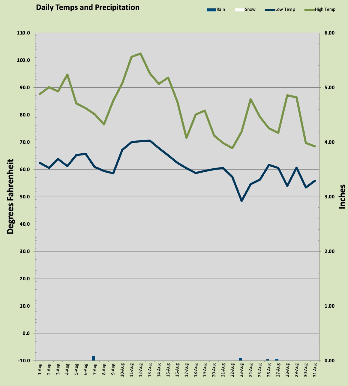
August was more temperamental than July this year. Despite having two days above 100º the overall month was cooler than July by a couple of degrees. August saw little rainfall with just 0.18 inch at my station with three days having measurable precipitation. The warmest day was 102.4º one of two triple digit marks for the month the other a day earlier. Both century toppers were daily record highs. The warmest overnight low was 70.5º one of two overnight lows that stayed above 70º. The coolest temperature was a nippy 48.5º late in the month and the coolest afternoon high was 67.8º one of four days that failed to reach 70º. There were 12 sunny days, 3 rainy days (sort of drizzly really) 8 days above 90º and 20 days with lows in the 60s or higher.
September is looking pretty typical thus far. This is the month that usually begin our great Autumn slide from warm to cool. The normal daytime highs begin in the upper 70s and drop precipitously to bare 70º by month's end. September however is capable of delivering warm and even hot weather but heat spells this late in the season tend to be short lived and less aggressive than those in July and August.
Word on the street is a La Nina condition is building in the Pacific Ocean and that tends to lead us to cool and wet conditions with above average chances for heavy snowfall and low elevation snow. This could be an interesting winter season. 2009 I had an all time record high in July followed by an all time record low in December (record for my station). So who knows, right? We did have an all time record high this summer.


