Tuesday, December 1, 2015

Wow a Chilly Month, Finally

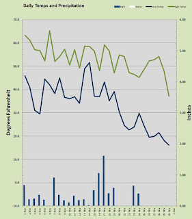
November is done and for the first time in, I don't know how long, I have a calendar month that ended up chillier than average overall. The average daytime high was actually about 3 degrees above my 15 year "normal" but the overnight lows, largely fueled by the very chilly end of month was well below "normal" to the tune of -4 degrees. Overall my mean temp was about 1 degree below normal.

The very last day of month produced one of the chilliest November temperatures I have seen in nearly fifteen years at this location. The mercury bottomed out at 16.1 degrees to cap the end of a long streak of subfreezing mornings. That cold low on the 30th led to the chilliest afternoon high of the month at 37.1. The warmest day of the month was early on when we topped 65 on the 6th of the month. That may be the last 60 plus day we see till the end of February. On the 14th of the month we enjoyed a balmy 51.6 degree overnight low which was the warmest of the month and the only low mark above 50. Overall there were thirteen mornings below freezing and four that dropped below 20 degrees.

On the precipitation front we had one snow threat that delivered zero at my location but some flurries and light sleet were reported elsewhere around town. That of course was the 30th of the month. Rainfall was typical for November with a wet and soggy 9.17 inches which is a little more than an inch above my established normal. This was not the drippy variety as we had 12 days with more than a quarter inch and 2 days with more than an inch of H2O coming down. For the month we had 19 days with precipitation and just 8 under sunny or partly sunny skies. I hope this damp November is a precursor to the rest of the season because I have had two dry winters in a row. Let's not make it a third please.

The outlook for early December is mild and wet. Local weather prognosticators are calling for showery conditions beginning tonight and lasting into next week. Let's hope for soggy and maybe some fluffy white in time for Christmas. I know, a white Christmas in the 'Couv' is a rare deal. I have had but one since moving to this location almost 15 years ago.

Whatever the weather, get out and soak it up my friends, soak it up.

Sunday, November 1, 2015

Warm-Tober

That was a pretty warm October. No record breaking events but definitely toasty and that has just been the case all year long. The average daily high for October, 2015 was a smoking 6.5 degrees above my 15 year "normal" and the overnight lows averaged three and a half degrees over as well. This was not due to an anomalous heat wave skewing the average, in fact, just one day recorded a temperature above 80 degrees.  No it was just really mild and that typical Autumn plunge just never materialized.

If October is a precursor to our winter we can expect a classic El Nino with warmer than average temperatures and drier than average conditions. But harbinger-smarbinger, last year we had the earliest sticking snow in my 15 years of record keeping when a one inch dusting stuck and stayed for a few days beginning on the 13th of November. Some precursor that was, it ended up being the only snowfall for the whole season!

October finished up with an average daily high of 65.93 degrees and an average overnight low of 48.82 degrees. The warmest day came on the 5th when the mercury hit 83.8 and the coolest temperature was the 23rd when it dipped to 37.9 which was the only sub 40 mark all month. The coolest afternoon was the 28th with a mild 54.5 and the warmest overnight low came on the 27th with a near summer-like 57.5. In total 18 days stayed above 50 degrees overnight and 25 days had high temperatures at 60 or more degrees.

Rainfall was deceptive. Up until and through the 30th of the month a mere inch and three quarters had fallen into the gauge. Nearly two inches more fell on the soggiest Halloween I can remember saving the month from a desert dry finish and bringing the total to near normal at 3.77 inches which is about 85% of normal for my location. Just 7 days with measurable precipitation and only 5 over .25 inch. The wettest was of course Halloween with that monsoonish 1.96 inches.

I have yet to yield a frost and haven't gotten any where near a freeze yet this season. It is quite likely that the first frost will in fact come in November as I have certainly never gone to December without achieving the first frost. In fact my records show that subfreezing weather has always occurred by the end of November to start the winter season.

So get ready for an interesting and potentially wild November, because September and October were truly mild to the point of dull, and I don't think it's possible for three dull weather months in a row, here in America's Vancouver.


Monday, October 19, 2015

Saturday, October 17, 2015

Flash, Boom, Swoosh!

Bob Segar once sang of this phenomenon although in an entirely different context.

I woke last night to the sound of thunder
How far off I sat and wondered
Started humming a song from 1962
Ain't it funny how the night moves
When you just don't seem to have as much to lose
Strange how the night moves
With autumn closing in

Last night, or more aptly early this morning, I awoke to the sound of thunder. How far off I need not wonder, for there was little time between the crackle and the boom. Then came the swoosh of heavy rain. Autumn truly is closing in.

Thursday, October 1, 2015

September is Toast : Hello Autumn

So the last of the summer has rode off into the sunset. Sure October can flash an 80 degree day... occasionally, but probably not. No my friends Autumn is upon us and although this last summer was very feisty I doubt she'll muster much more in the way of heat. Having said that there has been a precedent for a 90 degree day in October but you have go back to the days when a Mullet was fashionable to find it. Just say no to the Mullet and no to 90s in October.

September turned out to be a pretty standard fare with one day popping up over the 90 degree mark and a few days that failed to reach 60 degrees. Our very first 30s appeared for the season towards the end of the month and that is all pretty routine. Over all the month was a tad on the warm side trending with the rest of the summer this year. As has been the case all year long rain was light with a little more than have the normal amount hitting the bucket.

The warmest day was the 11th with a mark of 91.4 degrees and as mentioned the only 90 plus day. That was however the 18th day of 2015 that busted through the 90 barrier, which is about double the usual number for a calendar year at my station. The warmest temperature overnight was a mild 57.7 degrees on the 12th of course the evening following the 91.4 high so that fits like the proper puzzle piece. The coldest temperature came on the morning of the 28th when the mercury dropped into the 30s for the second time in September to a chilly 39.3 degrees. The coolest afternoon high came on the 6th under showery skies with 57.9 degrees. This was one of two days this past month that could gather enough strength to hit 60 degrees.

Overall the average daily high was 74.1 degrees about 2 over and the average low came in at 49.82 about 1.5 over. really this was a garden variety September.

On the water side, rainfall was light. It is not unusual for July, August and September to be dry, in fact they typically are. April, May and June however were very dry this year so we could have used a little extra this past month. No such luck would be had as the bucket showed 1.39 inches when a typical mark would be 2.47. The wettest day came on the 17th when a soggy 0.69 inches fell. This was one of 7 days with measurable rain. Only two managed to bring us more than a 1/4 inch. I had 19 days with mostly sunny skies and no frost.  

Tuesday, September 1, 2015

August is done, is that Autumn I see peeking over the fence?

Many people enjoy a good long summer. And a good long one we have had. Generally this part of the country sees 75 days of summer starting around the first of July and ending in early September. But this year our warm and dry weather began all the way back in May! It was well above average in terms of temperatures and well below in terms of rain. Nirvana for some and for others it's "Hey Autumn come on over, Summer has worn out its welcome".

August was a bit warmer than average but not as warm as July. Temps ran just a couple of degrees on the upside both overnight and by day. Average daily high for the month was 82.22 and the average low came in at 57.73 degrees, 2.2 and 1.3 degrees above normal, respectively.

The heat monster maxed out at 96.4 degrees on the first day of the month, following a short triple digit episode at the end of July. This was one of three days last month that breached the 90 degree barrier. That is about normal for August. The coldest temperature recorded was a nippy for summer, 49.2 on the 22nd one of two evenings to drop into the 40s. The coolest afternoon high came on the 30th under blustery and wet conditions and was the only day that failed to reach 70 degrees with measly 67.2 measured. The balmiest night was a comfortable 65.1 on the 12th.

The drier than average trend has continued with August posting 0.81 inches compared to my typical 1.27 inches. July and August are often very dry so it is of no consequence like it was in May and June to have these conditions. The wettest day came on the 29th when 0.31 inches fell.

Overall the month of august was actually pretty typical if not just a tad on the warm side. One can only hope that the fall will bring with it some much needed rain and may the winter bring a healthy snow pack to our abnormally barren peaks.

Get out and soak up the last of summer my friends, soak it up!    

Saturday, August 29, 2015

Blustery and Wet Late August

Here we are at the end of August and nearing the end of what has been a toasty warm summer thus far. But as August comes to a close we find ourselves in a bit of a fallish pattern, albeit warmer than October, I awoke to the sound of heavy rain and brisk winds. The rain is most welcome as our California dry look needs a little greening up :)

The temps should remain comfortably in the seventies as we enter the month of September with some wind and rain to remind us that this IS western Washington!

Go ahead, soak it up my friends, soak it up.

Wednesday, August 19, 2015

The Heat is On... Again

Well over 90 degrees today and probably again tomorrow. We have had at least 20 days over 90 and even some triple digits so this summer will go down as a warm one. Fear not,  ye who prefer our cooler days, more seasonable temps are coming soon. oh go ahead and soak it up already, soak it up my friends.

Saturday, August 1, 2015

Hello August

July is in the books and it went down as a toasty month. 11 days in excess of 90 degrees! That's two more 90s than I normally record all year. The month close out on a hot note with the highest temp of the year thus far on Thursday the 30th at 101.7. That triple digit heat was the first century mark I have hit since August of 2012.

The month of July 2015 was much like the month of June 2015, HOT. The average daily high was a whooping 5 degrees above my established norms at 84.76 and the overnight lows averaged about plus two at 58.64 degrees.

Here is the breakdown of the July numbers from the weather station. The hottest day was the aforementioned 30th with that four place holder, 101.7. The warmest overnight low was a still comfortable, 64.2 on the 5th. The lowest temp for the searing month of July, 2015 was a cozy-cool 53 flat on the 28th. This furnace fed weather was not without some mild days and the coldest afternoon high was delivered on the 25th with a nice 65.1 degrees and some cool refreshing showers.

Overall the month had one day in triple figures and eleven days above 90 degrees. There were 3 days with measurable rainfall.

Now that I am on the subject of rain, this has been a pitiful year for precipitation. This past July was close to average for me with 0.75 inches falling against my "normal" of about 1 inch. But this July was wetter than either May or June! You don't see that very often 'round these parts. The wettest day was the 26th when 0.41 inches found their way into the rain gauge.

So August began like July did with today's high at my house another blistering mid-ninety degree day. We shall see if August plays with the thermostat or she keeps the heat on. Whatever the weather may be, soak it up my friends, soak it up!

Saturday, July 25, 2015

Rain? In July? Sometimes.

We shouldn't complain after that toasty warm and desert dry episode we called June, 2015. But I awoke this morning to the sound of raindrops for the second time this month. July on average is our driest month with a typical rain gauge reading of about 0.50 to .075 inches for the whole month.

I think we will blow that up this month. Generally I always tell people you can count on July and August being pretty dry and that has held up even this year.

For now I am sitting at my computer, looking out the window at a stand of towering fir trees in the neighborhood as the soothing drips of a cool summer shower soothe the soul. Go ahead, take a walk and soak it up my friends, soak it up.

Wednesday, July 1, 2015

June was... Well... July-ish

The month of June is in the books and there is no other way to say it... It was VERY WARM. Although I never saw the realization of triple-digit heat like the NWS was suggesting, It was warm in general across the whole of the month.

Just so we are clear, prior to entering the data for June 2015, my 13 year average high for the month was 70.68 degrees. After entering this year's data that number jumped to a 14 year average of 71.52. That is nearly a full degree just from one month's data. The average daily high for June, 2015 was an warm 80.48 degrees and that is TEN degrees warmer than the previous 13 year average for the month.

June is a spring-summer transitional month weather wise. Generally we have a mix of cooler spring weather and some warm summer weather. This June was bone dry and very warm. How about 26 sunny days! That is about three June's worth of sunshine my friends.

As wonderfully warm June was, it was woefully dry in a year that has already been arid over all. My location is 10 inches drier than average through the first 6 months with a paltry 15.91 inches of precipitation. The NWS is suggesting July may end up without any precipitation. We could sure use some wet stuff.

Here is how everything played out. 26 sunny days and just 3 with rainfall. the month of June had 17 days with 80 or more degrees on the mercury. The aforementioned average high of 80.48 was nearly ten degrees over the normal with an average low that was just over 55 degrees; that's about 3 over my established norm. The hottest day came on the 26th with a mark of 94.6 degrees, The balmiest overnight low followed the hottest high with a mark of 68.1 on the morning of the 27th. The coldest daytime high came early in the month during some squalls. The 2nd was the only day in June that failed to reach the 60s with an "almost there", 59.3 degrees. The coolest overnight low was a chilly 45.6 on the 13th.

We had 3 days at 90 plus and 5 with overnight lows in the 60s. We also had some contrast with 4 nights in the chilly 40s.

Here is the real shocker. My location only recorded a measly 0.53 inches of rain. That is July dry and well under my normal of 2.47 inches. Get ready my friends for a warm summer filled with sunshine and smiley faces. Then prepare for the typical angry winter that follows such frolicky summers. Ah, go ahead in soak it up my friends; soak it up!

Wednesday, June 24, 2015

Get Ready to Feel the Heat!

The National Weather service is sticking to their earlier projection for triple digit heat. As we approach the end of the week a new element has arisen. We may be treated or more aptly "subjected" to a southern style event with super hot conditions and humidity added in just for fun. NWS thinks that thunderstorms could be in the mix. It has been several years since I remember hot and muggy conditions. Get ready for a little Cajun weather my friends and always find a way to soak it up :)

Tuesday, June 2, 2015

Adios May and Hello June

OK the whole month of May I was radio silent. I can sum up the month in a single word, "mild". May was also a bone dry month with rainfall landing in the bucket like it was July. Temps were soft and creamy and we had a fair bit of cloud cover despite the modest amount of precipitation.

Overall May was a bit on the balmy side with the average lows and high coming in around two degrees on the plus side. It was warm on the ends and cool in the middle for the most part but nothing extreme at all.

The coldest morning was a brisk 39.3 on the 7th and the coolest daytime temp came in at 54.6 on the 12th.

We enjoyed a month that delivered a dozen days above the 70 degree mark and of those a third were above 80 degrees. But the warmest day was a mild and delicious 82.7 on the 28th. The warmest overnight low came on the 21st with a comfortable 56.1 degrees.

In the rain gauge there was just nothing happening. Despite a few aggressive thunderstorm cloudbursts, nothing fell long enough to impress the spreadsheet. Seriously, 0.58 inches in MAY! What the hell is that all about? That is about one sixth of my typical precipitation for the month often described as "merry". The wettest day yielded a paltry shower of 0.18 inches.

Like I said before, one word; "mild".

June began with the clash and bang of thunder and lightning followed by some heavy rain. This week is looking like a warm one after the hump so get ready to feel some summer. Get out and soak it up my friends; soak it up.

Friday, May 1, 2015

April Showers Were Light

The showery month of April is in the books and I had about half my typical April rainfall. I was delighted to post the first 80 degree mark of the season however so that was nice. April was all over the place with several warm days and a few chilly nights but no extremes really at all.

We managed to get all the way through the month of April with out ever dipping below the freezing mark. We got close a few times but I managed to stay above the whole way through. all but one day managed to get above 50 degrees as well.

The warmest day of the month was the 27th with a toasty 81.6 degrees as I said before, the first 80 plus mark of the season. The coldest temperature was recorded the morning of the 15th with a 33.2 mark on tax day! The warmest overnight low came on the same day as the warmest high with a low of 49.4 on the 27th. The coldest afternoon high arrived on the 14th with an almost 50 mark of 49.8 degrees. We enjoyed 8 sunny days, 12 with rain.

Speaking of rain. I only managed to record 2.15 inches for the whole of April and my typical mark is 4.24 inches. Only half as much as "normal". The wettest day was the 14th with 0.41 inches. We had several days with angry thunderstorms that dumped torrents of rain in isolated areas. Some areas nearby likely recorded an inch or so more than I did if they got hit with those cloudbursts.

The merry month of May is under way and I think we will see more and more of that big yellow orb so be sure to get outside and soak it up my friends, soak it up.

Wednesday, April 22, 2015

Monday was warmest day of year!

All the weather prognosticators were calling for an 80 degree mark on Monday and I sure got close but no cigar. Some locations locally achieved the milestone but I registered a 78.6 degree mark. That was good enough to be the warmest so far this year.

After all that warm weather over the winter, I figured 80 would have come in March. It looks like it may have to wait until May.

It's all good though mid to upper 70s is fine by me :)

Get out and soak it up my friends, soak it up.

Thursday, April 16, 2015

Some Serious Sequential Sunshine

That National Weather Service has a forecast that most people around these parts at this point in the year will find most pleasing!


All that pretty white snow clinging to the foothills doesn't stand a chance against this week of glorious, sunnylicious ecstasy! Oh sunshine and seventies how we miss you so. Who knows maybe that first 80 degree mark of the season will slip into the mix. Probably not, but you never know.

Well you really don't have an excuse now, so get out and soak it up my friends, soak it up.

Wednesday, April 1, 2015

It's Snowing Outside!

April Fools!

It is definitely not snowing outside today nor in fact has it snowed at all this year! Frozen precipitation this time of year tends to arrive in form of hail from thunderstorms. We had some of that over the last few days for sure and more will likely arrive locally today.

March is in the books and it was a bit of a roller coaster ride which is par for the course in what is generally the most tumultuous month of the year.

The mighty month of March delivered to us out first 70 degree temperature of the year and the first since October 17th. That glorious 71.9 was the first and only 70 thus far and it came on the 27th. But March was not shy about playing in the sixties as that happened 17 times! This was overall a balmy little March with an average high of 61.35 degrees nearly 7 degrees above my 13 year average! As is true with most late winter early spring transitions, there was some chilly temps as well. I observed a slightly warmer than normal average overnight low of 40.58 and 1.5 degrees higher than typical. The chilliest night came early in the month, no surprise there. A 27.3 degree low on the 4th was one of only 4 subfreezing days and only 2 in the 20s. The warmest minimum temperature came on the 14th when the coldest it got was toasty 51.4 and the chilliest afternoon was also a balmy 53.7. This is the first March I have recorded in 13 years at this location where all 31 days broke the fifty degree mark.

Precipitation was a little on the light side with 4.86 inches in the bucket against my average for March of 5.52. There was no frozen precipitation aside from a few bouts of hail from highly localized thunderstorms. In fact, nearly half of the precipitation fell on just two days, the 14th and 15th where 1.35 inches came on 14th followed by .90 inches the next day. March was kind enough to deliver 14 sunny days and just 11 with rain.

Looking forward to the rest of the week should be mostly showery with isolated thunderstorms. April is here and the big question is: will she deliver us our first 80 degree mark? we shall see; in the mean time, get out and soak it up my friends, soak it up.

Wednesday, March 25, 2015

Heavy Rain, Thunder and Snow

Well we have had very little low elevation snow this past winter season and as spring open there was nary a flake of snow on the foothills. Only the majestic and mighty Cascade volcanoes were wearing a mantle of white the day Miss Spring took the reigns of control. This past weekend brought some thunderstorms and quite a bit of heavy hail in some of our valley locations. The foothills got a dusting of snow down to mid-slope at around 2500 to 3000 feet.

It seems we have transitioned from dry to wet over the last week or so. Local hydrologists have been worried that a weak snow pack in the Cascades could lead to an early and possibly dangerous fire season this summer. Let's just hope the springtime delivers some tasy snow events in the foothills and the high cascades to help keep us lush and green through the summer. meanwhile get out and soak it up my friends, soak it up :)

Monday, March 16, 2015

A Soggy Soaker Weekend leads to Sunny week, again.

It rained good and hard this past weekend, but the sun is back today and the mercury is settling in the mid sixties today. Looks like spring is back just as it has been all winter long it seems. This week will be a fickle springlike episode with rain and sun followed by more rain and sun. Soak it up my friends, soak it up.

Sunday, March 1, 2015

Another Warm Winter Month in the Books

February continued this winter's trend of warmer conditions as the chart show those FIVE days above 60 degrees quite well and the real shocker is that 24 of the 28 days of this past February saw the mercury push past 50 degrees. Perhaps even more surprising was the fact that I recorded only two sub-freezing temperatures all month.

All that warm sunnylicious goodness came at the expense of rain where I saw a well under average 4.17 inches.

A closer look at the month's statistics reveals the deliciously unseasonable nature of this winter. The warmest day was a very nice and cozy 64.7 degrees on the 17th one of three 60 plus days in a row and five 60 plus days on the month! The chilliest overnight low was a modest 29.3 degrees on the 24th. We had a few overnight lows that tickled the 50 mark the warmest of which was 49.8 on both the 6th and 7th. These were two of the 12 days with warm low temps in the 40s. The nippiest afternoon high came on the first day of the month with a mild 44.6 degree reading which is pretty close to normal for early February at my house. Looking at the temperatures across the whole of the month I was five degrees above normal for overnight lows with a month observed average coming in at 39.67 degrees against my 14 year normal of 34.76. The daytime highs were nearly 6 degrees above my normal of 49.41 as I observed an average 55.49 degrees.

On my website I post a 90 day trend chart and the last 90 days has absolutely zero snowfall. December, January and February without so much as a flurry? WOW! As for precipitation for February I mention that I recorded and under normal 4.17 inches, which is not drought numbers by any measure but low none-the-less. The wettest day was the 7th with 0.80 inches falling, the last of three straight days of steady rain over 0.50 inches. I had six days with more than 0.25 inches and 11 days with measurable rain. It is not very often in Western Washington that you get more sun than rain but I had 12 sunny days :)

March is coming in like the proverbial lamb as I am typing this under brilliant sunshine at as the mercury is nudging its way towards fifty degrees at 11 in the morning. So will the fickle month of March bring us any more snow for this season? Honestly you really never know. All the long term forecasts are suggesting that March will continue the mild streak we have had since January. If that pans out I'll end up with a paltry 1.1 inches of snow on the season which is well under my 14 year average of 9.37 inches. That is really not too unusual, Western Washington routinely has winters with very little snow and rarely has a winter with more than 12 inches. All of you snow-haters can relax, looks like you will have a reprieve until next winter. So go outside and soak it up my friends, soak it up.
 

Saturday, February 14, 2015

The Heat Wave Continues with balmy 50s and even some 60s

February has been more of the same following a warm January we now have a warm February thus far at the halfway mark. It makes me wonder about March.

Yes, I went there. March is a month than can be sunny and warm or it can be cold and cranky. In 2012 I had nearly 8 inches a snow in March. That year was moderately chilly though so I don't expect a repeat affair this year. But I have recorded a few warm January-February combos that were followed by a vigorous wintry March. Typically the snow is light dustings that barely last the day.

I wonder what March 2015 will bring? I say bring it on, I only have 1.1 inches of snow this season thus far.

We shall see , but for now get out and soak up some sunshine on this 2015 Valentines Day, yes soak it up my friends, soak it up.

Monday, February 2, 2015

January and Football are Both Done!

What a super bowl game that was yesterday huh? That marked the end of the football season and this weekend put the first weather month of 2015 in the books as well.

This somewhat warm winter continues with above average temps for January. The average low ran 3 degrees above normal with 35.36 and the daily average high ran nearly 5 above at 48.71. That is a January average daily high of darn near 50 degrees. What is this, Northern California? No it is not, but the weather is sure trying to fake us out. We managed to hit a downright toasty 62.2 degrees on the 24th and that is the warmest January temperature I have recorded in January since I started keeping records in 2001. It is also only the second 60 plus reading in January over that time period. We had a mild 46.2 overnight low on the 28th which was the warmest of the month. The coldest temperature reading came on New Year's Day with a 19.5 degree reading which is legitimately chilly but no where near a record for the date. The coldest daytime high was a mild 39.3 degrees on the 2nd of January also no where near any records. January delivered 9 days with sub freezing temps and an amazing 13 days with highs above 50 degrees!

On the rainfall front we were kind of dry. I measured just 3.62 inches which is about half of a typical January. I did have one drenching deluge on the 17th when 1.9 inches came down. I did observe a few days with mixed precipitation but nary a flake of snow that stuck to the ground. That early dusting in mid November remains the only sticking snow of the season.

January was a warm month but weather-wise it was rather uneventful. Get out and soak it up my friends, soak it up.


Sunday, January 25, 2015

Warm and Sunny...In January!

Yesterday my mercury topped out over 60 degrees! That high mark at 3pm hit 62.2 and was a personal record for that date with my previous record high for a January 24th coming in at 57 degrees. We had several National Weather Service records fall around the area as well. A toasty warm day in January is not unprecedented, but it is unusual. This whole winter save for a few weeks of nippy cold, has been quite mild.

We still have two months of winter to go and you never know, it could turn chilly on us. Don't get too comfy in those shorts and tee-shirts just yet.

While we have go ahead and soak it up my friends, soak it up.

Wednesday, January 14, 2015

The Warm Winter Continues

I can't say if we will get cold again this year or not? Temps have been running consistently 5 plus degrees above normal and I don't see a change. You never know, and Arctic air mass could drop down from the North anytime. While we wait for that to happen, just get outside and soak it up my friends, soak it up. I am in the upper forties with big, bold sunshine beaming down from the heavens.

Friday, January 2, 2015

Happy New Year!


2015 has arrived! OK it is January second and I suppose you figured that out already. I would like to wish all of you a happy and prosperous new year.

December 2014 was a balmy month, I mean way above average on the temperatures. The observed average high for the last month of 2014 was 47.13 degrees nearly 5 above my 13 year average at this location. The observed average low last month was a toasty 37.79 more than five above my 13 year average. Hopefully I'll smile when I get my heating bill for December.

December started off by continuing a very chilly cold snap that ended November. The first two days of the month had lows of 19.7 and 21 respectively and daytime highs of 27.4 and 36.1. Hey it was December, no big deal. But then the next 26 days were essentially a winter heat wave! The month managed to close out properly as the 30th and 31st recorded lows of 20.4 and 18.6 respectively and highs in the mid thirties. Now that is more like winter.

The coldest low occurred on the last day of the month with that aforementioned 18.6 mark. That was no where near any records but legitimately chilly. The warmest temperature came on the 11th with 58.8 degrees. Well shy of my December record of 59.9 but the warmest December 11th I have yet to record at this location. The coldest daytime high temperature came on the very first day of the month with that 27.4 mark and the warmest overnight low occurred on the 21st. Longest night, warmest temp? That's weird; I didn't see that coming.

This last December was unusual in that I recorded 16 days where the low temperature was up in the 40s! I only had 5 days with a sub freezing mark and 5 days with highs below 40 degrees. well the jury doesn't have to deliberate long on this case, December 2014 was a warm month.

The rainfall was a little light for a December but a still adequate amount of 6.24 inches landed in the gauge. I tend to get around 8 inches in December. We had one really wet day where 1.15 inches splashed down on the 20th. The month was a bit cloudy overall with just 6 days of sunshine and 19 days with at least some rain.

December had a few bouts with wind as we did in November. I lost two fences this season!

Year end stats go like this...

Days lo<32 44
Days lo<20 5
Days lo>40 234
Days lo<50 221
Days lo>60 23
days hi>100 0
Days hi>90 13
Days hi>60 188
Days hi<50 80
Days hi<40 17
Days hi<32 5
Days sunny 158
Days rainy 139
Days Snow/Ice 9
Total Snowfall 12.20
Average Low 46.05
Average High 63.10
Max Temp 98.4
Min Temp 18.6
Wettest Day 2.01
Days >.24 Rain 64
Tot Precipitation 47.83

Get and soak it up my friends; soak it up.