Showing posts with label portland. Show all posts

Friday, February 7, 2014

We were due...the snow debt is paid.

Feb 6th, 2014 approx 3 PM
Every five years or so we get a significant snow storm. The kind like we got yesterday and that will continue today. When all is said and done just about everyone in the metro area will have at least 8 inches on the ground and some will have upwards of 2 feet. The last "big one" was Christmas 2008 just a month more than five years ago. Prior to that event was the snow and ice epic event in January of 2004 just a few weeks shy of five years earlier. Pattern? Perhaps.

Yesterday I received about 5-6 inches of snow. There was only about 4.5 measurable because the first few hours of snow came in sideways and drifted several blocks away. I will officially record 5 inches since I can't be certain how much blew off and ended up in that 18 inch drift down the street. I probably had 6 inches.

As I write this, there is a break in the cloud cover and that February sun is trying to exert some dominance over this snow. The temp is in the mid twenties now but I am sorry 'El Sol'; you don't have the amps to bust threw this cold air layer today. When the next low pressure system arrives it will pull cold air in through the gorge to fortify this as an all snow event. The National Weather Service has posted another Winter Storm Warning and they expect another 2-6 inches in the city and of course varying amounts in all the assorted neighborhoods. I would expect to at least match yesterday's totals here. If that pans out, I will have close to a foot on the ground and that really is a five year event.

My personal record snows are not likely to be broken but this could end up second or third. I have been keeping snow records at this location since 2001.
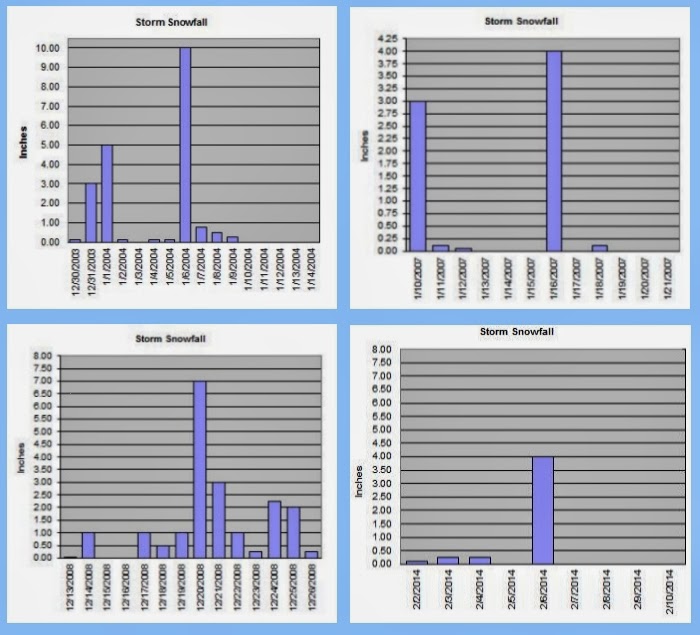
Here are the four occasions in which I had at least 5 inches on the ground since 2001. Yes only four. I have had 41 snow events with at least a trace sticking to the ground in those 13 winters and only a quad with 5 or more inches accumulating. The snowiest single day I recorded was January 6th, 2004 with 10 inches coming down on a day that still stands with the coldest daytime high reading of 20.8 degrees. I was just shy of 20 inches of snow from that event that ran from December 30, 2003 until the last of the freezing rain was done on January 9th, 2004. I had a maximum snow depth of just under 12 inches (a half inch of solid ice over the top). January, 2007 had a snowy and cold spell with 3 inches falling on the 10th some flurries through the week and 4 more inches on the 16th piled on most of the snow that was still hanging around to a depth of 6 inches. The biggest snow event I have had yet however, came on a rare white Christmas here in the 'Couv'. December 2008 was a wild and white month that began on the 13th. Most of the snowfall was light but there was a blast of 7 inches on the 20th. All totaled I had the deepest snow cover of my 13 winters here in NE Vancouver with a whopping 15 inches on the ground on Christmas Day and a storm total of over 19 inches. Since then snowfall has been the more typical for the west side of the Cascades; light amounts with wet and slushy conditions for the most part. Until now.

Yesterday the temps remained in the very low twenties and teens and the snow was mountain dry. Very ineffective for snowmen or snow balls. With my temperature expected to get up towards 30 degrees this next round will likely be a little more moist.

Our friends in the upper Mid-West will post tweets about us with RAOFLMAO at our shut-down the town attitude over less than a foot of snow. But what they fail to understand is that the 'Couv' is home to some 300,000 people and has fewer snow plows than a Mid-Western town of 30,000. Spokane, Washington is the urban snow king in the State of Washington, averaging 49 inches of fluffy white precipitation each year which is about the same as Minneapolis, MN. They have more than 60 snowplows and Spokane is roughly the same population as the 'Couv'. When Spokane gets a 6 inch snow event, they can easily plow the streets in a relatively prompt fashion. Vancouver has... wait for it... 8 plows. So I don't know about our larger neighbor to the south, but I understand Portland has a similar problem. So yes my friends SIX inches will shut down this town! It takes a much larger event to cause widespread problems in the upper Mid-West but when those areas reach the point that their snow removal is ineffective; lo and behold they look just as silly as we do.

We also don't use rock salt because of Columbia River environmental concerns, so the snow piles up and hard packs on the roads. The plows can only hit the main arterial roads. Neighborhood streets will thaw naturally before a truck ever finds its way down any suburban lane.

So stop laughing at us; these "big" snow events are not common enough to justify the expense of a major snow removal staff. However, note to Vancouver City Council, having a private force of snow removal people on call could be a solid idea. There are a lot of farmers with tractors that plow private shopping centers so why can't you hire those guys to hit the streets of the 'Couv' when these snowzilla events take shape? Yeah good idea, I know ;)

Enjoy our snowy extravaganza and by all means; Soak it up my friends, soak it up.


Wednesday, February 5, 2014

Cold and snowy...maybe.

The Dangerously Majestic, Mount St. Helens 2-5-2014
Today has been a gloriously beautiful day... if you are looking out the window of your warm car or office. The fantastic yellow orb is blazing away across a deep blue sky. It could be 70 degrees out there. Until you open the door. Temps are hovering in the mid 20s around the city with a very stiff wind coming out of the gorge. Wind chills this afternoon are teasing the 0 degrees Fahrenheit mark.

The NWS updated it's forecast today taking out the bitter cold temps and replacing them with a slightly warmer and snowier scenario beginning tomorrow.


How much snow? Well, it could be a little or it could be kind of allot. The second storm coming in on Saturday will have copious amounts of moisture but it will also have warmer air associated with it. The warm air will erode the cold air at the surface which provides for a transition from all snow to sleet, then ice and finally rain. How quickly that transition happens will have a huge impact on how much wintry precipitation we get. 

Hold on to your hats... this is gonna be a fun ride. Get out and enjoy this cold sunshine before the white fluffy stuff comes. Soak it up my friends, soak it up.

Friday, December 6, 2013

Itty Bitty Snow Fall with Godzilla Size Hype From Local TV

rodsager.com weather station and webcam
So the very first snowfall of the season is underway and it is quite light. This is not the typical wet slushy snow either. Temps are in the low to mid 20's and what is falling is not only sticking but sticking around. However, not much is falling. Accumulations here at my station are quite literally trace amounts. This is the frozen version of a drizzle.

The local TV news coverage is downright embarrassing. They are quite literally acting like a news crew from Los Angeles reporting on snow in Venice Beach. I am quite certain it has NEVER snowed in Venice Beach.

Here in the Portland metropolitan area however, it does snow, every year in fact. We don't get a lot of snow that is true, but we get it every year. Sometimes we get dumped on like Minnesota and sometimes we get barely a trace. But I witnessed child like coverage of a non-event this morning on the news. Nelson Mandela passed away yesterday guys, that's pertinent news. When there is 3-4 inches covering the ground, then make a big deal. But this; are you kidding me?

So flurries are fluttering in a stiff East breeze and our wind chills will be hovering around zero at times in some areas. The snow is falling sideways, brrr. Bundle up and remember the air is dry and it may not feel as cold as it is. Drive with care, we do not treat the roads for snow and ice so even though there is only a little snow, the road will still be treacherous.

The National Weather Service is indicating that the arctic will be calling in reinforcements for the weekend with even lower temps, possibly into the single digits in outlying areas. It is unlikely that the temperature will rise above freezing today so what falls, stays. We may have a newsworthy event by the end of the day so the children in TV news-land will actually have a reason to get excited.

Winter is here, now get outside and soak it up my friends, soak it up... or stay inside by a warm cozy fire and soak that up, what ever floats your boat.

Thursday, November 21, 2013

Nippiness Has Finally Arrived

Well friends, this autumn has been to say the least, mild.  This morning however was actually quite chilly for mid-November. The mercury bottomed out just before sun-up with a genuinely chilly 20.4 degrees. If it were late December of early January well, so what. But this is pre-Thanksgiving and that is a bona fide cold morning for this early in the season.

The great yellow orb is shining with an amazing radiance however and we should find the afternoon warming well into the 40s. We are going to get a little extended sunshine after two weeks of gloominess so you know the drill...


Yeah, Soak it up my friends, soak it up.

Wednesday, November 6, 2013

Here comes the rain again...

Well the rains of Autumn have finally made an appearance after a very dry October. I was getting a little nervous, after all we have a reputation to uphold here in the soggy Northwest. We had a couple of days that were seasonably chilly to start the month off with snow down to pass levels, but now we seem to be comfortably situated in the low to mid 50s with the customary mid-fall showers. The NWS has a pretty typical early November forecast lined up for this week.


A special weather statement is in effect for tomorrow regarding high winds and heavy rain along with locally heavy snowfall in the passes. Bundle up but go ahead and soak it up too.

Sunday, September 29, 2013

Wild Storm Pummels the 'Couv'

What a ride yesterday! A storm rolled in packing big wind and a brief deluge that would make Noah nervous. The streets are littered with tree branches and other natural debris. This one was packing quite a wallop and the rain was falling horizontal for a good portion of the day. I got over an inch of rain and most of it came in a one hour period of atmospheric rage late in the afternoon. Today it seems we have a little less anger from mother nature but the NWS still has a wind advisory up for the region today. Be cautious and enjoy our misfit behavior in the skies for the next couple of days. Soak it up my friends, soak it up.

Wednesday, September 11, 2013

The Last Ninety for Nine

How is that for a cryptic but quite likely accurate title for this late summer weather blog post? My station hit a toasty 89.4 degrees yesterday tickling ninety degrees but just failing to hit that "it's too darn hot" number. The official station at Pearson had 91 yesterday. Today however will be a different story. Ninety degrees will come quick and early in the afternoon and boil us all day long under a desert like blanket of big, bold, blue sky.

Either there is a Bunson burner under my temperature sensor or the NWS is right on the mark. The forecast today is for mid to upper nineties and if that pans out this will likely be the hottest day of 2013. Take that Autumn! Summer is stabbing at the fall, flailing away with all she has to give. It is that last blast of her furnace before the inevitable chill sets in next month. Today is expected to be the peak of this little heat wave and the last ninety of the year will probably fall on one of these next four days. The next time we'll see a ninety degree day most likely won't arrive until June of 2014. Nine months from now, thus "The Last Ninety for Nine" seems a fitting title :)

Our friends at the National Weather Service have this forecast along with a heat advisory for today.


Maybe this heat is just too much for you. Maybe you are secretly annoyed with Summer's attack on your long awaited season of brisk autumn breezes. Well the coast may offer you the solution. This NWS Cannon Beach forecast supports the conclusion that Coast equals Cool.


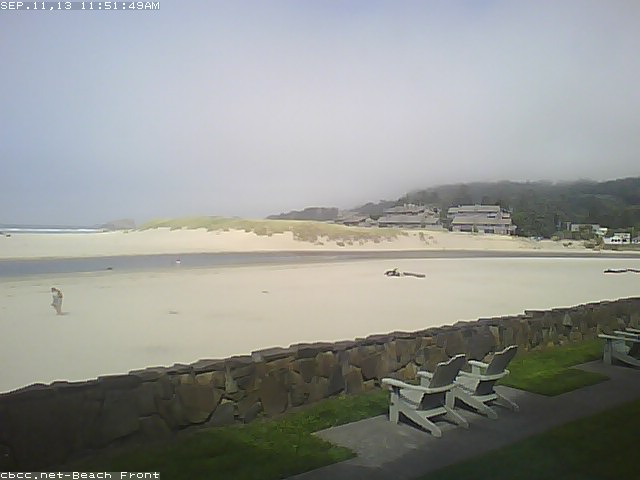
You can always play hooky and drive to the coast. Here is the situation at Cannon Beach, OR. It looks a little foggy right now (Noon) but will probably see a little clearing later on. Temps are almost always cool along the shore. This could be your last opportunity for somewhat warm weather along the Oregon Coast or SW Washington's Coast. As fall approaches the rain becomes relentless along those gorgeous cliffs. Autumn comes quickly.


Maybe the foggy coast is a little overkill on the beat the heat angle. 60's too chilly? OK Timberline Lodge could be the getaway for you! The NWS forecast for the historic Mt. Hood Lodge is 70s and sunshine.


Maybe a short drive up to Hood is just what the doctor ordered for heat expulsion. Keep in mind if you stay overnight it gets downright nippy after ten up at Timberline.


You know what do, get outside and take in the last blast of summer. If you don't fancy mid nineties then you will have to stay inside your cozy air-conditioned office until after 8pm. Of course, you could enjoy the coast or mountains one last time this summer. Either way, soak it up my friends, soak it up.


Sunday, September 1, 2013

August is in the Books

Another gorgeous Northwest month has come and gone. August was stellar, with near perfect weather the whole month long. It started off a touch on the cool side and offered up a little wet stuff towards the end. Even the wet days were quite pleasant however.

The stats were pretty standard for the month of August. I showed not one day above 90 degrees. The official station at Pearson logged two at exactly 90 degrees, however. The warmest day here in Northeast Vancouver was 88.3 degrees on the 6th the coolest afternoon high was the 63.3 on the 1st. The warmest evening was the 64.5 on the 29th and the coolest temp was recorded on the evening of the 21st with a low of 51.6 degrees. We had five days with precipitation exceeding 0.03 inches with the only real soaker being the 26th with a damp 0.49 inches. El sol blazed the big blue sky for 20 days. The total rainfall for the month was a less than average 0.89 inches.


It was yet another month of paradise in our 75 days of summer. Alas, it is now September. The Autumn plunge is lurking on the near horizon. Tomorrow is Labor Day and we could see some showers, although the NWS suggests that is only a slight chance. The remainder of the week should be unsettled with scattered thunderstorms.

We will likely have a few warm to hot days as the first part of September fades to the latter half and we start to feel that fall chill. The plunge begins now with the historical average temperature for the 1st of September at 80 degrees and the average for the 30th is just a touch above 70. The 10 degree plunge is followed in October by a 14 degree drop, then November with her 11 degrees till we bottom out around the end of the year. It happens fast so get out and enjoy these last few 80s and maybe a bonus 90 before the plunge puts a chill on your outdoor activities. You know what to do. Soak it up my friends, soak it up :)

Thursday, July 25, 2013

Great summer weather continues on and on and on...

Our run of great weather continues. As is typical for the "dog days" of summer it doesn't look like the good news is going away either. More 70s and 80s are on tap for the next several days. We may get a hiccup in the pattern or stray thunderstorm here and there but we should be all clear for quite some time as the 75 days of our glorious summer stretch on towards the horizon.

Here is the NWS forecast:

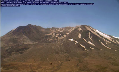
Take a look at the USGS "Volcano Cam" up at Mount St. Helens. This is a live camera that runs year round.  It is showing nearly 80 degrees up at Johnston Ridge.  That is worth the drive to see the mighty volcano that violently erupted 32 years ago. The devastation remains today.


Monday, July 15, 2013

This is get outside time!

This past weekend was spectacular. Saturday was mild with temps in the mid-seventies and Sunday warmed up to the mid-eighties. There was bright sunshine all around and wonderful outdoor opportunities. I took a ride over to Portland on Sunday to visit the Pittock Mansion. The view was awesome and the weather was perfect.

Our local weather professionals at the National Weather Service are indicating there will be a much of the same this week. I wrote more about the Pittock Mansion in my blog, The 'Couv' Life. Soak it up my friends, soak it up.