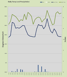
 Welcome to 2019! The first month of the year came in about 1-3 up over "normal" on both ends of the day. I had no real snow just a flurry or two on the 6th. Snowfall has been at a severe premium this season.Precipitation in general has been running well below established norms.
 This opening month to 2019 was pretty uneventful. No deep freeze, no major run dump, no snow other than a little flurry, no record breaking warmth, nothing really. Just 11 days with morning lows below freezing, but everyday managed to get above freezing. The mercury just stayed between 27° and 56° all month.
January 2019 saw the coldest temperature at a modest 27.3° on the morning of New Year's Day, one of those aforementioned 11 sub freezing mornings. Every single day last month managed to bust up over 40° with the chilliest daytime high a 40.6° mark that came on the 26th. On the warmer side of the spectrum we managed to see 11 days with the mercury topping out above 50° the warmest of which was a toasty 56.1° on the 23rd. Not a single night stayed above 50° the warmest overnight low was the 47.3° that occurred on the 23rd, not surprisingly the same day as the warmest high. January gave us 14 days with sunshine and just 10 days with rain, and technically one day with snow, but it was just a flurry and nothing stuck.
Precipitation was dry, again. We really need some rainfall and snow pack this year, holy cow. There were only 5 days last month that managed to spill more than a 1/4 inch of rain and the most came on the 18th with 0.65 inch. The 6th had a light and brief snow flurry I unofficially estimated at a 0.10 inch equivalent. Just 2.53 inches in the rain bucket which is less than half my 17 year average for January.
It is weird looking up at Silver Star in January and seeing such a light spattering of snow. This weekend starting on Super Bowl Sunday things might just whiten up a bit all the way down to the valley floors. If not to the valley, certainly below 1000 feet and that means the foothills will look proper again for this time of year. Ski resorts in the Cascades will certainly welcome more snowfall it has been dismal this season thus far.
The local weather prognosticators don't seem to know how big a shot we will get of colder arctic air. Most of the computer models seem to suggest it will be a mild shot thus the iffy stance on valley snow. One thing for sure is that we should see significant accumulations up higher in the 1000 foot plus areas. Right now it is raining and snow levels are pretty high like 5000 feet! Those levels will plunge as the weekend progresses. So it seems that winter may arrive late this year, we shall see.
Whatever the weather soak it up my friends, soak it up.
