Tuesday, December 1, 2020

Winter is Here... sort of.

November is done and December is here. Although the "official" start of winter occurs later in the month on the solstice, the real winter tends to start now. After all the next three weeks have shorter days than the last week of January on through spring. December tends to be our coldest month round these parts as well. So, winter is here, sort of. Temps have been seasonally chilly lately and so winter feels like it is ready for action. Let's take a peek at November's stats.

November was a pretty average month, rainfall was plentiful as should be in November but a tad short of my average for the month. No measurable snowfall was observed at my location. Temps were also pretty standard fare for November with the exception of a rather toasty day early in the month. On the 4th I recorded a 66.3° mark and a few stations in the area tickled 70° which is rather warm for the 11th month. The warmest temp was that 66.3° mark one of five days that breeched the 60 degree barrier. The coolest was a seasonally crisp 29.1° on the morning of the 8th, one three days under the freezing mark. The coolest afternoon high came on the 21st when the merc barely topped 40 degrees with a 40.5° reading. The warmest overnight temp arrived on the 4th with a summerish 59.5° bottom. November delivered 18 rainy days and just a pair of sunny ones. The wettest day was a 0.91 inch event on the 19th. The whole month saw 5.73 inches of rain. 7 days had more than 1/4 inch. 14 days failed to reach 50° but every day managed to get above 40° so it was a pretty unspectacular month overall.

December started off with nice sunshine and crisp but not cold temps and a bit of an east wind to add some bite to the air. The last month of 2020, will it go out with a wimper or a roar?

Soak it up my friends, soak it up. 


Sunday, November 1, 2020

Autumn in Full Swing


Autumn made its full entrance in October offering us a few Indian summer days along with our first general freeze over the area. It was a rather typical October in a very atypical and crazy year this 2020 has proven to be.

Temps rode the roller coaster but had a steady trend down all month long. That is just October round these parts. The warmest day was the 2nd of the month when I registered a 79.1° mark one of four days in the mid to upper 70s. Some other areas around the metro area recorded low eighties on the 2nd and 3rd. The coldest temp was a chilly 28.9° morning on the 26th one of two consecutive mornings in the 20s. On the 25th the temp struggled to get to the mid 40s topping out with an afternoon high of just 46.3° at my house. The evening of the 4th was very summer like with a low of a balmy 58.4°. 

Overall the month of October delivered 7 days with temps in the 70s all in the first half of the month, 21 days managed to break into the 60s and every day except one made it up to at least 50°. There were three sub freezing mornings all of which occurred in the second half of the month, eight days dipped into 30s. Nearly half the month however saw overnight lows in the summerish 50s.

October proved to be well below average for rainfall producing a mere 1.84 inches in my rain bucket. That is well below the typical four plus for October. The wettest day was the 10th when a solid 0.71 inch fell but that was one of only two days all month that could produce more than a quarter inch. I'm down 9 inches for the calendar year but the next two months are traditionally the wettest of the year so the potential for a "normal" rainfall year, at least calendar year, is still there but unlikely.

This is the time of year people start wondering about winter and what that might look like. Well, using the once every 5 years we get a "big one" snow event, we are due. The last time I recorded more than a foot of snow at my house was during the 2015-16 winter season when 14.30 inches fell. That was five years ago. The following year produced 10.95 inches of snow and there was a large event in February that year. More telling that we are due for a big event is the fact that I haven't seen a really big snow event since 2008 when we had that giant Christmas event dumping more than a foot and a half in December, the 2008-09 season was my snowiest at this location with 28.75 inches. I can't combine any two seasons since to top that total. We are due for a big snow event, so just keep that in mind.

Soak it up my friends, soak it up :)


Thursday, October 1, 2020

Summer ends Smoky and Wet: Hello Autumn!

What a wild September we just witnessed. Is it any surprise, what with this being 2020 and all? September was in some ways rather typical with daily average highs just a smidge above normal. A week of smoky conditions and warm temps that kept overnight lows in the balmy mid to upper sixties definitely kept the mean temp for the month well above normal levels. 

Early in the month a significant east wind event allowed a handful of "manageable" wildfires to get out of hand and merge into a giant ferocious, California style event. The east winds pushed the flames over the Cascade crest and down into the green side of the mountains. Even the Western side of Oregon and Washington get a little dry in September. Portland reported the worst air quality on the planet for at least two days during the smoke filled second week of the month.

Fortunately some good old fashioned late summer rain doused the flames and gave fire fighters some much needed help. The systems also helped clear out that nasty air that peaked above 500 on the air quality charts.

Temps were mostly mild, I recorded just one day above ninety degrees but PDX had four. The other three days landed just under 90° at my station. That left me with a typical seasonal total of 11 days above 90° for 2020 and no days over 100°. This is the third straight year with no triple digit temps at my station. Now those of you wondering about adding a ninety plus day in October, I have never recorded a 90° day in October since charting temps here in 2002. In fact my all-time high for the month is just 83.2°. So it is a safe bet that nineties have rode off into the sunset for 2020. One never knows however. 

The warmest daytime high arrived on the 3rd of the month with 92.2° the warmest overnight low was a toasty 67.6° on the 9th under blustery conditions that led to an invasion of fire smoke later that week. The chilliest temp was 50.6° mark on the morning of the 13th under a thick blanket of smoke. That led to a chilly afternoon high of just 61.9° on the same day. Oddly September came and went with no temperatures below 50 degrees! There were 12 sunny days but there were at least 5 more sunny days ruined by the fire smoke. A dozen days made it above 80° and that's a fair bit for September.

Rainfall at my location came in above average, but only by a few tenths. A win is a win, we have had sub-par rainfall nearly every month for the last few years. I registered 2.6 inches in the rain bucket with only 6 days showing any measurable precipitation. A nice fat 1.02 inch fell on the 26th. 3 days left at least a quarter inch of rain.

October is here and with it we should witness a precipitous drop in temps over the course of the month. I have no doubt some last gasps of summer may show up perhaps an 80° here of there, but that will come this week and not likely much further into the month. All of that stated it's 2020 and if we all know anything at all, it's that 2020 is nuts, we may hit 100° or maybe a blizzard will roll in for the kiddies on Halloween ;)

Soak it up my friends, soak it up.

Tuesday, September 1, 2020

Hot August Nights in the Northwest, Yep.

We just wrapped up a pretty typical August with my observed averages coming in a smidgen high than average on both highs and lows and a tad less than average on the wet stuff.

This is what we live for here, the best summer weather on Earth :)

Temps last month were very summery with August producing at least 70° every single day and nary a temp below 50° although one chilly night got close. Despite the above average temps for the monthly average we had about the normal number of hot days with three days pushing the merc into the nineties. More than half the month saw lovely days in the 80s and pleasant evenings with lows between 55° and 60°. 

The hottest daytime high arrived on the 15th when I recorded a 97.2° mark. The chilliest afternoon high occurred on the 6th with some showers and a 70.8° reading. The chilliest overnight low was a genuinely nippy for August, 50.1° on the 30th a reminder that Autumn lurks on the near horizon. The warmest overnight low arrived on the 16th following the hottest day when the merc dropped to a warm 67.5° overnight. 


On the 'water front'... No not the "Waterfront" the rain gauge! As is typical in August not much to see here. We had a few passing disturbances that caused some showers and even a little rain. Most of the wet stuff fell in the foothills and mountains of the Cascades. I manged to pick up a half inch for the month with two days gathering two tenths or more the most was 0.21 inch on the 6th.

Today is the first of September and round these parts it is the beginning of the end of summer. By mid-month we will start to feel that fall chill. It comes first in the evenings and then spills into the daytime highs. The average high temp on 9/1 is 79° and the average high on the 30th is 70°. Get ready friends it's about to get cooler, but first a message from our sponsor... Summer! It will heat up again this week and maybe even add another 90° day to our current total in 2020 of 10.

Get out and enjoy the last days of summer, soak it up my friends, soak it up. 

Saturday, August 1, 2020

July started slow but left no doubt about what month it is

July started out cloudy and threatening to continue June's late spring shower-fest. But as usual, July did in fact show up and it even got hot for a bit. After some sprinkles leading up to Independence Day, the last 28 of 29 days were bone dry save for that little sprinkle on the 8th. There was sunshine, there was heat but mostly there was glorious summer weather and that is why we love summer so in the Northwest.

My station had a few super hot days but nay did the high bust into the triple digits. My station peaked for the month on the 26th with a mark of 97.2°. Some local stations reported warmer temps even a few 100° marks, but not at my house. That scorcher was one of five days that managed to push the mercury over 90°. Thursday's 93.5° mark was the 7th day this year above 90° at my station. The overnight lows for July were well above average with 59.26° and the warmest morning low temp a nice and balmy 64.3° on the 30th. There's almost no point talking about the coolest temps but I mention them every month so here it goes: The coolest daytime high arrived on the 1st of the month with a pleasant 64.1°. The chilliest temp all month was the overnight low on the 25th when it dipped to a comfortable 54.2° Overall the daytime highs were just about spot on normal but the overnight lows were roughly 4° warmer than average. That made this July pretty warm by mean temp measurement.

The rain story was almost nil. A total of just 0.10 inch with half of it coming on the 8th. July is one of those months that doesn't really need to hit the average mark. July is routinely California dry. The average July precipitation of 1.02 inch is skewed by those occasional July storms that dump 2 inches in a day every few years. This was a typical July for rain.   

August is here and today is lovely with nice 80s and sunshine. Lets do it again Summer and just soak it up my friends, soak it up.

Wednesday, July 1, 2020

Soggy June, Hello July

Yes we had a wetter than average June my friends and by a pretty soggy margin. I measured 3.63 inches of the drippy stuff compared to the more typical 2.47 inches in June. Full disclosure there were a few systems that came through and dropped large amounts of rain and other areas around the metro may have had more or less. But the sun was certainly not in abundance last month. June is not typically a sunny month anyhow. The curse of the Rose Festival Low tends to wreck half the month. This year it was more or less around all month long.

The temps were about spot on average for June with slightly warmer overnight values. These higher lows came largely due to an abundance of cloudy nights. The warmest day was a toasty 90.4° on the 23rd, the only time I saw a ninety in June, and only the second such mark all year. It was also a daily record high for the date. The coolest daytime high was a early spring like, 57.2° on the 5th. Overnight the warmest was 61.9° on the 23rd which led to that lone 90 plus later that day, and was one of 6 days with overnight lows in the 60s. The chilliest temp came on the 1st with a 49.3° reading one of two nights that couldn't stay above 50. June gave us 16 days with temps above 70° five of which were above 80° including the lone 90.

June managed to stay mostly cloudy with just 5 sunny days all month. 10 days featured rain the heaviest of which occurred on the 7th when 1.13 inches fell one of two days with more than 1/2 inch. There were 6 days with more than 1/4 inch of rain. Over all June was definitely a lot more spring than summer and that is typically the case with June.

July is starting off a bit like June ended, but even if we have a sub-par summer, July and August will have abundant sunshine and gorgeous warm days lie ahead.

So get out and soak it up my friends, soak it up.


Monday, June 1, 2020

May Felt Chilly, but it Wasn't

This last month was a bit cloudier than normal and I think that led me to "feel" like it was a chilly May. it wasn't in fact it was quite the opposite. Overnight lows averaged a balmy +3° and daytime temps were slightly warmer than average. It was a about normal for the rain bucket as well with a little less than my average of 3.25 inches. May ended with thunderstorms over the weekend resulting in enough rain to push my station to near normal. June begins with the warm rays of El Sol, but don't be lured in by the Siren of Spring, T-storms and showers will return.

On the temps the chilliest measure I got was a nippy 37.5° on the morning of the 4th. The coolest afternoon high was 56.4° on the 14th. I did mange to top 90° for the first time in 2020 when the merc produced a warm 90.7° on the 28th. The warmest overnight low was a a rather summer-like 59.4° on the 29th of course following the month's high. That 90.7° mark was the only day that manged to reach into the realm of "hot" aside from that day the month produced four additional days above 80° and a total of 10 days above 70°. There was just the one morning under 40° but there was ten more that dipped into the 40s.

May produced 3.00 inches of rain at my station measured against my typical 3.25 inches. The wettest day was 0.39 on the 15th which was one of six days with more than 1/4 inch. We had 15 days with measurable precipitation and 4 days of mostly sunshine. In a nutshell, that was a warm and cloudy month.

June is here and miss spring will fight hard to dazzle us with her moody attitude but in a few weeks the glorious summer will arrive delivering weeks on end of beautiful sunshine that should shine upon us with little interruption until mid-September.

Get outside keeping your distance of course, and soak up the sunshine for the next few days. Look at all that glistening snow on the high Cascade peaks. Yes indeed soak it up.


Friday, May 1, 2020

April Warmer and Drier than Average

April is in the books and it was a couple of degrees warmer on both ends of the daily observations. I had a mere 1.81 inches of rain in the bucket, no snowfall, and frankly a nice April.

I am a bit nervous about the rainfall totals as we started off with a wet January but are now again trending down. I'm running at -6.34 inches for the calendar year thus far.

Temps were surprisingly flat for April which is a month that typically rides the spring roller coaster. There was one classic spring 'coaster' moment following the monthly high of the warmest day; a beautiful 75.1° on the 17th under lovely sunshine, the 18th had a high of just 53° at 22.1° plunge. The coolest daytime high was a chilly but not cold for April 47.2° on the first of the month. The coldest morning low arrived on the 13th with a cool 35.1°. Outlying areas saw frost. The warmest overnight low was a moderate 51.2° on the 29th. April gave us 20 days at 60° or better, 3 days failed to hit 50°, and we had 4 days at 70° or more.

The rain bucket wasn't busy last month with just 8 days of rain against 11 days of sunshine. Just 4 days saw a quarter inch or more rain. The wettest day was the 5th of April with a 1/2 inch of rain. I'm a bit nervous about the mountain snow pack. Silver Star Mountain (4364') has barely any snow at all and that suggests that mid-elevation snow is well below average.

That snow pack provides ample water through the dry season for both hydro-electric power generation as well as keeping it green through mid-summer. Green is good as it helps shorten the fire season and keeps things extra pretty during our glorious summer. Higher up int he mountain Timberline at 5900 feet is reporting 128" of snow pack which may seem like a lot but not really.

I posted the final snow fall report on the website here. Snowfall in May is highly unlikely so my official 2019-2020 snow season is well below average at 5 inches. That said mountain snow can and routinely does fall in May and even June so there is still hope to pad those pack numbers before summer.

Friday, April 3, 2020

Warm Winter Lead to Cold Spring ? !

January 2020 was one of the warmest on record round these parts but Winter was apparently napping and woke up when spring was tapping on his shoulder. March was nippy to say the least and even brought more snow than the rest of the winter combined.

Now this past March wasn't the coldest I'v seen and certainly no records were ever in jeopardy. But it was a chilly March that managed to deliver three inches of snow which surprisingly was more than any of the "winter" months this season. Yes technically March 20 is the end of winter but most of the weather guys start doing the 'spring thing' on March 1.

Temps were a couple of degrees cooler top to bottom on average last month and rainfall was below average.

Temps rode the roller coaster like we expect in March with a balmy 65.8° on the 20th that was one of three days to punch through the 60 barrier. It is not at all uncommon to get a seventy or two in March, no such luck at my station this year. The chilliest afternoon high was a nippy 38.7° on the 14th which was accompanied by 3 inches of fluffy white snow. The coldest morning came on the 17th at 30.7°. The warmest overnight temp was the 46.7° mark on the 29th.

Wet precipitation was scarce for March producing only 3.74 inches of rain well below my typical 5.52 inches. Snowfall was above average for March but snow is not exactly a thing for us in March the total for the month just a tad above 3 inches which is more than triple the "normal" for March. In fact snow is rare enough in March that the 3 inches that fell made it the second snowiest March in my 19 snow seasons at this location. The record was a whopping 7.85 inches in March 2012. It also was enough to measurably move my 19 year average from 0.82 inch all the way to 0.94 inch.

Well enough about frozen precip, the wet form came in a typical constant series showers with the wettest day producing a mere .55 inch which was also the snowy day so the "wettest" really was the 29th when some t-storms dropped 0.31 inch of rain. Only 7 days saw more than a quarter inch and a total of 19 days with precipitation. Aside from the extra snow, this was actually a typical March now that I really ponder it :)

April has started off a bit chilly but this could be the month we turn the corner into "real" spring. Snow levels are still sagging down under 2000 feet which is pretty low for APRIL.

I wouldn't mind seeing some temps later in the month tickle the 80° mark so we can punch that corona virus in the face. I don't know if warm weather helps, but I guess we shall see and some nice summer like weather might cheer everyone up a bit :)

I normally tell you to soak it up, but maybe staying inside a wee bit longer is wise advice.   

Sunday, March 1, 2020

Spring is here...almost.

The meteorologists consider March 1st the beginning of Spring but the "official" first day of Spring falls on the Spring Equinox which is March 19th this year. I have had a some issues with the network server updating my weather stats online. My station is fine but my charts and such are all messed up. I'll have to get it all sorted or buy a new Raspberry PI server. In the meantime, February was below average for rainfall, a tick above average on temps, well below average snowfall. The snow levels have been riding the roller coaster all month. Today the sun peaked out to reveal a heavy winter coat across the Cascade foothills down to about a thousand feet or so.

I didn't have any real cold weather with just ten days that dropped below freezing. Every single day except the 4th, managed to hit at least 40° and the 4th topped out at 39.7°. I recorded 0.5 inch of snow on the 3rd but it was only on the ground for a couple hours. This year looks like it will finish well under typical for snow. March however, can and has recently delivered some snowfall so I could pad the numbers a bit. It is highly unlikely I'll get over 6 inches this month so below average is the smart bet for this seasons snowfall. For the record, I did record 7.85 inches of snowfall in March of 2012, so it is possible ;)

I had no serious challenge to any of my local record lows, but I did record a local record daily high on the 6th with a 57.8° mark. Precipitation was weak sauce for the whole month with the wettest day being a 0.61 inch performance. We need some rain, we do.

February, 2020 had a bonus day but the rest of the month was rather average really. March could go any which way, March is a month that flies by the seat of its pants with winter and spring tugging at the weather. Could be cold, could be wet, could be warm, could dry, could be all of those things :)

Soak it up my friends, soak it up.


Saturday, February 1, 2020

Warm and Sopping Wet Start to a New Decade!

The real "news" about January 2020 as far as local weather was the rain. Yes, winter in the Northwest tends to be a bit drippy, but we outdid ourselves last month with a solid bucket of rain nearly 9 inches deep. But soggy conditions were not the only story. It was downright balmy at times with pineapple express conditions. I had a few personal record highs and even a couple of record warm low temps!

All of this sub-tropical warm and wet was even countered with a little bit of winter in the form of a couple of weak snow producing systems that passed through mid-month. What a weather month!

Keeping with my monthly reporting tradition I'll start with temps for January. Overall the month was relatively warm, seriously warm. The average overnight low was 6° above my established normal and daytime highs averaged nearly 4 above. The warmest daytime high temp arrived on the 31st when my merc hit 59.2°, other areas around the metro were above 60°. That was one of 11 days that managed to break into the 50's and one of 4 days to set local daily record highs last month. The warmest overnight low came on the 31st as well when the mercury barely dipped below 50 with a 49.8° mark that is a daily record warm minimum temp for me. It was one of 7, yes SEVEN daily record warm minimum temps last month! On the cold side of the equation there wasn't much to talk about and no daily record lows or record cold highs were even remotely challenged. The coldest morning came on the 15th with a 30.9° mark, yeah, above 30 degrees for the coldest temp in JANUARY! That was one of only 2 days below freezing all month long. This is also only the third time I have recorded a January with a coldest low above 30°. The coldest daytime high arrived on the 13th when the merc topped out at 37.9° and wintry mixed precip was about. I can't overstate this rather warm January. 17 days had low temps above 40°. This has been the warmest 'mean temp' January I have had dating to 2002. In fairness, when you see the precipitation results below you understand why that happened.   

Before I mention the precipitation totals, it should be noted that the wettest months of the year in this area are typically November and December. Those two months average at my house close to 8 inches each. January and February are wet, but typically average closer to 7 inches. January 2020 manages to put 8.94 inches in the bucket, not a record, but genuinely wet. January 2020 was my second wettest January dating to 2006 when I had 11.43 inches in the bucket and narrowly edging out January 2008 when 8.93 inches fell.

The incriminating factor was the fact that I measured precipitation on every single day in January. Officially I had 29 rainy days because I don't consider less than 0.04 inch of rain as "rainy." It is also notable that I did not record a single sunny day. Yes a few times the sun cracked through for a couple hours, but the whole month was all about those Northwest clouds and their innate ability to trap warm air at the surface. I measured 15 days with a 1/4 inch or more or rain, 4 days above a 1/2 inch and two of those were over one inch. The rest of the month was a seemingly relentless drip from above. The wettest day came on the 25th when I measured 1.25 inch of rain. Snowfall was below average for January but snowfall in this area is a bit fickle. I had 6 days with snow in the breeze but only two of those produced any sticking snow and both of those events were light and short lived. The most sticking snow I received was about 0.75 inch that lay on the ground on the 17th and was all but deceased by lunchtime. That whole period from about the 12th through the 17th was a "snow warning" that really never materialized below 500 feet of elevation and really was limited to high elevations above 1000 feet. I did receive a total of 1.29 inch of snow but of that only 1.25 inch stuck on the ground.

Looking ahead to this month we were rather toasty warm last night when at 12:01 AM my thermometer was at 59.2° following yesterdays high at 11:59 PM. The temp started falling overnight and continues falling to this moment where I now stand at 47.7°. The NWS seems to think that cold air will infiltrate our region over the next two days and snowflakes may start flying again tomorrow. We shall see. February is typically our transition away from wintry weather but it is no stranger to heavy snow and locals may recall that three of the last six Februaries brought significant snowfall and led all months those years in snow totals. For me at my station, February 2014 had 11.10 inches, February 2018 had 8.50 inches, and last February had 7.50 inches. You never know when it's gonna snow. If February passes without any snow, March is also no stranger to wintry weather, but I have only had one March that had a lot of snow and that was in 2012 when 7.85 inches fell. In short, it is still winter and very well may continue to be winter for the next 4-8 weeks. Only time will tell.

Soak it up my friends, soak it up.


Wednesday, January 1, 2020

Happy New Year!

Well 2019 is toast and we are now marching into a new decade. December weather wise went out with a bit of a warm whimper.

December had no really cold mornings and daily averages were about 3 above normal on both ends of the day. We had a month filled with clouds and rain which is typical, but the amount of rain was still only about 65% of normal at my locations and similar results were measured around the metro area. Had it not been for a light round of flurries very late on November 30th that carried over to December 1st in the early AM I would have had the first December in five years with zero snow. As it was the snow was barely measurable and did not make it to sunrise.

We do really need some epic levels of precipitation. The last several years have been sub par on rainfall. I hope this new year provides some needed rain and snow.

Temps were not drastic on either extreme just a bit warmer on average overall. The average overnight low came it at a warm 36.95° more than 3° above normal and the average high was nearly equally warm at 46.25° nearly 3° over. The coldest overnight low was 28° on the 26th, which is a garden variety value for a cloudless night in December. Yawn. That was one of only three nights under 30° and just seven nights with freezing temps. The warmest overnight low was a shocker when the merc manged to stay above 50°, yes FIFTY degrees for the low. That occurred on the 20th when the thermometer bottomed out at a balmy 50.2° which ultimately led to the warmest day of the month when it reached 56.3° later in the day. The chilliest afternoon high was a crisp 38.5° on Christmas Eve which as it turned out was the only day that failed to reach 40°. December had four days that manged to push the red line into the 50's.

Overall we did not even come anywhere near any daily record lows nor did we come anywhere near the coldest daytime highs of Decembers past. It wasn't that the temperature was excessively warm last month, it was on average three degrees, it was just so consistently warm rather than a bunch of extremes.  It was simply warm for December, the whole month. I did set one local daily high temp record on the 20th when that 56.3° temp was recorded.

The precipitation side of last month was equally boring. We had one pineapple express event that dropped nearly half of the month's rainfall over a three day period from the 19th through the 21st during which 2.48 inches fell including the wettest day of the whole YEAR at 1.02 inches on the 21st. December yielded 9 days with over a quarter inch of rain and 14 days with measurable precipitation. The aforementioned snow was barely measurable with a total of just a few millimeters on the early morning of the 1st that briefly accumulated to about 0.1 inch.

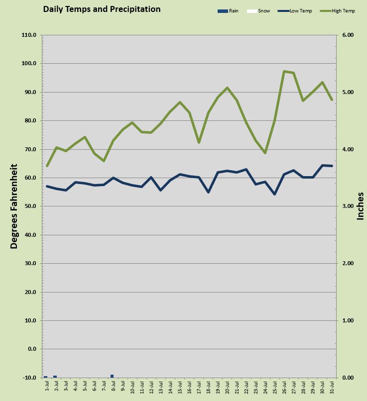
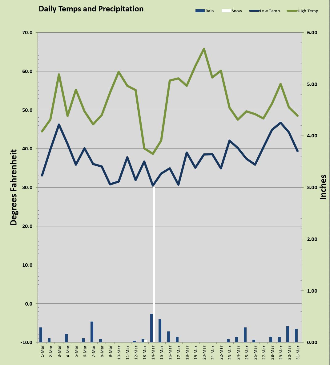
The year ended with 138 sunny days, 107 rainy days, and 14 days with snow or ice. On the cold side we had 59 sub freezing mornings, 3 sub 20° mornings, only 13 days that failed to reach 40° and every single day in 2019 manged to make above the freezing mark by afternoon. The coldest overnight low was a chilly 19.4° and the coldest daytime high was 34.5° both of these were in March! A total of 8.3 inches of snow fell with nearly all of it coming in February. That snow total was a tad under my 19 year average. Rainfall for the calendar year of 2019 (rainfall is typically measure seasonally from September to August), was only 26.63 inches about HALF of my local normal of 53.36 inches. It's time for us all to do a rain dance, we need it!

On the warm side of things, we had absolutely no days at 100° or more, and only nine days that busted into 90s. 190 days managed to climb to 60° or more, and the hottest temp was 98.8°. The warmest overnight low was a warm and cozy, 65.5°.

We have a fabulous northern maritime climate here that just tends to avoid the extremes. 2019 was no exception. Think about this, 237 days in 2019 saw overnight lows of 50° or more. That is 2/3 of the year with toasty warm lows! 190 days in 2019 saw high temps at or above 60° which is more than half the year!

Looking forward into 2020 we are starting off mild with today's temp already tickling the 50° zone. Weather pros however are watching closely at things over Alaska. That notoriously cold state has been experiencing some of the coldest weather in a decade. The jet stream could make a correction and drag a bunch of that hyper frosty arctic air over the top of us and things can get wintry really fast. Happy New Year!