Wednesday, December 1, 2021

Warm and Wet in Mid-Autumn


That title sums it up well, in fact this may be the warmest November I have on record, after 20 Novembers at this location. But this wasn't sunshine and hot levels of warm and in fact the all time record high for me at this location wasn't even close to being challenged. But it was consistent balmy for most of the month with a continue pipeline of war and wet systems dropping copious amounts of rain. It has been a long while since we had a proper Western Washington November, and this was it, although it was warmer than normal by a substantial mark. You may notice I have begun highlight warm and cold records on my chart that accompanies this blog post each month. Warm being red and cold being blue.

My twenty year average low and high for November is 38.85º L and 51.34º H. Last month it was 43.46º L and 54.89º H. Yes you read that right plus 5 and plus 3 respectively for the month. What was particularly interesting was the fact that I had 11 daily records fall, all on the warm side. Eleven daily records in ONE month is more than just unusual. I had 7 daily high records broken on the 13th, 14th, 15th, 27th, 28th, 29th, and 30th. The warmest of these was the monthly high mark of 65.7º on the 14th, well off my November record of 72.1º. I also had 4 daily record warm minimum temps. That is the overnight low being warm. Those occurrences were the 11th, 14th, 29th, and 30th. The warmest overnight low last month came on the 14th when the mercury dipped to just 58.9º. A few miles away at PDX the overnight low that night was above 60º in MID NOVEMBER! The month was not entirely absent of chilly temps however. I dod have a 3 sub-freezing mornings the chilliest of which was a mark of 29.7º on the morning of the 22nd. No daily low records were so much as challenged. The chilliest afternoon high was a rather typical 45.3º on the 21st. November delivered just 3 sub-freezing temps and only 8 nights dipped into the 30s. That's nuts! 

November gave us just 1 sunny day and the rest were partly cloudy of overcast. 21 days of rain which isn't that unusual for November, but a bit gloomy none-the-less. Not a lick of snow fell but snow levels did come down to 1500 feet a couple of times. I had 8 days with more than a quarter inch of rain and 2 days with more than an inch including the wettest day of the month, the 12th when 2.01 inches fell. The total rainfall came in a tad under the historical average but still managed a solid 7.32 inches in my bucket.

Today it is a nice sunny afternoon and sitting at about 55º so December is off to a warm start as well. But December is when things tend to get chilly, so we shall see if Captain Balmy continues to rule.

Thursday, November 4, 2021

Here Comes the Rain Again...

God finally opened the spigot and October was actually a little wetter than average. Overall the month was pretty solidly average with no wild swings in temperature or precipitation, just a happy go lucky welcome to Autumn.

As of today, November 4th, there has still not been a sub-freezing temperature this season. That is not exactly rare, but maybe a tad uncommon for my location at this point in the fall. October did produce a couple of frosty mornings and three evenings in which the mercury dipped into the 30s. The lowest mark of 36.9º was hit on the 12th. The chilliest afternoon high was a rather seasonable 53.4º also on the 12th. At the other end of the mercury, the warmest temp last month was a mark equally seasonable for the start of October, with a 70.9º reading on the 2nd. The warmest overnight low was an almost summer like 55.4º measured on the morning of the 4th. October delivered a single day over 70º and 17 days at or above 60º so the temps played "normal" all month long.

On the water side of the weather, we also had a fairly typical amount of rain for the month. Lately we have been underperforming on precipitation, so it felt like a deluge or rain when in reality it was just a proper October. There were 17 days with rain ranging from very light showers to the heavy 1.01 inch received on the 22nd. 4 days produced a 1/4 inch or more in the rain gauge with 3 of those exceeding a 1/2 inch. October managed to provide just a 2 sunny days but one of them was on the very last day so the kiddies could trick-or-treat under clear skies.

November is following along with October's game plan so far. temps should start to get chilly as Thanksgiving approaches. Multiple frosts and freezes are likely unless November decides to rain every day, which could happen ;) Snowfall in November is not really that common. Outside of a random flurry or two, I have only had 4 Novembers in the past 20 with more than an inch of snow. The most snow I have recorded in November is 3 inches in 2003. The last time I had an inch on the ground in the 11th month was back in 2014. So methinks we won't see much in the winter precipitation until perhaps next month.

Friday, October 1, 2021

Warm and Wet to end Summer

September was warm a few degrees above average at both ends of the day. It was also rather wet offering up the first "real" rainfall in months. Once daily record high for my station was posted and a daily record 'warm' overnight low as well. There were no freakish heat waves and no real pre-autumn freezes, just a typical September with a bit warmer temps and double the normal precipitation.

The month gave us us a maximum high of 87.5º late enough in the month to be a daily record. That was the 24th. The warmest overnight low was a measure of 61.9º on the 8th. The chilliest temps were a morning low of 46.7º on the 16th, rather seasonable really and a mild afternoon high of only 61.3º on the 28th. September delivered 11 sunny days, 7 rainy days, and 11 days above 80º. 

The rain gauge was busy last month. although only 7 days were wet, that is a fair bit for September and a few of those days were soggy enough to produce more than a half inch. The wettest day was the 19th when God started thinking about Noah again... 1.68 inches in the bucket. The total rainfall for the month was a more October like 4.20 inches. Three days went over 0.5 inch including the 28th which nearly hit an inch at 0.93. 4 days had more than 1/4 inch. 

The High Cascades received their first dusting of snow during first wave of storms. Mt Hood and Mt Adams are wearing a winter coat proudly and even St Helens saw the rim dusted. Autumn is here and it feels like we might actually get some rain this season. I hope so, we have been below normal for quite some time. 

October should slide quickly from mild and comfortable to chilly by Halloween. That tends to be the case as Autumn settles in and our sweaters come out of the closet. Soak it up my friends, soak it up.

Wednesday, September 1, 2021

I Forgot July ! It's Two for the Price of One then ;)

Yes I completely failed to collect my data and post last month. That's OK I have it all collected now so I'll post two months of data this go round. I must have had residual heat stroke from the all time record breaking heat wave in June :)

So July was more or less an average month. I mean seriously, reads like a "normal" July with little in the way of temperature fluctuations other than being warmer overall than average. Sure we had few 90 plus days at the end of the month. Over all the chart is super flat on temps for the month. July had no measurable precipitation at all. This is not by any means rare, but it is unusual to have the entire month of July bone dry. July had a max high of 95.6º and a max overnight low of 70.2º. We don't get overnight lows in the 70s very often round these parts. The coolest daytime high was 74.2 which is just a few degrees under average. The coolest temp was an overnight low of 56.3º which is also just a tick under average. Overall July was warmer than average by about 4º both over night and daytime highs. The month yielded 23 sunny days, no rainy days, 3 days above 90º and 14 days with overnight lows above 60º.

August was more temperamental than July this year. Despite having two days above 100º the overall month was cooler than July by a couple of degrees. August saw little rainfall with just 0.18 inch at my station with three days having measurable precipitation. The warmest day was 102.4º one of two triple digit marks for the month the other a day earlier. Both century toppers were daily record highs. The warmest overnight low was 70.5º one of two overnight lows that stayed above 70º. The coolest temperature was a nippy 48.5º late in the month and the coolest afternoon high was 67.8º one of four days that failed to reach 70º. There were 12 sunny days, 3 rainy days (sort of drizzly really) 8 days above 90º and 20 days with lows in the 60s or higher.

September is looking pretty typical thus far. This is the month that usually begin our great Autumn slide from warm to cool. The normal daytime highs begin in the upper 70s and drop precipitously to bare 70º by month's end. September however is capable of delivering warm and even hot weather but heat spells this late in the season tend to be short lived and less aggressive than those in July and August.

Word on the street is a La Nina condition is building in the Pacific Ocean and that tends to lead us to cool and wet conditions with above average chances for heavy snowfall and low elevation snow. This could be an interesting winter season. 2009 I had an all time record high in July followed by an all time record low in December (record for my station). So who knows, right? We did have an all time record high this summer.

Thursday, July 1, 2021

June ends with a taste of Phoenix

One of the all time biggest weather events in the recorded history of the Pacific Northwest happened at the end of June. Locally it was one for the history books as well as the record books. It capped a rather tepid June with a 500 year heat event. This weather event cannot be overstated, records were not just broken they were utterly crushed as if the planet had suddenly moved into the same orbit as Venus.

This massive heat event locally is on par with the 1980 record snowstorm that laid down 44 inches of snow and left drifts in excess of six feet tall, the 1962 Columbus Day Wind Storm, the 1973 F3 Tornado, The 1950 Freeze with multiple sub-zero temps, and now the 2021 Heat Dome.

Although climate change has led us to see warmer trends over the last several decades this event is something else entirely. These heat domes according to scientists, only have about a 1 in 1000 chance of forming. These are rare events but when they occur they intensify the heat with pressure variants, pushing air downward to produce frictional heat through compression on top of the normal atmospheric heat generated in typical west coast heatwaves that are mostly based on off-shore flows bringing warmer interior air to the coastal areas. The interior portions of Washington state also saw record high temps but those records for the most part were only broken by a degree or two, our records were crushed to more than 10 degrees in some areas more than 9 degrees at my station here in Vancouver USA. CBS news had a nice scientific explanation of the phenomenon here.

To wrap your head around this event, Lytton, British Columbia set Canada's all-time record high temperature of 117º on Monday which is hotter than the all-time record for Las Vegas, Nevada! Are you kidding me... CANADA?

Locally in Vancouver, WA I broke my all-time record of 106.1º in 2009 on Saturday, June 26th recording a 107.1º temp. Sunday I recorded 111.1º further crushing the record, then on Monday I recorded 115.2º now nearly ten degrees over the previous all-time high! I hadn't recorded a 100º plus day in three years! This past weekend I recorded three in a row! All three days were records for the date and all three were all-time records until successively replaced each day. I also broke the all-time warmest overnight low record twice in row! Previously the warmest overnight low I recorded was a balmy 73º back in 2006 on the way to a muggy and showery 89º. Sunday morning the 28th I recorded a 73.5º breaking my all-time warmest overnight low then followed it up on Monday morning with a crazy warm 78.1º overnight low.

Prior to the heat dome event June 26th-29th, June was looking very... Juneish, with lots of clouds, a mix of sunny and warm with cool and showery, just like 'normal'. Then hell opened up a portal and washed the Northwest in a biggest heat event ever.

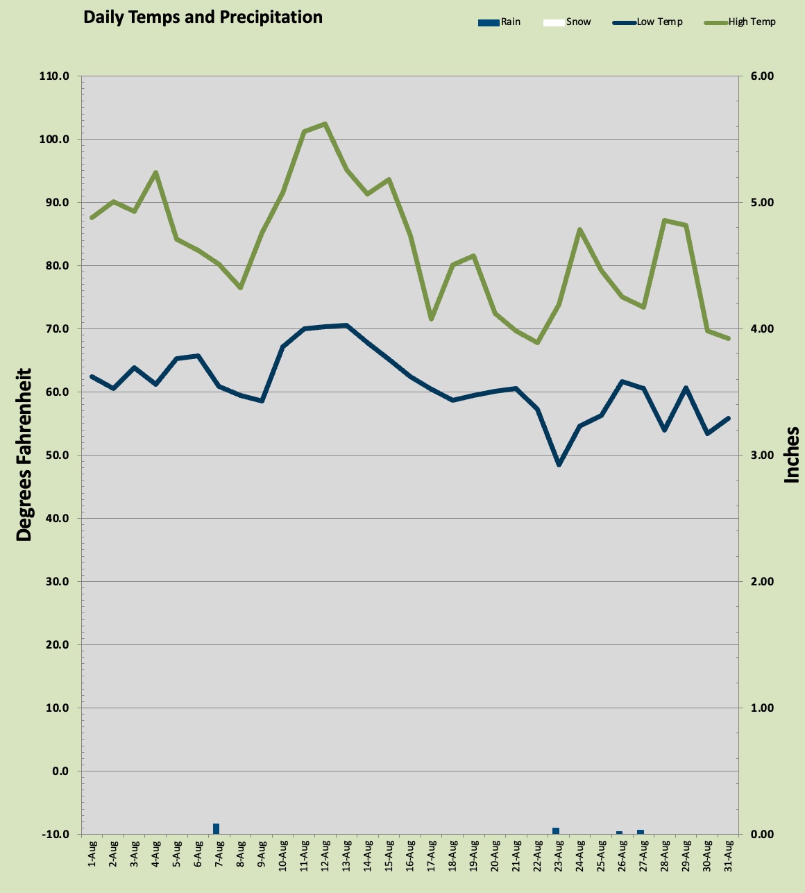
For the month I recorded eight days above 90º which is two thirds of the normal total for a YEAR. I had three days above 100º. It wasn't all heat wave though, I recorded 10 days that failed to make it to 70º, but everyday got above 60º. The coolest temp recorded last month was 48.5º on the morning of the 7th one of three days under 50º.

On the water side of weather we had a sub-par rain month in June but only by a small margin. June was below normals but close enough with 1.62 inches in the bucket about seven tenths under normal. most of the rain came in a two day event that dumped more than a 1/2 inch each day on the 13th and 14th. I measured .55 inch and .61 inch respectively. Those were the only days over .25 inch. We had 16 sunny days and 6 rainy days. 

Let's hope the rest of our summer is more typical for our area, you know the best summer weather in the world, 75-85º every day with warm but not hot evenings. Yeah that western Washington summer ;) I've had my fill of Phoenix. July is starting off cooler and even a bit cloudy. I'll take that.

Soak it up my friends, soak it up.

Tuesday, June 1, 2021

April Showers and May Flowers?

Last month I managed to forget to post the April results so I'll do double duty this month. April and May were both pretty average for temps with April a smidgen cooler than average and May a smidgen warmer. The story was more about precipitation and the LACK THEREOF. According to the local weather pros, the driest April-May combo on record. I measured just 1.36 inches for both months COMBINED! I typically see 7.49 inches across the two months. So dry is the word for mid-spring in Vancouver USA.

Neither month was anything crazy on any end of the extremes, there just were not any real extremes aside from being bone dry. The warmest temp in April was 82.9º and in May 85.6º with Memorial Day having the honor of the warmest day. The coldest morning low was 31.6º in April and in May it was 41.6º neither pressing on any records. The high temperatures managed to get above 50º every single day of both months. April had two days above 80º and May had five. 

Not much to talk about rainfall the wettest day was 0.29 inch on May 25th mostly from a heavy shower that also dropped some hail. That was the only day with more than a 1/4 inch in the bucket. April had a desert like 0.43 inch and May picked up the balance with 0.93 inch. Again, the driest April May combo on record not just for me but the metro area as well with records dating back 140 years.

Hopefully we will get the classic "Rose Festival Low" that haunts the Portland-Vancouver Metro area this year and get some much needed rain. Last season was really bad for wildfires in Washington and Oregon, this year could be worse. Same heavy rain in June could keep things dry through mid July to help stave off a really bad fire season.

So there really weren't any April Showers to bring those May Flowers, but honestly around these parts the flowers come a bit early anyhow :) Soak it up my friends, soak it up.

Thursday, April 1, 2021

Marching into Springtime

That title is no fool, friends; March did usher in our first springlike weather and also had a few chilly bits just to remind us were are still above the 45th parallel.

I recorded both my first 60° high and my first 70° mark of the season last month. The sixty came on the 11th which was one of six days last month to bust out over sixty degrees. The lone 70 came on the last day of the month and just barely with a mark of 70.1° yesterday afternoon.

With all this sixties and seventies talk, what's with that bit above about north of the 45th? Well friends I had a daily record low fall at my station. On the morning of the 16th the mercury bottomed out at 29.7° which was the chilliest for that day since my records started in 2002. That was also the lowest temp for the month. 

March was rather mild this year. The warmest overnight low was 45° on the morning of the 19th and the chilliest daytime high was the 15th with a more February like 46.5°. All told March 2021 was pretty spot on average just a tad cooler by night and a pinch warmer by day. I recorded just three sub freezing temps and every single day managed to get above 40°. 

The rain bucket was not very busy last month. I measured a mere 1.57 inches of precipitation all of which was rainfall. That is well under the 5.52 inches average for me. There was some hail that came down in a few heavy showers. Snow levels rode the roller coaster up and down between 1000 feet and 5000 feet all month. The wettest day was 0.29 inch on the 22nd and that was the only day with more than 1/4 inch. I had 6 days of sunshine and 12 days with some rain. 

It looks like we are likely in the clear of winter precipitation as I have only recorded snowfall after March 31st on one occasion. In fact as I write this my thermometer is making a run at yesterday's 70 but it sits at 68.7° right now. I think that's all she has today.


Monday, March 1, 2021

Febuuurwary 2021.


February turned out to be mostly normal save for that one wild weekend at the Presidents Day/Valentines holiday. I saw a few daily records broken and even a month record over the 19 winters I have recorded at this location. That was fun. 

First let's talk temperatures. February on occasion can deliver some frosty temps but generally by the time the 2nd month arrives things are already starting to get a bit warmer. That big mass of arctic air that gave Texas the coldest winter temps ever recorded did not hit us near that hard. But I did have a few daily records fall, quite a few actually. The four days from the 11th through the 14th all recorded daily records for lowest maximum temperature. The 11th surprised me as the temp did get well above freezing, but anyway the daily highs were 36.1°, 28.1°, 33.1°, and 32.8° respectively all daily records for coldest daytime high. The all time coldest February daytime high in my 19 winters here is 22.2° back on February 6th, 2014. Although the heavy cloud cover all week leading to the snow event kept the overnight lows relatively warm, I did manage to muster two daily record lows on the 12th and 14th with 24.3° and 28.2° respectively all under cloudy skies. The coldest temp came on the morning of the 12th with that 24.3° of course nowhere near any monthly records. My all-time low for February is 14.7° and the official all time low dating back to 1950 is -3°. The coldest afternoon high also came on the 12th with 28.1° under snowfall. The warmest temp of the month was a nice 55.3° on the last day the 28th. The warmest overnight low came on the 21st when the mere only dropped to 43.6°. 

February delivered seven sub-freezing mornings and two days that failed to get above freezing at all. The month had five days that failed to make it to 40° but five days broke over 50°. Overnight lows were about dead average for a February but daytime highs stayed nearly 4° below average with lots of cloud cover.

The real news last month was the snowfall. We don't get many snow events with a foot or more of snow, but that is exactly what most of the northern part of the metro area got. I received a total of 12.5 inches over a four day period the bulk of which fell on the 13th. In fact 7.5 inches landed softly that day which is the single highest one day snowfall in February for my records. It however is well short of my all-time one day record January 6th, 2004 when I got 10 inches. It started aggressively snowing around 4pm Friday dropping the 7.5 inches by midnight that's almost an inch an hour! 

Overall precipitation was a tad lighter than average, with 4.78 inches about an inch and a quarter light. The wettest day was actually the snowiest day with roughly a 1.1 inch water equivalent. I had 6 days with more than 1/4 inch and 17 days with precipitation. This was a very cloudy month with just one day qualifying as "sunny" and barely so. Four days had frozen precipitation. During the snow event, there are all three types of winter precipitation mostly snow, but a bit of sleet and some freezing rain were in the mix as well.

March started of with temps approaching 60° and I am certain some areas topped 60°. Looking like a spring tease me thinks :) We shall see but I have not ever had a major snow storm in February followed by a big snow event in March. Winter isn't over, but I think Snowzilla is done for season.

Get out and soak it up my friends, soak it up.

Monday, February 1, 2021

2021, First Month in the Books

January was warm and wet, kind of warm, really wet. This winter has been very mild. If we don't get a late season arctic event we will end up as one of the balmiest winters in the last twenty years. 

Last month was rather wet and that typically translates into warmer temps. My observed averages looked more like November or February than January. 3° above normal for the lows and about 2° warmer by day. I had six days in January that broker above 50° and one day got super close to SIXTY! In fact the official measurements at both PDX and Pearson hit 61° on the 13th when I had 59.4° here. That same day resulted in the wettest one day rainfall of the season with 1.96 inches in the bucket. Yeah, that's pineapple express. I only had five days that recorded a freezing temp and everyday managed to get above freezing in the afternoon. The coldest daytime high was only a couple of degrees under the "normal" high, that was a 39.1° mark the afternoon of the 26th when the only snow of the month and season so far fell. It wasn't much. The warmest overnight low was 45° mark the morning of the 2nd. Every day save for two made it into the 40s. The coldest overnight low was a seasonably chilly 24.8° on the 23rd. There were eleven overnight lows that stayed in the 40s!

I mentioned pineapple express and that was the scene for most of the month with warm temps and buckets of rain. I measured 8.4 inches last month against the more typical 7 inches. The warm temps kept the snow levels high and the lower foothills saw mostly rain. Higher up the snow came down by the yard. The wettest day, the aforementioned 13th with a balmy 59.4° high and nearly 2 inches in the bucket. That was one of seven days producing more than 1/4 inch of rain of which five produce more than 1/2 inch and two over an inch. There were 24 days with precipitation. The only snow event was a paltry short lived 1/4 inch on the 26th. Most areas down low saw nothing stick and not much more than flurries, higher plains around 300 feet saw the light dusting hang around for an hour or so. Weak sauce. This is early yet in the second half of winter, so there's still time, but if no more snow falls this season it will be the least snowy since the winter of 2002-03. 

The outlook for the rest of winter is a bit questionable. Right now there is a dip in the jet stream sending heavy rain into California. Sometimes these dips can let cold arctic air invade the region. Over the last ten years we have had several cold events with heavy snow in the second half of winter. 

  • February 2011: 5.8 inches (9.4 inches total season)
  • March 2012: 7.9 inches (14 inches total season)
  • February 2014: 11.1 inches (12.9 inches total season)
  • February 2018: 8.5 inches (11 inches total season)
  • February 2019: 7.5 inches (8.3 inches total season)
  • March 2020: 3 inches (5 inches total season)
You can never really tell for sure, so we will just have to see. Soak it up my friends; soak it up.

Sunday, January 3, 2021

Happy New Year!

Another year is in the books, this past one won't be missed much. Weather wise it was business as usual with a couple of twists. before the year end summary here's a look at the final month of 2020.

December was warm and wet, but not as wet as normal. The temps were definitely on the Northern California warm side with a monthly observed average low of 36.94° nearly 4° warmer than my 19 year average and the observed highs a toasty average of 47.68° also about 4° warmer than my average. Yikes more like November! The coldest temp was a nippy 25.6° on the morning of the 29th which was one of only seven sub-freezing days all month. The warmest day was a mark of 58.8° on the 21st which is a daily record for me. Locally the NWS observed a 61° mark that day at the airport also a record. The coldest daytime high a rather typical 39.8° on the 29th under foggy conditions. The warmest overnight low was a balmy 48.4° on the 19th which was another record for me locally, the NWS reported a 51° that night at the airport. The month yielded only nine days with lows under 40° and that is just CRAZY! There were also nine days with highs in the 50s which is pretty nutty for December.

With those warm autumn like temps it should come as no surprise that nary a snowflake was seen last month. Not so much as a flurry. Rain came heavy at times but not enough to hit the average. I saw 6.34 inches measured against my 'normal' of 8.02 inches. There were 10 days with a 1/4 inch or more and two days with more than one inch. December had 19 rainy days and 4 sunny days which is actually pretty typical. The wettest day was the 21st which was the second day in a row over one inch with 1.12 inch falling. 

Looking at the annual numbers for 2020 nothing really bizarre to see. Although snowfall is measured on a seasonal basis the colander year total was sup par at 4.84 inches all of which fell in the first half of 2020. The hottest day of the year was 97.2° on the 26th of July that was also a local daily record at my station. This was the third year in a row that I failed to record a triple digit temp. The NWS reported an over 100° mark however at the airport that day. The coldest temp was rather oddly last month despite its warm characteristics no low temp in 2020 was colder than the 25.6° on December 29th. Perhaps 2020 was a warm year? I think it was actually. Only 30 days saw subfreezing low temps which is about half of a typical year. There was nary a single day under 20° and every single day in 2020 managed to get above freezing. I got 40.15 inches of rain which is about 80% of my local 'normal' and that aligns with other reports in the area. I had 146 days with precipitation of which 62 had more than a quarter inch. There were 96 sunny days which is low even for us since I count 'mostly sunny' as 'sunny'. We had 194 days with a high temp at 60° or more. So how was 2020 as far as record warmth... well I observed the highest average low temp of any year in the last 19 years. But the average observed daily high was in the bottom half of those years so the mean temp in 2020 was pretty average overall. There just wasn't any real weather events aside from a strong wind storm that caused damage and managed to enrage a few wildfires and cause dangerous air quality in September. 

So 2021 is starting off like December ended, warm and wet. This just might be one of those winter seasons that produces no sticking snow. I haven't had one of those since the winter of 2004-05. Take a look at the charts below.