Saturday, August 1, 2020

July started slow but left no doubt about what month it is

July started out cloudy and threatening to continue June's late spring shower-fest. But as usual, July did in fact show up and it even got hot for a bit. After some sprinkles leading up to Independence Day, the last 28 of 29 days were bone dry save for that little sprinkle on the 8th. There was sunshine, there was heat but mostly there was glorious summer weather and that is why we love summer so in the Northwest.

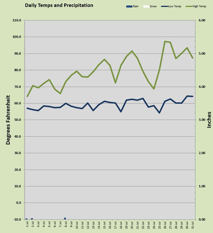
My station had a few super hot days but nay did the high bust into the triple digits. My station peaked for the month on the 26th with a mark of 97.2°. Some local stations reported warmer temps even a few 100° marks, but not at my house. That scorcher was one of five days that managed to push the mercury over 90°. Thursday's 93.5° mark was the 7th day this year above 90° at my station. The overnight lows for July were well above average with 59.26° and the warmest morning low temp a nice and balmy 64.3° on the 30th. There's almost no point talking about the coolest temps but I mention them every month so here it goes: The coolest daytime high arrived on the 1st of the month with a pleasant 64.1°. The chilliest temp all month was the overnight low on the 25th when it dipped to a comfortable 54.2° Overall the daytime highs were just about spot on normal but the overnight lows were roughly 4° warmer than average. That made this July pretty warm by mean temp measurement.

The rain story was almost nil. A total of just 0.10 inch with half of it coming on the 8th. July is one of those months that doesn't really need to hit the average mark. July is routinely California dry. The average July precipitation of 1.02 inch is skewed by those occasional July storms that dump 2 inches in a day every few years. This was a typical July for rain.   

August is here and today is lovely with nice 80s and sunshine. Lets do it again Summer and just soak it up my friends, soak it up.

Wednesday, July 1, 2020

Soggy June, Hello July

Yes we had a wetter than average June my friends and by a pretty soggy margin. I measured 3.63 inches of the drippy stuff compared to the more typical 2.47 inches in June. Full disclosure there were a few systems that came through and dropped large amounts of rain and other areas around the metro may have had more or less. But the sun was certainly not in abundance last month. June is not typically a sunny month anyhow. The curse of the Rose Festival Low tends to wreck half the month. This year it was more or less around all month long.

The temps were about spot on average for June with slightly warmer overnight values. These higher lows came largely due to an abundance of cloudy nights. The warmest day was a toasty 90.4° on the 23rd, the only time I saw a ninety in June, and only the second such mark all year. It was also a daily record high for the date. The coolest daytime high was a early spring like, 57.2° on the 5th. Overnight the warmest was 61.9° on the 23rd which led to that lone 90 plus later that day, and was one of 6 days with overnight lows in the 60s. The chilliest temp came on the 1st with a 49.3° reading one of two nights that couldn't stay above 50. June gave us 16 days with temps above 70° five of which were above 80° including the lone 90.

June managed to stay mostly cloudy with just 5 sunny days all month. 10 days featured rain the heaviest of which occurred on the 7th when 1.13 inches fell one of two days with more than 1/2 inch. There were 6 days with more than 1/4 inch of rain. Over all June was definitely a lot more spring than summer and that is typically the case with June.

July is starting off a bit like June ended, but even if we have a sub-par summer, July and August will have abundant sunshine and gorgeous warm days lie ahead.

So get out and soak it up my friends, soak it up.