Showing posts with label temps. Show all posts

Thursday, March 1, 2018

The Big Switcheroo!

Yes friends old man winter pulled a sneaky switcheroo on us this year. January and February seemingly switched positions. January was a warm month even by February standards with several daily highs broken, no snowfall and only a couple of days that dropped below the freezing mark. Kind of like February with wafts of spring. Then the real February showed up and within a few days it became clear the switcheroo was in play.

Although my average daily low temp for last month was still a bit warmer than an average for January it was close to spot on average for February. The average daily high last month was 3 degrees below my 17 season established "normal." The real switcheroo was the snowfall. I had a one inch dusting on the early am of Valentines Day that melted away in the afternoon and then some frisky cool air came in a few days later and I saw an inch on the 18th, a little dusting on the 19th and a bit of an on again off again 4 inch event on the 20th followed by two more days with an inch or more. 8.5 inches of snow in February is WAY above my 17 year average of 1.71 inches. In fact this is only the second February I have ever measured more than 6 inches for the month. 8.5 inches is second only to the crazy 11.1 plus we got back in February 2014.

I did have one daily record low on the 23rd when I awoke to a crisp 21.9 degrees. That was a record for me and for a number of areas around the metro. Early February has seen temps historically below zero with the record for the month at a Minnesota -3° back in 1950; but this late, the 23rd, 21.9° is legit chilly and it turned out to be the coldest temp of the month.

February seemed like a cold one with the above average snowfall, but the heavy cloud cover all month long actually kept things pretty warm, relatively speaking. Average low came in at 35.19° which is spot on my 17 year average and daily high average 46.69° well below my established norms. The warmest night was a toasty 47.8 on the 4th and the coldest daytime high was 33.8° on the 20th and it was accompanied by the 4 inches of snow. That day never had more than 3 inches on the ground as it snowed in two separate events about 2 inches in the morning, followed by mixed precip and some melt off, then another 2 inches later in the day. There were 8 days where the temperature managed to bust out over the top of 50° and we got close to a sixty when it was 58.8° on the 7th. We had seven days where the mercury could not push to 40° That turned out to be the week we had the snow and those low temps kept some snow on the ground for a week. The month ended with 9 days with a low below freezing and the aforementioned 7 days that failed to reach 40°

As for the precipitation it was cloudy but kind of dry really. Sure we had 8.5 inches of snow, but he water total in the bucket came in at only 2.07 inches and that is about a third of a typical February. We had 13 days with rain, 6 days with snow, but the wettest day was a paltry .36 inches. That was one of only three days to dump a 1/4 inch or more. We need more water down here and snow up there!

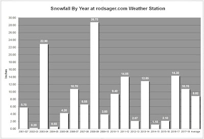
So March will once again be the wild card. Will it be an early spring or late winter? Today it is a bit of a tease as I am looking out the window to partly cloudy skies with peek-a-boo sunshine and a temp of 46.8° at 11:30am. Who knows, March can go either way. As it stands now this winter season is in a dead heat tie for 6th place on my annual snowfall chart with 2006-07 10.70 inches. Any amount of snow that falls before summer will knock 2006-07 into 7th. Over my 17 seasons of snowfall every February with 5 or more inches of snow has lead to a March with little or none. As it stands now I'd have to give the tie breaker to the 06-07 season as I had 19 days with measurable snow and a whopping 39 days with at least a trace of snow still on the ground. That crushes this season's totals of 9 days with measurable snow and 15 days with a trace or more on the ground. We only need a tickle to bump them, but it's just a silly snow chart, right?

Soak it up my friends, soak it up.
Tuesday, January 2, 2018

Happy New Year!

Another year bites the dust and a new one begins. We had a relatively quiet end to the year but December was not without a surprise or two locally.

The biggest surprise was the White Christmas that most weather pros didn't see coming. The best the official prognosticators had was ice and sleet quickly turning to rain on Christmas eve. What we got in Portland and north was almost all snow and about 1-4 inches depending locale. I got a little over 2 inches at my house. The weather guys doubled down on warmer weather and mother nature kicked them in crotch with chillier than expected temps for a few days past Christmas which left the white stuff on the ground until warmer weather came on Thursday the 28th.

December had no real craziness however. No epic rain event, no heat wave and no deep freeze. The month was bone dry (for us at least) with just shy of three inches in the rain bucket against a typical eight inches. The Cascade snow pack is a bit thin this year and December is an important snow-packing month that really failed to deliver. 

Warmest temp came on the 6th when it was a nice fall-like 57.6° the balmiest overnight temp came on the 29th when the merc stayed toasty at 47.1° under a pounding rain. The coldest morning was the 11th with a mark of 22.6° chilly but nowhere near any kind of significant cold. The chilliest daytime high came on the 24th when we failed to get above freezing with a 31.1° which led off a string of three days with low 30s for highs. Again nothing really cold, but chilly none-the-less.

Rainfall was weak sauce for December with 2.96 inches falling into the bucket and the soggiest day was a modest soaking of 0.59 inches on the  29th one of only two days with a half inch of rain or more.

2017 ended with 42.14 inches of rain the most falling in February with 9.41 inches. 10.7 inches of snow for the calendar year. The wettest day having 1.61 inches rain and snowiest day brought 5 inches. The coldest temp of 2017 was 13.3° the chilliest daytime high was 28°. The warmest temp was 103.6° and the warmest night was 67.3°. The year saw an average daily high of 61.26° and an average daily low of 43.78°. We had 54 days with a 1/4 inch or more of rain and 15 days with snow, sleet, or ice. We had 7 afternoons that failed to get above freezing and six days with temps below 20°. I recorded 14 days at or above 90° and three days in triple digits. 51 mornings fell below freezing, 167 days managed to bust out above 60°. 145 days were sunny or partly sunny and 128 days saw some rain or showers. 

December 24th, 2017
Overall 2017 was a pretty average year. It was the fourth coldest year for mean temp. A notable was the appearance of snow for Christmas. I have only measured snow on the 24th or 25th four times in the 17 years of record keeping at this location. Christmas Day 2007 I had flurries which briefly accumulated to maybe a half inch but melted within a couple hours. Christmas 2008 was the epic monster White Christmas with the 24th getting 2.25 inches followed by another 2 inches on Christmas Day this all on top on more than foot on the ground prior. Christmas Eve 2016 had some flurries and sleet that briefly stuck but it was barely measurable. Christmas eve 2017 with a nice 2 inches of snow that stuck around for few days.

New Year's Day was gorgeous with a crisp morning and brilliant sunshine all day long. Hello 2018 and Happy New Year to all.

Monday, August 1, 2016

Cool July, Nice, Very Nice!

'Nice' is an apt description for the month of July we just enjoyed. Sure there was that one week that was cloudy and even a bit showery, but the rainfall stats were still slightly lower than my 15 year normal. Temps were about 3 degrees cooler than my normal as well. After the last couple of blazing hot summers, I'll take a cooler more typical summer and love it.

The stats played out typical across the board and there were few extremes this past month. The average observed daily high was 76.67 about three shy of the typical 79.71. the average observed overnight low was a very typical 55.35 against a normal of 56.18.

The warmest temperature I recorded was 91.8 degrees on the 28th one of just two days above 90 degrees last month the other a 90.9 mark on the 29th. The coolest temperature was a fairly nippy for July 46.2 the morning of the 14th. That was one of two sub 50 marks in July. The chilliest daytime high came on the 4th of July of all days when I was stuck at 65.3 degrees. Fortunately for all the Independence Day crazies here in the 'Couv' it was a mostly clear day and night. The warmest overnight low arrived on the 21st following a nice 84.9 degrees earlier with 63.7.

The rain bucket got five days of action but only two with any real rain the 7th and 8th with 0.15 and 0.38 inches respectively. The whole month had a fairly typical but less than average 0.70 inches measured against 1.02 as "normal".

That was just a fantastic month. My son Kyle, is in the Army and is stationed at Fort Polk, LA. He will be coming out for a visit next week and believe me he will love our cool weather even if we end up having a heat wave. He has endured routine daily highs in the upper 90s with humidity pushing the heat index well above 120 degrees! Yuck!

So with that in mind get outside and soak it up my friends; soak it up!

Friday, July 1, 2016

June was so very 'June-Like' this year.

Another month passes to the archives and this was a fairly typical June here in the Greater Portland-Vancouver region. Temps ran ever-so-slightly above average has seems to be the trend lately. With the exception of one heat wave early in the month and one bout with some heavy rain this was a very pleasant month.

The heat wave came on back to back days where I recorded identical daily highs of 95.7 degrees. Some stations in the area reported triple digits on one or both of those two days. Depending on your definition of "heat" the warm spell lasted from June 3rd through the 7th with mid to upper eighties on the other three days. 95.7 was the monthly high. For the rest of June after this warm spell, there was just three more 80 degree marks the rest of the month. The coolest temperature I recorded was a crisp 42.6 the morning of the 19th. The coolest afternoon came on the 14th when the mercury failed to reach 60 topping out at just 58.8 degrees. The warmest overnight low came on the 5th when it only cooled down to 63.1 degrees and that came off the previous days scorching 95.7 high.

Overall June produced a mere 2 days over 90 degrees for me and a total of 8 days in the eighties or higher. 11 days failed to hit 70 degrees. The temps at both ends of the day averaged about 2 degrees warmer than my 15 year establish "normals".

On the waterfront, I recorded 1.77 inches of rain well below my "normal' mark of 2.47 in June. The wettest day was 0.66 inches on the 23rd and there were 8 days with measurable rain including 2 with more than a quarter inch in the bucket.

We had some thunderstorms, a little hail and some amazing warm sunny days. It was in a word: June.

July and August are the only two "dry months" in this area and these are also the "hot" months. So far July is pretty mild as I am sitting at a San Diego Beach, comfy 73.6 degrees under mostly sunny skies. Me likes ;)