Saturday, December 28, 2013

Classic Winter Inversion

We have been in an inversion for the last week. Cold air has been trapped down in the valleys under a thick blanket of low clouds and fog. Up above where it is normally colder, it has been sunny and warm. It seems like 1000 feet has been the magic spot. I have been up in the foothills showing real estate and the weather up above 1000 feet has been gloriously sunny and almost warm!

Mild sunshine at 1290 feet near Ireland Road in Camas, WA
The other day it was a cool 31 degrees and overcast with occasional light sleet at my office in East Vancouver. I headed a few miles up into the foothills to show a home and the sun was shining proud with a temperature in the mid-40s.

These inversion events seem to wreak havoc on the local weather forecasts. The local weather forecasters always seem to assume it will washout in a day or so and yet my experience is that it tends to hang around a bit longer. The weather folks have been calling for upper 40s for the last several days and they keep pushing it out further and further. Just keep saying it, eventually it will come.

Well, it has finally come. Temps are starting to push up towards 40 degrees down here and it won't be long before that inversion mixes out. The mercury as I write this, sits at a balmy 38.5 degrees which is the warmest in two weeks. The last time my weather station recorded 40 degrees was at 7pm on December 13th! But in that same window of 15 days it has not dropped below 30 degrees either. Lows in low thirties and highs in the mid thirties for two straight weeks.

The official weather stations at the airport have been seeing temperatures a few degrees warmer than my location and again up above the fog blanket much warmer temps have prevailed.

It looks like December will go down as a chilly month at least at my house, that is.

If you want to get above the dreary winter doldrums, just take a little drive up into the foothills and soak it up my friends; soak it up.


Wednesday, December 25, 2013

Merry Christmas and/or Happy Holidays :)

What a nice Christmas Day, cool and wintry but not dangerously so. It's a chilly but comfy 35
degrees this afternoon on Christmas Day. We should stay foggy but dry over the next few days. Temps will stay in the thirties for the most part unless the mighty El Sol manages to bust through the foggy blanket, then 40s will prevail. This time of year that big 'ole' sun can't get much higher than 22-23 degrees above the horizon so she doesn't have the amps to bust through this overcast.

Hey, it's winter, this is better than rain, not quite as desirable as snow, but Christmas is after all a winter holiday and it should be at least a little chilly, and so it is.

Merry Christmas to all and to all a great day :)

Friday, December 20, 2013

A wee bit of snow...

We awoke to a little bit of wintery precipitation this morning. All over the region a very light dusting of snow and in some areas sleet greeted us. I had less than one half inch on the ground and it quickly washed out as the temperature crested the freezing mark. I think we have warmer air aloft and that means this will all likely washout this afternoon.

Some of the weather models are suggesting a white New Year so we will just have to see how that pans out. This is the thirteenth winter I have recorded the weather at my East Vancouver location and snow at the New year seems to be much more likely than a white Christmas. I have recorded snowfall five times the week of the New Year versus just twice the week of Christmas. What a difference a week makes.

Happy Holidays to all of you.

Tuesday, December 17, 2013

Drip, drip, drip and maybe a flurry...

So we have been cool and foggy with a persistent dripping from the skies above. After the cold snap many are delighted at the lack of freezing temperatures over the last few days.

Some of the computer models are showing some light snow in the forecast for some areas in the valleys this week. but it is not going to stick around if it even falls at all.


With just a few hours over a week till Christmas, the weather seems to be in a typical mid December pattern. Go ahead and soak it up my friends, soak it up... with only 7 shopping days left... you have little choice.


Thursday, December 12, 2013

So Long Mister Freeze...

It would seem that our cold snap has expired and now we return to a more typical Northwest pattern for West of the Cascades. Cool and showery. The mercury may plunge a little tonight but since there appears to be warm air aloft (Larch Mountain at the 1150 foot mark is in the 40s) we will mix this all out today or tonight. Freezing rain is still possible in isolated areas but for the most part I think we are in the clear. Well, for ice that is. Showers began at my station today around 3pm.

This cold spell is one of the longest periods of continuously sub-freezing temperatures in a long time. The last time we saw 40 degrees was on December 3rd. The temperature dropped below freezing that night and stayed below freezing until the 10th when the warm rays of El Sol perked us up to 35. it is likely we will see another 40 mark this weekend, maybe even tomorrow. Ah... back to normal.

Here is a chart showing the cold period and associated snowfall. I did not get much snow at all. Most areas south and west of my location got double to triple what I had in terms of snowfall.


As usual get out and soak it up my friends, soak it up.


Tuesday, December 10, 2013

A little more snow, a little.

Vancouver City Hall Camera pointed over the new waterfront
development site and the Columbia looking towards
Portland, OR
More light snow falling today but the difference this time is the temperature. We are sitting at a much warmer 29 at my station which is 6 degrees warmer than it was last Friday when the snow was falling and blowing about.

Today could be the day we finally break out of the freeze and see temps above 32. Maybe, maybe not. But that event is looming on the near horizon. Sometimes these cold snaps will trap air down in the valley while the pacific brings in warmer air over the top. This is a recipe for freezing rain and that is a recipe for roadway hell.

There hasn't been much in the way of precipitation so if this changes to freezing rain i think the ice accumulation will be light. None-the-less pay attention out there if the snow changes to rain it could be the freezing variety and that means avoid driving.

Stay warm and soak up this winter weather my friends, soak it up.

Sunday, December 8, 2013

Bitter Cold prediction not Quite "Bitter"

Many areas in the Northwest experienced near record lows with Eugene posting a frigid -10 this morning which is legit Minnesota cold! The projection for my general area ranged from 2-6 degrees but I only managed to muster a 9.1. That is 1/2 a degree above my personal all time low at this station of 8.7 degrees back in 2009. I awoke to cloud cover this morning and that may have played a role in keeping the mercury from diving down to zero.

The sun is trying to break through the cloud cover as I write this. If the NWS is correct and we get some brisk east wind today we may see wind chill factor well below zero. I will be out an about with clients in the breezy cold today. Brrr.

Bundled up and enjoy our little upper mid-west style experience, the good news is it only last a few days here whereas our friends in Minnesota have to tolerate it for months.

Possibly some snow on the horizon. This cold air can sometimes be stubborn and a new moisture laden system is poised to attack Monday night. We could see some of winter's nasty precipitation on Wednesday, freezing rain. Be careful and go ahead and soak it up, my friends, soak it up! but dress appropriately.

Friday, December 6, 2013

Itty Bitty Snow Fall with Godzilla Size Hype From Local TV

rodsager.com weather station and webcam
So the very first snowfall of the season is underway and it is quite light. This is not the typical wet slushy snow either. Temps are in the low to mid 20's and what is falling is not only sticking but sticking around. However, not much is falling. Accumulations here at my station are quite literally trace amounts. This is the frozen version of a drizzle.

The local TV news coverage is downright embarrassing. They are quite literally acting like a news crew from Los Angeles reporting on snow in Venice Beach. I am quite certain it has NEVER snowed in Venice Beach.

Here in the Portland metropolitan area however, it does snow, every year in fact. We don't get a lot of snow that is true, but we get it every year. Sometimes we get dumped on like Minnesota and sometimes we get barely a trace. But I witnessed child like coverage of a non-event this morning on the news. Nelson Mandela passed away yesterday guys, that's pertinent news. When there is 3-4 inches covering the ground, then make a big deal. But this; are you kidding me?

So flurries are fluttering in a stiff East breeze and our wind chills will be hovering around zero at times in some areas. The snow is falling sideways, brrr. Bundle up and remember the air is dry and it may not feel as cold as it is. Drive with care, we do not treat the roads for snow and ice so even though there is only a little snow, the road will still be treacherous.

The National Weather Service is indicating that the arctic will be calling in reinforcements for the weekend with even lower temps, possibly into the single digits in outlying areas. It is unlikely that the temperature will rise above freezing today so what falls, stays. We may have a newsworthy event by the end of the day so the children in TV news-land will actually have a reason to get excited.

Winter is here, now get outside and soak it up my friends, soak it up... or stay inside by a warm cozy fire and soak that up, what ever floats your boat.

Tuesday, December 3, 2013

The Sun is Shining Big and Bold but it's Still Cold

December is starting off with another blast of cold, arctic air. This one is supposed to be a bigger and colder event than last month's episode. So far however, it has been a mild cold. Some of you may have seen some flurries yesterday, there was nothing white and fluffy here at my station, however.

Virtually every weather website and service is indicating that a very cold air mass will entrench itself in the area over the next several days. The forecasts for the rest of this week are clear and cold. Most are suggesting a week of snow possibly coming as early as this Thursday. Predicting snow is a dicey proposition west of the Cascades. We have so many geological, topographical and atmospheric variables. The biggest influence is the largest body of water on Earth. The mighty Pacific Ocean sits just 90 miles away and in the winter it acts as a natural heater. Of course it is a weak heater with water temps hovering in the 40s. It still acts as a temperature moderator when cold air is in place. Most of our weather systems come in from the west off the coast and brings with it that oceanic moderation of temperature. Generally it takes either a cold east wind through the gorge or a truly frigid arctic air mass to set us up for anything more than dusting of snow.

National Weather Service Forecast as of this morning


Well, apparently several computer models are suggesting that a snow producing weather Trifecta is building up for next week. Here is a little checklist: High pressure building in the East and set to produce those frigid East winds through the gorge; Check. A cold arctic air mass moving in from the north; Check. A moisture laden storm out in the Pacific heading our way; Check. And as a measure of confidence it has been almost precisely five years since the last major snow event. it seems that the stars are aligned and all the required elements for a significant snow event are brewing. It all comes down to timing and whether or not the good Lord is just yanking our chain... again. So shall we see. I am very confident we will see snow from this event but it may not be the proverbial "Big One" some weather sites are suggesting. Since I seemed to have misplaced my T.A.R.D.I.S., we will just have to wait it out, if you'll pardon the 'Doctor Who' parlance.

So much for the future, the past is so much easier to predict, isn't it? November is in the books and in a word, it was; 'dry'. Just 3.11 inches of that precious water fell from the skies in a month that should see nearly eight at my station. So yes, it was dry. It would have been a warm November as well had it not been for that blast of chilly air that arrived late in the month. It was a beautiful month with nine gorgeous sun filled days.

The stats rolled out like this:

We had 16 days with precipitation of which 6 exceeded a quarter inch and totaling 3.11 inches for the month. The most was .55 inches which occurred on the opening day of the month. It was the precursor for a wet month that never materialized. Nary a snowflake all month but that is not unusual for November. The chart on the right makes it look wetter than it was. Seven of those "rainy" days had less than a tenth of an inch. And then there were those nine glorious days of brilliant sunshine provided by our home star.


Temperatures were slightly chillier on average for the month with my observed daily average low at 36.80 and observed daily average high at 50.09 degrees against my twelve year averages of 38.47 and 50.30. I had 10 days with a low temperature below the freezing mark and not a single time did the mercury push past the 60 degree mark. The warmest temperature was 58.8 on the 11th and the coldest was a tie on back to back days starting on the 21st with a pair of 20.4 degree readings. The warmest overnight low came on the evening of the 7th with a 47.4 degrees. The coldest afternoon high temperature was mild 42 degrees on the 29th.

So we have a few days on tap with the great yellow orb blazing away in the big blue sky before the snow event occurs. So get out there and work on your tan, then get out there and play in the snow, be a little or allot. Go on my friends... Soak it up.


Tuesday, November 26, 2013

A little warmer for a while before...

We should enjoy some decent weather for Thanksgiving with modest overnight lows and warm daytime highs in the upper 40s to low 50s. After the somewhat chilly weather of the last week a balmy Thanksgiving is just what the doctor ordered. But it may come at a price.

Just about every weather reporting service is suggesting that some pretty chilly air is going to drop in sometime next week. Depending on which forecast you look at, we could see some snow at some point as early as Sunday night. Snow is always a tough proposition in these parts. Sometimes the weather guys nail it pretty good, other times they call for snow and we get rain or they call for rain and we get snow.

So get ready for a wild ride next week but look at the forecast for Thursday! You know the drill, Soak it up my friends, soak it up.


Thursday, November 21, 2013

Nippiness Has Finally Arrived

Well friends, this autumn has been to say the least, mild.  This morning however was actually quite chilly for mid-November. The mercury bottomed out just before sun-up with a genuinely chilly 20.4 degrees. If it were late December of early January well, so what. But this is pre-Thanksgiving and that is a bona fide cold morning for this early in the season.

The great yellow orb is shining with an amazing radiance however and we should find the afternoon warming well into the 40s. We are going to get a little extended sunshine after two weeks of gloominess so you know the drill...


Yeah, Soak it up my friends, soak it up.

Sunday, November 17, 2013

The Bugs are Acting Weird

Here we are in mid-November and I have yet to really see a cold day. In fact I have only had a couple of sub-freezing temperatures this season. Sure, it's been gloomy and cool, but we haven't had a chilly snap yet. Every time the sun peaks out and warms up the house those pesky yellow jackets start to buzz about. Those guys should have hibernated or died or whatever they do, by now. I know it's anecdotal evidence, but I think this could be an indicator. It has been a fairly warm autumn so far. Do those yellow jackets know something I do not? Since I am on the anecdote train, I have noticed the little sugar ants have been coming in the house late this year. They are normally gone for the winter by now as well. Maybe they are seeking a warmer spot inside because they sense something cold coming. Who knows, nature is always a step ahead of humanity. Enjoy the mild weather, some say the 'big chill' is coming a little later on in the season. And the bugs are acting weird.

Monday, November 11, 2013

SUNday was fabulous!

It wasn't a balmy day, but it was gorgeous yesterday. After a week of steady rain and Saturday's dry but cold and foggy episode, Sunday was wonderful. The mercury managed to get into the middle 50s under gloriously delicious sunshine all day long. This is November and it is time for the dark plunge into winter. We the denizens of the Pacific Northwest are a hardy lot. We know the endless gray drip of winter is enough to kill a Southern Californian. We embrace these amazing pockets of sunnylicious goodness as the temperatures continue their spiral into the basement and the clouds darken. Yes, I had to turn on my headlights at 3:30 on Saturday. The trees that have been so brilliant with their bright harvest hues are now yielding to old man winter and his lousy attitude. When these days of sun make their brief but welcome visits in the depths of our winter, we must take notice and most of all... we must soak it up my friends, soak it up.

Wednesday, November 6, 2013

Here comes the rain again...

Well the rains of Autumn have finally made an appearance after a very dry October. I was getting a little nervous, after all we have a reputation to uphold here in the soggy Northwest. We had a couple of days that were seasonably chilly to start the month off with snow down to pass levels, but now we seem to be comfortably situated in the low to mid 50s with the customary mid-fall showers. The NWS has a pretty typical early November forecast lined up for this week.


A special weather statement is in effect for tomorrow regarding high winds and heavy rain along with locally heavy snowfall in the passes. Bundle up but go ahead and soak it up too.

Friday, November 1, 2013

A Fabulous October is in the Books

Dougan Falls, October 29th
Another month is laid to rest and this time the outcome was amazing. This past October felt like it was warmer than average.  It wasn't. The average daily high was spot on my 12 year average of slightly above 60 degrees and the overnight lows were about 3 degrees colder than my average.

Perhaps it was the lack of rain that made October so delicious. Typically about 4 inches of rain falls in October but we had just a tad more than one inch. Many areas set daily high records on the 22nd. I had 71.2 that day which was slightly lower than my all time daily high of 72 on that date back in 2005. It is however a tie for the latest 70 degree day of the year. It is quite likely I won't see 70 again until late March or April.

The numbers looked like this. Average daily low of 41.19 and high of 60.08 against "normals" of 44.93 and 60.81. Coldest night was 30 degrees on the 29th. Coldest afternoon was the 2nd with 51.6. Hottest day was 72.6 on the 7th and the warmest overnight low was 47.1 on Halloween!

The wettest day was the 27th with three tenths and the total precipitation was a desert dry 1.09 inches.

Really, this was a pretty bland October, why the heck did it feel so awesome. Wait a minute, here is an interesting stat... wait for it now... here it comes... Great Scott, that's it! We had 18 days of sunshine! That just does not happen in October very often. The fall color has been a bit flat but the great yellow orb was most gracious with her extended participation in our weather. Oh yes my friends, soak it up!

October Rain

Saturday, October 26, 2013

OK, I think autumn weather is going to return now

Well, most of October has been nothing short of brilliant. We even had a record breaking day last week with several locales busting over the top of 70 degrees. I think this spectacular early autumn delusion is going to fade away now. The National Weather Service is calling for more 'normalish' 50s this week. However they are still expecting mostly sunny conditions. I think this may be the sunniest October I have seen in a dozen years.

Funny thing also, I have yet to record a temperature below freezing. I can't remember the last time October went by without a sub freezing morning. of course there is still a few days to go and you never know. Enjoy the sunshine while we have it, then enjoy the brilliant fall color under a cloudy blanket. It's all good. Soak it up my friends, soak it up.

Monday, October 21, 2013

Sunny, Sunny, Sunny October

What an amazing week we just witnessed. It was sunny every single day. Last week came off a mostly sunny week previously and this week the NWS says... More of the same. We are getting thick surface fog in the morning that burns off to gorgeous blue skies and warm sunshine. Careful driving, running or biking in the AM. Look at this week's forecast!


I have an out of town guest arriving next week and I just hope this nice weather can hang on. Has it ever gone this long in October without clouds and rain? The last rainy day was October 8th. Some weather sites are suggesting the dry sunny days will continue to the end of the month. We are going to need a wet November to offset this bone dry October. Well, what are you waiting for? Get out there and soak it up my friends, soak it up.

Tuesday, October 15, 2013

Hello Vancouver USA, Are you Soaking This Up?

It's 1:30 pm, the merc is soaring past the mid sixties and that magically rare 70 could possibly happen later on this afternoon. We have a sky full of blue and a raging star raining down warm rays of sunny goodness. You better be reading this on your mobile device so you can be... soaking it up my friends, soaking it up.


Sunday, October 13, 2013

Foggy, Cloudy, and sometimes Sunny but Always Gorge-ous


Flashing color in the Gorge, 10-24-2009
The Autumn Express is tearing down the track will a full head of steam. This past week the weather guys were all pointing towards warmer sunnier weather. They had forecasts for temps in the mid sixties that just never materialized. This is autumn, this is how we roll. Cooler temps tend to prevail. October is usually the last opportunity for outdoor activity that does not leave you sopping wet and cold to the bones. So we all need to get outside and enjoy the fall color and the crisp nip in the air.

Now that I am on about fall color, the trees this week seem to be snapping into brilliant mode. I notice that the urban planted trees seem to flash color first then the native trees in the country go second. I will be taking a run out to Carson tomorrow and will be careful to note the colors of the gorge and report back in my next blog post. For those of you not in the Portland Metro Area, Carson is a town near Stevenson, WA about 45 miles East of Vancouver, WA in the Columbia River Gorge.

I can make a strong argument in favor of the idea that the very best time to visit the Gorge is middle Autumn from late October to early November. One need not drive all the way to Carson, either. One of the most breathtaking fall views you will glimpse is at Cape Horn, WA. That my friends is only a short 20 miles from the SR-14 and I-205 interchange.

Gorge-ous Views so Close to Home

The drive from Camas to Cape Horn is spectacular when the color is flashing, and the view from the lookout is amazing. What I like about Cape Horn is that it appeals to my inner lazy man, oh who am I kidding, my outer lazy man too. There are not many opportunities to glance upon a panorama so grand with out nary a footstep to hike. But there it is for us to behold.    

The View from Cap Horn Lookout, 10-24-2009
So what are you waiting for? Better weather? well, yeah that could be it. Get out there and soak it up my friends, soak it up.

Sunday, October 6, 2013

What a GREAT weekend!

I was gone on Friday and most of Saturday but I few into PDX late Saturday afternoon and it was spectacular. The was the most beautiful landing I have ever had. The sun was tickling the horizon as our plane skirted along the western flank of the cascades. Every peak was warm and reddish with alpenglow as the sun set. Sisters, Jefferson, Hood, Adams, St. Helens and Rainer were all aglow and crystal clear.

The plane made its way over the city and I could see the trees were showing a little color as they prepare for the autumn show. It was 70 degrees around 6:30 when I landed and the skies were clear. What a beautiful day it obviously had been and I couldn't wait for Sunday.

Sunday was a masterpiece with temps in the low to mid seventies under a glorious sun filled blue sky. I finally got around to mowing the lawns, possibly for the last time till spring. I even trimmed some bushes and put away the last of the patio furniture for the season. I love fall weekends like this. Bravo October, Bravo. Later this evening some showers are expected to develop as we return to traditional cool autumn weather. You can still get our and soak it up, my friends. Soak it up.

Wednesday, October 2, 2013

A Slippery September has Slid into the Books

Daily Rainfall for September
How's that title for a tongue twister? September was quite wet in fact it was the wettest month of 2013, thus far. I recorded more than five inches of rain in a month I typically see less than two and half. That says as much about our dry winter and spring as it does for a damp late summer.

The temperatures were a touch chilly by day and a tad warm by night compared to my long term averages. That said I also recorded the hottest day of 2013, a blistering 94.6 on the 11th. I think that will stick at this point lest we break the all time heat record for October by 5 or 6 degrees. The lowest afternoon high was a cool 53.7 on the 27th. September's evenings were comfy as we enjoyed mild temps most of the month with an average overnight low of just under 55 degrees, the warmest was 62.4 on the 2nd and the chilliest came in at 43.8 on the 19th. The wettest day of this watery month came on the 28th when 1.55 inches fell. That was the second day this past month with over an inch of rain. Although the rain gauge had 5.23 inches for the month, there were only 11 rainy days compared to 13 sunny days.

Daily Temperatures for September

The Autumn Plunge I have talked about this past month is well under way. By Halloween our highs will struggle to get into the mid 50s. It is time to break out the sweaters if you don't like it chilly. For me it is not quite sweater weather yet. I will be watching for our first frost and freeze of the year. I find that both typically arrive in October with a frost in the first ten days and a hard freeze by week three.

I am noticing that some of the early turners have begun to flash some color. Of course, I am talking about autumn leaves. Here in the Northwest we are granted a gift of brilliant and beautiful color as recompense for a precipitous drop in temperature.

Looking ahead to winter, the almanacs are suggesting a cold and snowy season awaits on the other side of Thanksgiving. Those ancient periodicals The Farmer's Almanac and The Old Farmer's Almanac, that have been continuously published since 1818 and 1792 respectfully, are both pointing to reduced solar activity and oceanic conditions in their predictions of a frigid winter. Hmm, we are due for a snowy winter. Last time I had more than ten inches of snow was 2008-09 and that was five years ago. Almanac, schmalmanac, I have my own anecdotal evidence and I think were in for white winter this year. So get outside and soak it up my friends, soak it up.

Sunday, September 29, 2013

Wild Storm Pummels the 'Couv'

What a ride yesterday! A storm rolled in packing big wind and a brief deluge that would make Noah nervous. The streets are littered with tree branches and other natural debris. This one was packing quite a wallop and the rain was falling horizontal for a good portion of the day. I got over an inch of rain and most of it came in a one hour period of atmospheric rage late in the afternoon. Today it seems we have a little less anger from mother nature but the NWS still has a wind advisory up for the region today. Be cautious and enjoy our misfit behavior in the skies for the next couple of days. Soak it up my friends, soak it up.

Tuesday, September 24, 2013

Chilly with Thunderstorms, It's Fall my Friends

Yes unsettled weather and seasonably cool weather is on tap. NWS says a clearing and slight warming into the very low seventies is in the forecast for the end of the week. We have quite likely seen the last 80 degree day for a very long time. Enjoy the occasional stray seventy for the first half of October and then get ready for a blaze of fall color and chilly temps. Soak it up my friends, soak it up :)


Thursday, September 19, 2013

Oh how the Warm Late Summer Sun glows softly

After several days of unsettled and showery weather we now will return to some gorgeous late summer sunshine. The mercury is cruising around the mid 70s and the sky is big, bright and very blue. These are the last few days of summer before our nights become longer than out days. The hot ball of burning gas drops quickly and as the autumn marches on the darkness will settle in here in the Pacific Northwest. Expect a precipitous drop in mean temperatures over the next ninety days. While the summer takes in its last breath, we can soak up the pleasant weather. Soak it up my friends, soak it up.

Sunday, September 15, 2013

A Return to Unsettled Weather

So it begins, our late summer slide into the Autumn. The mistress of heat has played what was perhaps her final hand. The heat wave is over and we have a return to unsettled weather. Thunder and lightning awaited us this morning and the prognosticators of the atmosphere have proclaimed this shall continue through the middle of the week. The forecast is not bad, just a thump and bump and some showers to share till the end of the week when the 80s make a brief return. Soak it up my friends, soak it up :)


Wednesday, September 11, 2013

The Last Ninety for Nine

How is that for a cryptic but quite likely accurate title for this late summer weather blog post? My station hit a toasty 89.4 degrees yesterday tickling ninety degrees but just failing to hit that "it's too darn hot" number. The official station at Pearson had 91 yesterday. Today however will be a different story. Ninety degrees will come quick and early in the afternoon and boil us all day long under a desert like blanket of big, bold, blue sky.

Either there is a Bunson burner under my temperature sensor or the NWS is right on the mark. The forecast today is for mid to upper nineties and if that pans out this will likely be the hottest day of 2013. Take that Autumn! Summer is stabbing at the fall, flailing away with all she has to give. It is that last blast of her furnace before the inevitable chill sets in next month. Today is expected to be the peak of this little heat wave and the last ninety of the year will probably fall on one of these next four days. The next time we'll see a ninety degree day most likely won't arrive until June of 2014. Nine months from now, thus "The Last Ninety for Nine" seems a fitting title :)

Our friends at the National Weather Service have this forecast along with a heat advisory for today.


Maybe this heat is just too much for you. Maybe you are secretly annoyed with Summer's attack on your long awaited season of brisk autumn breezes. Well the coast may offer you the solution. This NWS Cannon Beach forecast supports the conclusion that Coast equals Cool.


You can always play hooky and drive to the coast. Here is the situation at Cannon Beach, OR. It looks a little foggy right now (Noon) but will probably see a little clearing later on. Temps are almost always cool along the shore. This could be your last opportunity for somewhat warm weather along the Oregon Coast or SW Washington's Coast. As fall approaches the rain becomes relentless along those gorgeous cliffs. Autumn comes quickly.


Maybe the foggy coast is a little overkill on the beat the heat angle. 60's too chilly? OK Timberline Lodge could be the getaway for you! The NWS forecast for the historic Mt. Hood Lodge is 70s and sunshine.


Maybe a short drive up to Hood is just what the doctor ordered for heat expulsion. Keep in mind if you stay overnight it gets downright nippy after ten up at Timberline.


You know what do, get outside and take in the last blast of summer. If you don't fancy mid nineties then you will have to stay inside your cozy air-conditioned office until after 8pm. Of course, you could enjoy the coast or mountains one last time this summer. Either way, soak it up my friends, soak it up.


Saturday, September 7, 2013

Here Comes the Sun...

Back in the 60s the Beatles wrote a song with the same title and theme as today's blog post :) The NWS has issued a classic early September forecast of low 80s and the big ball of fire blazing away in the late summer sky. I am heading to the Sausage Festival here in the 'Couv' this weekend so I'll take this weather with a huge smile.

This past week had unsettled weather with thunderstorms, showers, clouds and very little appearances by El Sol. This weekend will mark a pleasant if not brief change. This may be our swan song of summer so you soak it up my friends, soak it up :)

Wednesday, September 4, 2013

How about that Thunderstorm on Labor Day Night?

We had quite a light show on display across the region on the evening of Labor Day and into Tuesday's wee hours. More unsettled weather is in the forecast as the week progresses. Worry not however, the temps are comfortably mild and the sun shall return for one final curtain call before Autumn lowers the proverbial boom :)

One of my followers has sent out a press release on behalf of a local Dentist here in the 'Couv'. It seems that Dr. Bowyer is offering free dental mouth guards to athletes in the area as a community service. Below is a copy of that press release, get out there and soak it up my friends, soak it up and by all means be safe about it.

With the start of the new school year, Vancouver dentist Dr. Bowyer is giving away free mouth guards to student-athletes.  “Every year, I treat children with chipped or breaking teeth from their student activities, which can easily be prevented with consistent use of a mouth guard,” says Dr. Bowyer.

The National Youth Sports Safety Foundation estimates that more than three million teeth and over would be knocked out each year without the use of mouth guards.  This includes preventing over 200,000 serious dental injuries.  Student athletes are over 60 times more likely to suffer a dental injury when not using a mouth guard.  The most common injuries are flying elbows to the mouths, and impact from sports equipment.  Traditional contact sports, such as football, boxing, and martial arts require mouth guards.  Mouth guards should also be used in non-contact sports, including basketball, baseball, soccer, and wrestling.

Likewise, mouth guards help protect athletes from concussions.  Upon impact, a mouth guard helps an athlete clench the jaw muscles, thereby helping to stabilize the skull and neck.  Mouth guards distribute and dissipate the force of an impact, minimizing the severity of traumatic injury to the head and soft tissue.

Finally, a common mistake students make with mouth guards is infrequent replacement and sanitization.  Unsanitary mouth guards increase the intensity of mouth cuts and abrasions, increasing chances of infection from bacteria, yeast, and fungi that mouth guards routinely collect.  Also, mouth guards should be replaced regularly, or when edges become sharp or jagged, or if the mouth guard no long fits and promotes oral irritation.

“I can not stress enough the importance of athletes wearing a mouth guard, especially for those wearing braces” says Dr. Bowyer.  “Parents should consider a mouth guard as mandatory safety equipment.”

From Sept. 4th to Sept 30th (M-TH), Dr. Boywer is providing these free mouth guards to anyone who stops by his office – children and adults alike.  Dr. Bowyer’s office is located at 300 SE 120th Ave, Suite 700, Vancouver, WA  98683, 360-253-2640.


About Dr. Bowyer: Dr.  Bowyer is a Vancouver native.  He earned his undergraduate degree from the University of Washington, and a dentistry degree from the Columbia University School of Dental and Oral Surgery.  After completing his second year, Dr. Bowyer was one of two students selected  to participate in an honors program at the 5th Avenue Manhattan Dental Clinic.    Dr. Bowyer has taught at Clark College School of Hygiene, and has taught as an assistant to 1-3 year dental students.  Dr. Bowyer has been awarded from the Academy of General Dentistry and honored by Columbia University as the Best General Practitioner in his class.  Dr. Bowyer is a member of the American Dental Association, Washington State Dental Society, American Academy of General Dentistry, AAOI (Academy of Osseointegration) and the American Academy of Cosmetic Dentistry.

Sunday, September 1, 2013

August is in the Books

Another gorgeous Northwest month has come and gone. August was stellar, with near perfect weather the whole month long. It started off a touch on the cool side and offered up a little wet stuff towards the end. Even the wet days were quite pleasant however.

The stats were pretty standard for the month of August. I showed not one day above 90 degrees. The official station at Pearson logged two at exactly 90 degrees, however. The warmest day here in Northeast Vancouver was 88.3 degrees on the 6th the coolest afternoon high was the 63.3 on the 1st. The warmest evening was the 64.5 on the 29th and the coolest temp was recorded on the evening of the 21st with a low of 51.6 degrees. We had five days with precipitation exceeding 0.03 inches with the only real soaker being the 26th with a damp 0.49 inches. El sol blazed the big blue sky for 20 days. The total rainfall for the month was a less than average 0.89 inches.


It was yet another month of paradise in our 75 days of summer. Alas, it is now September. The Autumn plunge is lurking on the near horizon. Tomorrow is Labor Day and we could see some showers, although the NWS suggests that is only a slight chance. The remainder of the week should be unsettled with scattered thunderstorms.

We will likely have a few warm to hot days as the first part of September fades to the latter half and we start to feel that fall chill. The plunge begins now with the historical average temperature for the 1st of September at 80 degrees and the average for the 30th is just a touch above 70. The 10 degree plunge is followed in October by a 14 degree drop, then November with her 11 degrees till we bottom out around the end of the year. It happens fast so get out and enjoy these last few 80s and maybe a bonus 90 before the plunge puts a chill on your outdoor activities. You know what to do. Soak it up my friends, soak it up :)

Thursday, August 29, 2013

Boom, Crackle, Whoosh!

These lyrics from Bob Segar's 'Night Moves' seem so appropriate right now.

"I woke last night to the sound of thunder 
How far off I sat and wondered 
Started humming a song from 1962 
Ain't it funny how the night moves 
When you just don't seem to have as much to lose 
Strange how the night moves 
With autumn closing in"

Local TV station KGW posted this on Facebook
I know those lyrics may be a metaphor for things unrelated to actual weather. That's OK with me, they hit the spot right now. This morning a cell of thunderstorms moved in and I actually did awake to the sound of thunder, and my frightened Labrador Retriever. Summer thunderstorms can be fun to watch and listen to. Boom, Crackle and then Whoosh comes the rain. I prefer to listen in the afternoon, but early in the morning, well OK had to get up anyway.

Tuesday, August 27, 2013

Summer is starting is final approach

We are on approach my friends. Summer is nearing it's end. We have had some light showery weather over the last 24 hours or so. That's not terribly unusual for the end of August. Right now it is a balmy 79 with partly cloudy skies and just a touch sticky. Still fabulous summer weather. The kids are getting ready for back to school and the weather is getting ready to cool off. Get out and soak it up because you warm weather lovers will be really annoyed in just a few more weeks.

Thursday, August 22, 2013

A slight hiccup, only slight though

We have some smoke coming in from the East and that big fire out in the Gorge that is creating some haziness in the sky. That haziness is also masking some light clouds tan minor disturbances that have passed over as well the last 24 hours. Worry not my fair residents of America's Vancouver, this is only a temporary and slight change from the perfection of the last week. Temps are cooling off into the 70s for a day or two starting on Saturday then right back into those amazing summer 80s we can't get enough of.


Try not to freak out when you see the graphic on Monday showing rain, it says "slight chance". Slight means probably not :) I'll take mid 70s any day, but I know some of you want that extra touch of the warm sun so fear not it shall return. Soak it up my friends, soak it up.

Monday, August 19, 2013

Perfect Weather? Yep :)

Grillin' up some drumsticks
Is there something as subjective as "Perfect Weather"? Well, maybe but this past weekend, particularly yesterday was as close to universally perfect as you can get. Nice afternoon that built on a noon base of 75 degrees up to a late afternoon high on 83. Gorgeous sunshine and light breeze. I fired up the BBQ, again and just relaxed last night as the sun dropped in the Northwest.


Nice summer evening around 7:30
Speaking of sun dropping, notice how quickly we return to "normal" daylight as we approach September. Sunset was 8:13 last night and nearly a full hour earlier than the Summer Solstice 7 weeks ago. In about a month we will reach parity with the world on the Autumnal Equinox.

Here in the Great Northwest we enjoy great summer weather but in the next few weeks we will begin to feel a little nippiness in the night air followed by a rapid drop in daytime high temperatures. I like to call it the Autumn Plunge. We will worry about that later, for now, soak it up my friends, soak it up.

Friday, August 16, 2013

Peek-a-boo sun and some warm showers.

The last several days have seen a mixed sky with occasional sunshine and some scattered warm summer showers. Despite the fact that our skies have been less sunny this week, the glorious 75 days of summer have not disappointed. A light summer shower that barely wets the ground won't dampen the spirits of the hardy North westerners, right? Of course not. The temps have been mild in the 70s so there is none of that unpleasant mugginess that we all hate. This has been a great summer and the best news is that it is likely to continue for another month! So like I always say, soak it up my friends, soak it up.

Tuesday, August 13, 2013

Are you soaking this up?

I always ask my readers to soak it up and I sure hope you are. The toasty August days and warm summer nights are fantastic aren't they? As our glorious 75 days of summer march on we will find those occasional showery days that remind us that we are, after all, in the Pacific Northwest. They are few and far between however until the end of September we can bask in the glory of the mighty sun. It's awesome so like I always say, soak it up my friends, soak it up :)

Monday, August 5, 2013

The "Dog Days" of summer continue.

Our fabulous summer weather continues with warm 80s and comfortable evenings. What a great time to head out to the Clark County Fair and enjoy the glorious sunshine! Soak it up my friends, soak it up.

Thursday, August 1, 2013

July is in the books with nary a drop of rain

NWS Chart
It is not too often in these parts to have a calendar month pass without any rain, but lo and behold, July 2013 did just that. This was not a hot month, in fact I never broke 90 degrees at my station. The official Vancouver station did hit 90 once or twice. It managed to break 70 degrees every single day except the 28th where Mr. Mercury got tired of rising at 69.8 degrees. I had a couple of chilly nights that had the thermometer drop into the upper 40s which is not exactly rare, but well out of character for July. There were some passing thunderstorms that scattered some very light rain sporadically but my gauge remained bone dry as did several 'official' gauges in the area.

Temperatures for July at my station
The National Weather Service shows that 1984 was the last time we had a completely dry July.

Temperatures were gifted from God almighty himself with a nice daily average high a touch under 80 degrees and lows averaging just over 55. The coldest night was 47.8 the warmest day was 88.8. The coolest afternoon high was 69.8 and the warmest overnight was 64.2 degrees. Overall this was an amazing month of perfect summer weather.

A little rain on the freeway in Portland this morning.
Perfection can only last so long however and this month has started off with the first real precipitation since, June 26th. The local weather prognosticators are calling for mild 70s for today and tomorrow with scattered light showers and thunderstorms. This will be followed by more of what we had in July for the weekend and beyond.

So august will start off drippy and then the 75 days of our glorious summer shall resume with more fabulous 80s and a flaming performance by El Sol :)  Soak it up my friends. Soak it up!

Thursday, July 25, 2013

Great summer weather continues on and on and on...

Our run of great weather continues. As is typical for the "dog days" of summer it doesn't look like the good news is going away either. More 70s and 80s are on tap for the next several days. We may get a hiccup in the pattern or stray thunderstorm here and there but we should be all clear for quite some time as the 75 days of our glorious summer stretch on towards the horizon.

Here is the NWS forecast:

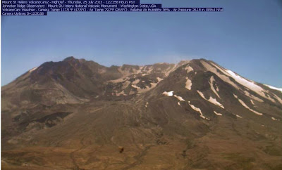
Take a look at the USGS "Volcano Cam" up at Mount St. Helens. This is a live camera that runs year round.  It is showing nearly 80 degrees up at Johnston Ridge.  That is worth the drive to see the mighty volcano that violently erupted 32 years ago. The devastation remains today.


Saturday, July 20, 2013

Want heat, go East young man, Go east

My eldest son will be attending Central Washington University this fall. I found myself in Ellensburg on Thursday for a college orientation at CWU. While the 'Couv' enjoyed temps in the upper seventies to low eighties (my station recorded 78), Ellensburg roasted in the desert dry oven with temps hovering close to 100 degrees. But hey, it's a dry heat, like that makes it OK ;) It was beautiful though with nary a cloud in the sky.

East Side of Cascades overlooking Yakima on the Way to Ellensburg


Thursday night the wife and I decided to head north to Lake Chelan. Temps were very warm up there as well. It was over 80 degrees at 10 PM. Friday we enjoyed a day at the winery and then closed out the trip with a roasty, toasty trip to Leavenworth for some German Chocolate.

The return trip over Snoqualmie pass yielded more typical 70's and 80's.  What a relief to be back on the west side with manageable summer weather that is a pure delight. Today should make it to the mid 70's which is fabulous. Get out there an soak up that summer my friends, soak it up.

Monday, July 15, 2013

This is get outside time!

This past weekend was spectacular. Saturday was mild with temps in the mid-seventies and Sunday warmed up to the mid-eighties. There was bright sunshine all around and wonderful outdoor opportunities. I took a ride over to Portland on Sunday to visit the Pittock Mansion. The view was awesome and the weather was perfect.

Our local weather professionals at the National Weather Service are indicating there will be a much of the same this week. I wrote more about the Pittock Mansion in my blog, The 'Couv' Life. Soak it up my friends, soak it up. 

Thursday, July 11, 2013

It just doesn't get any better than this.

This week has been nothing short of spectacular. It was a little toasty on Tuesday with my temp hitting the upper eighties but the rest of this week has been upper seventies and low eighties. That is probably the temperature in Heaven, my friends. Our wonderful 75 days of summer are in their early weeks and the proverbial goods have been delivered. We should get more of the same for this weekend. Soak it up.

Monday, July 8, 2013

Gloriously Perfect Summer Weather

Since the Fourth of July we have been bathed in that perfect summer weather I have been blathering on about for several months now. We tend to have some morning clouds that roll in an hour or two after sunrise and hang around till noon-ish. Then the grand magnificence of our home star provides mild warmth and temps in the mid seventies to very low eighties. How sweet it is. Soak it up my friends, soak it up.

Friday, July 5, 2013

What a glorious 4th of July

The weather was perfect. There was just a little bit of low clouds from mid morning till noon and then beautiful sunshine and upper 70's for Independence day. The breezes died down late in the day and allowed for perfect fireworks conditions in America's Vancouver.

It was all hot dogs and BBQ under blue skies and sunshine, followed by thunderous booms and flashes of brilliant color across a star filled evening sky. Fantastic!

Monday, July 1, 2013

June is in the books.

June Daily Temps
Welcome to July and the beginning of our 75 days of summer, here in the 'Couv'. June began quite warm, was mostly mundane and a little drippy in the middle then finished like a new furnace. What a ride! The numbers tell of a warmer than average June with less than average rainfall, but honestly, it felt like it rained more than that. There were a number of localized squalls that poured down like a spring waterfall at times. The squalls just missed the gauge, I guess.

June Daily Precipitation
My rain bucket had a mere 1.69 inches for the month nearly an inch off the average for June. Temps were just a touch above normal both overnight and daytime.

July has started off just like June ended with high temps and a little more moisture than typical for hot days in Southwest Washington. Relative humidity has been running around 50% with temps in the high 80s to mid 90s. That puts the heat index up near 100 at times. Toasty warm for sure.

Wettest day officially at my station was 0.38 inches on the 19th. The warmest day was the last day at 92.6 and the first 90 plus day of the year. I measured 89.9 on the 28th. The highest heat index came on the 30th as well with 97 degrees. (NOAA calculation 92.6, 44% humidity). Coolest evening low was 44.4. Every day broke sixty degrees. We had twenty days of sunshine and nine days with rain.

My location tends to run a tad cooler than the official weather stations in the area. Several areas were reporting heat index values over 100 degrees. Personally I can do without high heat and our summers tend to have very few days over 90. Sit back and relax for Independence Day should be a mild eighty-five-ish. Soak it up.

Sunday, June 30, 2013

The Heat is On

The National Weather Service has had us under a heat advisory for the last few days and it has been toasty. Temps have been in the upper eighties and low nineties. Today, tomorrow and Tuesday are supposed to be the hottest of the the week. NWS is suggesting the temps will be in the mid-nineties with heat indexes at or above the century mark. The heat index is a measure of atmospheric conditions that effect the way we feel heat. We still have some residual moisture in the air which adds to a muggy feeling. Our low elevation adds extra "weight" as well so we will feel every bit of a 100 degrees if the mercury meets 95. If you go up to the mountains where the air is thinner you may feel less heat even if the temperature is the same. Remember just because you "feel" less hot does not mean it IS less hot. Humidity typically amplifies the effects of heat as well. We have been running at relative humidity in the 45%-60% range which gives the air a little "stickiness". Stay hydrated and minimize direct sun exposure.

Look at that forecast for Independence Day, mid eighties, that is sweet.


Stay cool these next few days and enjoy our late sunshine. Temps will remain quite warm and comfortable during our very long Northwest summer twilight and into the midnight hours. We screamed for summer, now it is here, soak it my friends, soak it up.

Wednesday, June 26, 2013

Wild and Wet June will Flip a 180

With only 1.7 inches of rain in the bucket this month we are actually leaning towards a lower than average rainfall total for the month. Yet it somehow feels like it poured all month.  Perhaps it was the localized heavy squalls that dumped copious sums of water down upon us. Some of these may have missed the rain bucket. Maybe it has been this latest long stretch of mildly cool and cloudy weather late in June that has led to the damp perceptions.

All of that is about to change my friends.  The National Weather Service has issued a Weather Statement for the end of this week and into next week.  It's not for thunderstorms either.

"A STRONG UPPER LEVEL RIDGE OF HIGH PRESSURE WILL BUILD NORTH AND
WEST FROM ARIZONA AND UTAH THURSDAY AND FRIDAY...CAUSING
TEMPERATURES TO HEAT UP ACROSS MUCH OF THE WESTERN UNITED STATES.
NORTHWEST OREGON AND SOUTHWEST WASHINGTON WILL BE NO EXCEPTION...
WITH INLAND VALLEY HIGHS WARMING UP TO AROUND 80 DEGREES THURSDAY
AND PUSHING 90 DEGREES FRIDAY. HUMIDITY LEFT OVER FROM OUR RECENT
RAINS WILL MAKE IT FEEL MUGGIER THAN USUAL...AND NIGHTS WILL BE
SLOW TO COOL OFF."

So, all of you complainers that have been whining about the cool temps and wet conditions this is for you. Do not let me hear you moaning about how hot it is this weekend. Here is the NWS forecast...


Summer will arrive a few days early. We may see the first 90 degree mark of the year this week. Soak it up.

Friday, June 21, 2013

Summer is Here, Sort of.

The summer solstice arrived last night at 10:04 pm and that makes today the first full day of summer. The solstice is the official beginning of summer but here in the Northwest, especially west of the Cascade mountains we have to wait a few more weeks.

The sun, if only it were out today, would stay in the sky blazing like a midnight candle, for nearly sixteen hours.  Today has been a nice quiet day. Warm but cloudy with a high that tickled the 70 mark before settling in around 65 most of the afternoon.  I witnessed a few raindrops here and there but nay enough to wet the road.  The first day of summer feels like the 92nd day of spring.  Because it kind of is.


tomorrow looks to be a very summer-like day but look at that forecast friends.  Nothing quite says 94th, 95th and 96th day of spring quite like the late June shower session predicted above. That meme I posted a few days back is starting to really sink in.  The rain does get warmer.  

I have been promising a summer for the last several weeks and our 75 days of glory are not far away.  Get out tomorrow and soak up all 78 degrees of sunshine. Then cruise through the first part of next week with 70s and showers while we close out the last two weeks of our 110 day spring.
 

Monday, June 17, 2013

Thunderstorms are a Rumblin'

The Cascades have had quite a bit of thunderstorm activity over the last few days including some boomers in the metro area.  Some of these squalls are accompanied by copious sums of precipitation in the form of rain and hail.

My son and I we returning from Central Oregon on Father's Day and after glorious sunshine in Bend we found heavy rain in Sisters just a few miles away.  The sun returned just a few miles away in Redmond only to followed by a violent cloudburst at Warm Springs with lightning, thunder and a torrential deluge of rain.

Late spring Weather in the Northwest can be quite entertaining as the rainy season is coming to a close but not quite done.  The warmer temperatures associated with June can cause storms to be more robust.

Get outside and enjoy the weather, whatever the weather :)


Thursday, June 13, 2013

Tonight's grads may need an umbrella

The last few days have seen sporadic outbursts of drenching rain. Many Clark County high schools are holding grad ceremonies this week. The larger schools often must hold them outdoors. My son walks tonight with hundreds of Seniors from Heritage High School here in the 'Couv'. Thankfully, MacKenzie Stadium has covered seating for some 7000 people so I will be dry, but the grads are down on the field.

We are hardy up here in the Northwest. We don't pop an umbrella every time the sky drips, but these locally heavy showers have been producing rain at the rate of a couple inches an hour.  That is drenching to the bone my friends. The squalls tend to be brief but at those rates of rainfall even five minutes will make you feel like a drowned rat.

Let's hope the worst is behind us and all the grads can enjoy dry weather as the receive their high school diplomas this week.

Monday, June 10, 2013

A Brief Hiatus from Heaven

Our long run of fabulous summer-like weather will take a short recess this week as some customary June showers stroll through the neighborhood.  Fear not my friends, the summery goodness shall return for the weekend.  I love this funny meme, but really it doesn't apply so much once July arrives.  At least not here in the 'Couv'.

The National Weather service is showing showers in the forecast for the middle of this week and a return to fairer weather this weekend.  The temps should manage to make the middle 60s during the showers and I'd call that warmer rain, wouldn't you?  For those precipitation haters, I'll stay this; you really are on the home stretch, the checkered flag is waving frantically and the finish line is clear.  You will survive. Our seventy five days of summer, blessed by God Almighty himself is just a few weeks away.  You will soon find yourself bathed in mild warm sun with long lingering nights filled with twinkling stars.  No jacket required :)