Thursday, February 27, 2014

It's Snowtime... maybe.

How's that for a "grab ya" headline? This weekend the NWS has a winter weather special statement up for low elevation snow. This is not anything like the big event earlier this month. In fact this is likely to be a non-event. However, there is some cold arctic air in the nation's interior that the NWS says will "retrograde" back towards the West Coast and that coupled with moisture headed in could mean flurries of light snow showers here in the city. Confidence for metro area snow under 500 feet is still low however so worry not.


Soak it up my friends, soak it up.

Sunday, February 23, 2014

All quiet on the Southwestern Front

After a cold snowy start to February, the snowiest February since I started keeping records at this location 13 winters ago, Mild and typical late February weather has now prevailed. The NWS has a pretty quiet forecast for this upcoming week.


March is coming and it is a fickle month. Although it rarely get really "cold" in March it is a month that can still deliver snowfall and it also can deliver warm temps in the 70s. Who knows what's in store but one thing remains certain; we will find out soon.

Soak it up my friends, soak it up.

Monday, February 17, 2014

A Real 'Howler' Last Night

I am operating today after a night of nominal sleep. A big blustery storm rolled into the 'Couv' overnight bringing with it howling winds in the 50 plus MPH range and a good soaking rain. All night long the wind ripped through the trees and beat against the side of my house. The rain came down so hard at times it just pounded the windows.

The ground became so saturated that all the earthworms had to surface. I walked out of my front door this morning to find a dozen of those worms taking refuge on my porch.

The good news is, that temps are very mild in the fifties already. As I write this, the sun is playing peek-a-boo with us. We should have a wet and windy week that may be capped off with glorious sunshine in time for the weekend.


As always, soak it up my friends, soak it up.

Thursday, February 13, 2014

A Tickle of Spring

A tickle indeed; for spring is certainly fickle. But let us not forget that winter remains till the last of March has been crossed of the calender. Last week's blast of winter has nearly faded into the recesses of our memories. Sure the giant piles of plowed snow in the parking lots is a reminder that winter is still around. But quickly it is melting with these 50s on the thermometer and showers of rain.

The last little pile of snow that remains on my property has been reduced to just a few snowballs worth. Even with warm temps and rain a foot of snow will will leave little reminders of its week of dominance for quite some time.

Today was a nice day with light overcast and moments of sunshine. But tonight a big storm is headed in bring rain and wind here in the valleys and trainloads of fresh powder to the mountains.
Soak it up my friends; soak it up.


Sunday, February 9, 2014

Snowmageddan is over

The mercury pushed its way up past freezing today and the precipitation has stopped. This five year snow event is for the most part, over. The kiddies get one more day off from school to give the neighborhood streets a chance to clear up a bit. later this week it will be back to a normal mid winter cycle of chilly rain and occasional sunshine 'teasery'.

I am not saying that Old Man Winter is completely done. We may see a few flakes fly before the summer birds return, but I doubt we get more than a dusting or two.

This is the total snowfall from this event thus far. It is possible that we could see a little more snow or freezing rain tonight but I am doubtful that it will amount to anything much.

This will go down as my snowiest February since I started record keeping here in 2001. More than eleven inches of snow has fallen this month and it is only the 9th. Most of this came from the 6th through the 8th.

Temperatures during this event were well below average. The 6th was the chilliest afternoon with a high of just 22.2 and over 5 inches of very light and fluffy snow. The temps stayed in the teens and twenties until today when things began to warm up into the low thirties. After these larger snow events people often start comparing to other snow events over the years. The biggest snow event in the last 40 years was 1980 when Vancouver recorded 42 inches of snow in the month of January! Later that year the mighty Mount St. Helens had her historic eruption.

Here are the seasonal snowfall totals at my station for each of the last 13 winters and an annual average. This year is already a touch above average but no where near the monster seasons we had in '03-'04 and '08-'09. We got a legit shot at beating the 14.05 inches in '11-'12

Get out and enjoy this great winter weather. We only get these super snowy events every five years. Don't fret it, soak it up, my friends, soak it up.


Friday, February 7, 2014

We were due...the snow debt is paid.

Feb 6th, 2014 approx 3 PM
Every five years or so we get a significant snow storm. The kind like we got yesterday and that will continue today. When all is said and done just about everyone in the metro area will have at least 8 inches on the ground and some will have upwards of 2 feet. The last "big one" was Christmas 2008 just a month more than five years ago. Prior to that event was the snow and ice epic event in January of 2004 just a few weeks shy of five years earlier. Pattern? Perhaps.

Yesterday I received about 5-6 inches of snow. There was only about 4.5 measurable because the first few hours of snow came in sideways and drifted several blocks away. I will officially record 5 inches since I can't be certain how much blew off and ended up in that 18 inch drift down the street. I probably had 6 inches.

As I write this, there is a break in the cloud cover and that February sun is trying to exert some dominance over this snow. The temp is in the mid twenties now but I am sorry 'El Sol'; you don't have the amps to bust threw this cold air layer today. When the next low pressure system arrives it will pull cold air in through the gorge to fortify this as an all snow event. The National Weather Service has posted another Winter Storm Warning and they expect another 2-6 inches in the city and of course varying amounts in all the assorted neighborhoods. I would expect to at least match yesterday's totals here. If that pans out, I will have close to a foot on the ground and that really is a five year event.

My personal record snows are not likely to be broken but this could end up second or third. I have been keeping snow records at this location since 2001.

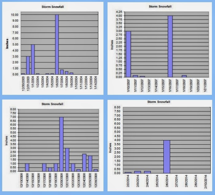
Here are the four occasions in which I had at least 5 inches on the ground since 2001. Yes only four. I have had 41 snow events with at least a trace sticking to the ground in those 13 winters and only a quad with 5 or more inches accumulating. The snowiest single day I recorded was January 6th, 2004 with 10 inches coming down on a day that still stands with the coldest daytime high reading of 20.8 degrees. I was just shy of 20 inches of snow from that event that ran from December 30, 2003 until the last of the freezing rain was done on January 9th, 2004. I had a maximum snow depth of just under 12 inches (a half inch of solid ice over the top). January, 2007 had a snowy and cold spell with 3 inches falling on the 10th some flurries through the week and 4 more inches on the 16th piled on most of the snow that was still hanging around to a depth of 6 inches. The biggest snow event I have had yet however, came on a rare white Christmas here in the 'Couv'. December 2008 was a wild and white month that began on the 13th. Most of the snowfall was light but there was a blast of 7 inches on the 20th. All totaled I had the deepest snow cover of my 13 winters here in NE Vancouver with a whopping 15 inches on the ground on Christmas Day and a storm total of over 19 inches. Since then snowfall has been the more typical for the west side of the Cascades; light amounts with wet and slushy conditions for the most part. Until now.

Yesterday the temps remained in the very low twenties and teens and the snow was mountain dry. Very ineffective for snowmen or snow balls. With my temperature expected to get up towards 30 degrees this next round will likely be a little more moist.

Our friends in the upper Mid-West will post tweets about us with RAOFLMAO at our shut-down the town attitude over less than a foot of snow. But what they fail to understand is that the 'Couv' is home to some 300,000 people and has fewer snow plows than a Mid-Western town of 30,000. Spokane, Washington is the urban snow king in the State of Washington, averaging 49 inches of fluffy white precipitation each year which is about the same as Minneapolis, MN. They have more than 60 snowplows and Spokane is roughly the same population as the 'Couv'. When Spokane gets a 6 inch snow event, they can easily plow the streets in a relatively prompt fashion. Vancouver has... wait for it... 8 plows. So I don't know about our larger neighbor to the south, but I understand Portland has a similar problem. So yes my friends SIX inches will shut down this town! It takes a much larger event to cause widespread problems in the upper Mid-West but when those areas reach the point that their snow removal is ineffective; lo and behold they look just as silly as we do.

We also don't use rock salt because of Columbia River environmental concerns, so the snow piles up and hard packs on the roads. The plows can only hit the main arterial roads. Neighborhood streets will thaw naturally before a truck ever finds its way down any suburban lane.

So stop laughing at us; these "big" snow events are not common enough to justify the expense of a major snow removal staff. However, note to Vancouver City Council, having a private force of snow removal people on call could be a solid idea. There are a lot of farmers with tractors that plow private shopping centers so why can't you hire those guys to hit the streets of the 'Couv' when these snowzilla events take shape? Yeah good idea, I know ;)

Enjoy our snowy extravaganza and by all means; Soak it up my friends, soak it up.


Wednesday, February 5, 2014

Cold and snowy...maybe.

The Dangerously Majestic, Mount St. Helens 2-5-2014
Today has been a gloriously beautiful day... if you are looking out the window of your warm car or office. The fantastic yellow orb is blazing away across a deep blue sky. It could be 70 degrees out there. Until you open the door. Temps are hovering in the mid 20s around the city with a very stiff wind coming out of the gorge. Wind chills this afternoon are teasing the 0 degrees Fahrenheit mark.

The NWS updated it's forecast today taking out the bitter cold temps and replacing them with a slightly warmer and snowier scenario beginning tomorrow.


How much snow? Well, it could be a little or it could be kind of allot. The second storm coming in on Saturday will have copious amounts of moisture but it will also have warmer air associated with it. The warm air will erode the cold air at the surface which provides for a transition from all snow to sleet, then ice and finally rain. How quickly that transition happens will have a huge impact on how much wintry precipitation we get. 

Hold on to your hats... this is gonna be a fun ride. Get out and enjoy this cold sunshine before the white fluffy stuff comes. Soak it up my friends, soak it up.

Saturday, February 1, 2014

A Big Bowl of Burr, is Headed our Way

January is done and temperatures were par for the course. It all averaged out to pretty close to normal. The average daily low was 33.88 just a tick above normal and the average daily high was 45.89 a little more than a degree on the warm side. The coldest temp was a chilly 22.8 on the 5th and the warmest was a balmy  55.2 on the 24th. We managed to get above freezing every day with the chilliest afternoon a foggy 37 on the 4th and the warmest overnight low came on the 10th with a toasty 46.2.

Once again rainfall was the topic of trouble. It was a well below average 3.78 inches in the bucket. We had 15 days with subfreezing lows and a whooping 8 days with the mercury buzzing around in the 50s. Only 10 days were rainy and 11 days were sunny. More sun than rain in January? Yep. You don't see that very often.

Nary a flake of snow was seen in the month on January down here in the city. Overall it was a ho hum winter month that never really got too cold and frankly it was nice more often than not. I have no complaints about that!

Things are going to change back to more wintry condition this week however. More of that wonderful arctic air is set to drop in over us. There will be some cold and dry days and possibly some cold and white, fluffy days. Tough call on snow this late. The mighty fireball manages to get up a little higher in the sky as we move closer to spring. That means it can do a better job of warming the air. So I doubt it will be single digit cold like it was in December but teens here at my station are not out of the question. It looks like a big bowl of burr, is headed our way.

Since I have been keeping records at this location I have not had much snow in February. In fact, I average quite a bit more in March. But the law of averages says February is due, so I say bring it on.