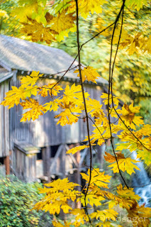
 The Autumn plunge is in full effect as temperatures shall continue the rapid descent towards winter. October had a mid-month touch of Indian summer, a rarity in these parts. The trees however tell the tale of Autumn and as those brilliantly colored leaves are now beginning to pile up all over the place. Temps will plunge further and struggle harder to breach the 60 mark and later next month the 50 mark will become a challenge. So it is with the fall.
That touch of Indian Summer I mentioned led to a personal daily record on the 16th. A late 80° mark and likely the last such temp until mid spring. That is the latest date I have recorded an eighty degree temp at this station. That was the only temp to breech the octo-range but several mid-month days were crisp and clear with lovely 70s.
The warmest day for October 2018 was that aforementioned 80.2° on the 16th and the warmest overnight low was the 1st when it dropped to a summerish 55.8°. The coldest temperature I recorded was 36.3° on the morning of the 15th. The chilliest daytime high came on the 5th at just 51.6° under rainy conditions. October gave us five days with highs at 70° or better including that lone eighty. 21 days busted out over 60°. October failed to deliver our first freeze which is not unusual, but it did manage a frost on the morning of the 15th. 8 overnight lows ended up under 40°.
Our average overnight low was actually a tad chillier than my station 'normal' but daytime highs were nearly 3° warmer than my 'normal'. That can be attributed to the mid month sunny stretch. Rainfall was the real tendency breaker. I only managed to get 2.52 inches in the bucket, well short of my "average" 4.15 inches. The soggiest day came on the 27th when 0.56 inches fell which was one of just five days at or above 0.25 inches. October is a transition month between the dry summer and the wet fall/winter/spring. November is here and it should be wetter and colder from here on out.
 Generally November is one of the two wettest months of the year. My "normal" for November is 7.98 inches just a tad less than my "normal" of 8.05 inches in December. In a typical winter pattern NW Oregon and SW Washington get the brunt of the systems coming in off the Pacific, as the winter settles in, often the jet stream takes a southerly dip sending some of the storms a little further south into Northern California. I'd love to see above average rain over these next two months since we are a very dry 17.87 inches year to date. Of course water years round these parts are are measured from October 1 through September 30. But none-the-less I'd like to see some moisture to end out the year. Even if I have average rain over the next two months, I'll end up with a sub-par year.
This year climatologists think El Niño conditions are building in the tropical Pacific. This means warmer ocean surface temps and often a stronger but more southerly storm track. If that holds up then Northern California may pick up a chunk of "our" rain. The southerly jet can sometimes leave an opening for incursions of Arctic air into our region.
If El Niño settles in, I think we end up with at least one significant arctic event over the winter. The last two winters have had above average snowfall, I'd say the odds are we under perform this year. So here we go, the snow season begins, November is not really much of a snow maker, we shall see what happens as the darkness descends over the lands north of the 45th parallel.
Soak it up my friends, soak it up.

No comments:
Post a Comment