Saturday, December 1, 2018
Last Month of the Year! Happy Holidays.
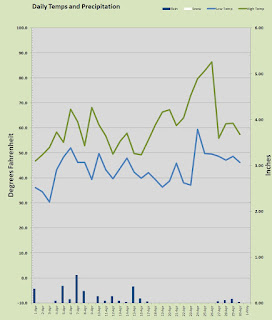
Well that was a rather uneventful November. November is typically one of two very wet months in the Southwest Washington and Northwest Oregon climate, yet this year November was a little on the dry side. November is usually the month I record my first hard freeze, and that did happen, despite the overall warmer than average temps.
The 11th month yielded a few notable events. The warmest day was the very first day of the month when the merc shot up to 64.9°. Both the first and second days of November were the warmest temps on those days, I have recorded at this location, however the all time records were not in jeopardy. The warmest overnight low of a balmy 55.9°, arrived on the morning of the 1st and likely contributed to that day being the warmest of month.
On the cold side of the thermometer, the chilliest temps was a 28.2° morning on the 11th, not cold enough to beat my daily low record but the 29.5° morning on the 19th did set my local daily low record. The coolest afternoon high was a 44.6° day on the 12th hardly any threat to a record there.
Overall last month delivered 5 subfreezing mornings, 14 mornings under 40°, 12 days above 50°, 10 days with sunshine, 9 rainy days, and no snow or ice aside from a few brief flakes mixing in with rain.
Now that rain was mentioned, only 3.2 inches landed in the bucket less than half my typical 7.98 inches. The soggiest day came on the 22nd when 2/3 of an inch fell one of only three days above 1/2 inch and six days at 1/4 inch or more.
Is this a precursor of the rainy season to come? Who knows? The science guys are still trying to determine if El Niño will settle in at all and if so how strong. El Niño tends to send a sizable chunk of our rain further south towards Northern California, good for them, not so much for us. These weather years can still bring cold winter weather down tot he valley floors but in general temps are a bit warmer than average under these conditions. Only time will tell for sure, but this wet season has started out a little dry.
December is here and with it the question about holiday snow. Here at my low elevation of just 267 feet, I have had just two Christmas Snow events with an inch or more of snow on the ground on Christmas Day. December 24th-25th, 2008 I had 2.25 and 2.0 inches of fresh snow respectively landing on top of a foot that was already on the ground. Then last Christmas out of nowhere came a dusting of 2 inches on Christmas Eve, followed by a few more flakes on Christmas Day. Ho, Ho, Ho, Christmas snow!
Odds are of course that it will be a green Christmas since snow events are not real common to begin with and then asking to have them randomly occur on Christmas is bit much to expect. Above 1000 feet the odds improve significantly and at 2000 feet it's almost a given.
May you holidays be filled with joy... and whether your Christmas be white or green, frosty or wet, be sure to soak it up, my friends, soak it up.
Thursday, November 1, 2018
November Hath Arrived!
The Autumn plunge is in full effect as temperatures shall continue the rapid descent towards winter. October had a mid-month touch of Indian summer, a rarity in these parts. The trees however tell the tale of Autumn and as those brilliantly colored leaves are now beginning to pile up all over the place. Temps will plunge further and struggle harder to breach the 60 mark and later next month the 50 mark will become a challenge. So it is with the fall.
That touch of Indian Summer I mentioned led to a personal daily record on the 16th. A late 80° mark and likely the last such temp until mid spring. That is the latest date I have recorded an eighty degree temp at this station. That was the only temp to breech the octo-range but several mid-month days were crisp and clear with lovely 70s.
The warmest day for October 2018 was that aforementioned 80.2° on the 16th and the warmest overnight low was the 1st when it dropped to a summerish 55.8°. The coldest temperature I recorded was 36.3° on the morning of the 15th. The chilliest daytime high came on the 5th at just 51.6° under rainy conditions. October gave us five days with highs at 70° or better including that lone eighty. 21 days busted out over 60°. October failed to deliver our first freeze which is not unusual, but it did manage a frost on the morning of the 15th. 8 overnight lows ended up under 40°.
Our average overnight low was actually a tad chillier than my station 'normal' but daytime highs were nearly 3° warmer than my 'normal'. That can be attributed to the mid month sunny stretch. Rainfall was the real tendency breaker. I only managed to get 2.52 inches in the bucket, well short of my "average" 4.15 inches. The soggiest day came on the 27th when 0.56 inches fell which was one of just five days at or above 0.25 inches. October is a transition month between the dry summer and the wet fall/winter/spring. November is here and it should be wetter and colder from here on out.
Generally November is one of the two wettest months of the year. My "normal" for November is 7.98 inches just a tad less than my "normal" of 8.05 inches in December. In a typical winter pattern NW Oregon and SW Washington get the brunt of the systems coming in off the Pacific, as the winter settles in, often the jet stream takes a southerly dip sending some of the storms a little further south into Northern California. I'd love to see above average rain over these next two months since we are a very dry 17.87 inches year to date. Of course water years round these parts are are measured from October 1 through September 30. But none-the-less I'd like to see some moisture to end out the year. Even if I have average rain over the next two months, I'll end up with a sub-par year.
This year climatologists think El Niño conditions are building in the tropical Pacific. This means warmer ocean surface temps and often a stronger but more southerly storm track. If that holds up then Northern California may pick up a chunk of "our" rain. The southerly jet can sometimes leave an opening for incursions of Arctic air into our region.
If El Niño settles in, I think we end up with at least one significant arctic event over the winter. The last two winters have had above average snowfall, I'd say the odds are we under perform this year. So here we go, the snow season begins, November is not really much of a snow maker, we shall see what happens as the darkness descends over the lands north of the 45th parallel.
Soak it up my friends, soak it up.
Monday, October 1, 2018
Welcome to October!
September is in the books and she was a bit on the cool side yet a little dry as well. Despite having 7 days with measurable precipitation, the rain gauge only collected a smidgen over an inch. I did manage to record one temp in the nineties to boost the YTD total to 18 tied for the most since I started records here in 2002. There is a 99.9% chance that 2018 will pass without a triple digit high temp as September's best was a mere 90.7° The month was notably cooler than my "normal" driven by a 2° under for the overnight lows. It seemed wetter than it was as the rain that fell was short and light for the most part. Despite a week of cloudy weather, I still managed to have 20 days with sunshine.
The thermometer stayed above 40 degrees for the entire month and I measure 6 days at or above 80° Every single day in September of 2018 managed to get above 60° as well. The warmest temp was the 90.7° on the 5th, the warmest overnight temp was a warm 59° on the 8th. The coolest mark came on the morning of the 24th with a crisp 42.1°. The chilliest afternoon was the 29th when the merc had to stop at 63.7°
Rainfall was 1.04 inches, well below my typical 2.47 inches. The bulk of it coming on two consecutive days of 0.31 and 0.35 inches the 11th and 12th. Those were the only days that managed to produce more then a quarter inch. Snow levels did come down during the rainy spell that added the first fresh layer of snow to Mount St. Helens, but the warm weather last week melted it right back off.
So now we are fully engaged with autumn and we begin our frost and freeze watch. When will it frost and when will it freeze? The trees are getting ready to put on the annual fall color show and that is always a delight. I typically get the first sub freezing low in the month of October, but there have been several Octobers that did not produce a freezing temp. A frost is inevitable in October. October is also capable of producing temps in the 90s but it is rather rare, in fact even 80s are an oddity for the Harvest Month.
October is a beautiful month weather she be cold or warm so get out and soak it up my friends, soak it up.
Saturday, September 1, 2018
The Autumn Segue Begins
August 2018 is history and it was a classic if not a tad warmer month. Looking at the chart here you can see several incursions above the 90 degree line. That brings my total for this year to 17 days at 90° or higher just one day shy of my record of 18 set in 2015 and 5 more than the average year which sees 12. In a typical September I will get one or two 90 marks at my house, but they almost always come in the first week of the month and we seem to be in a chilly mode right now with clouds, showers and temps in the 70s. We shall see, a pair of late 90s will topple my previous mark for days with wasted heat energy ;) Despite all these 90° days I have not posted a century buster yet with 97.3 my 2018 high thus far, posted in July. I have never recorded a 100 mark in September so 2018 will quite likely leave without one. That is not at all uncommon as I have roughly half of the years go by without a triple digit temperature.
August looked like a typical August really, average temps hovering just a smidgen above "normal" with a daily average low observed at 57.63° and high at 81.64° both just about one over. The hottest afternoon came on the 9th with "El Sol's" 94.6° effort. That was one of seven days in the nineties. The coolest daytime temp arrived on the 26th when the mercury was subdued to a mere 63°. The chilliest evening temp was the lone sub-fifty mark of 47.5° on the 25th. August gave us several warm evenings, producing nine morning lows in the sixties including a toasty 65.5° on the 10th. It's not surprising it followed the warmest daytime high on the 9th.
The month of August managed to give us 21 sunny or mostly sunny days and just 3 days with any "real" rain. Several of those "sunny days" were hazy with smoke from fires in Eastern Washington and British Columbia pushed into our region. I received some showery weather towards the end of the month producing a total of less than 1/4 inch well below the "normal" 1.27 inches for August, but still within the typical expectation for the month. The wettest day was the 26th with 0.09 inches.
So as the title suggests it is time for the Autumn segue. Even though the ninth month can and often does produce warm sunny weather, it has a a tendency to feel chilly as temps take a bit of a plunge. October and November are the months that really plunge on temps but this is a segue from warm and reliable summer weather to chillier and wetter fall weather. It is definitely time to have a backup plan for any scheduled outdoor activities if you don't like a little damp in your life. We are not likely to see any sub freezing lows nor are we likely to have a real heatwave. In fact with the exception of the increased threat of rain, September is usually a gorgeous month. Lovely 70s and low 80s are never out of style.
Soak it up my friends, soak it up.
Wednesday, August 1, 2018
Sizzling in the Summer
July is done and what a month. Great weather if not perhaps a tad heavy on the heat. I did not break the century mark but I did manage to bust out nearly a dozen days in the nineties and that's just about a whole year's worth in one month. July 2018 was almost completely dry and warmer than typical with a couple of days in the upper 90s.
The area saw mostly sunshine and warm temps with just two days exhibiting any precipitation all of which was isolated and very light.
It was a glorious July, a touch too warm for me perhaps, but well within the range of perfection for summertime.
Temps were in fact quite toasty with my station reporting a daily average high of 85.16° a full five degrees warmer than my 17 year "normal" of 80.20°. The overnight lows average in at 57.82° which is nearly two above my "normal". The hottest temperature I recorded last month was a 97.3° on the 29th which was one of two days at 97 plus the other was the 15th. The 97° mark on the 15th was a local daily record for my station. The warmest overnight low came on the evening following the first 97° day with a balmy 64° the morning of the 16th. I measured 11 days at or above 90° and all but two days managed to get above 70°. There was a rogue overnight low in the chilly 40s when the merc dipped to 46° on the 3rd, of course that was the only sub-fifty of the month. The coolest daytime high was the 2nd when I topped out at 67.8°. On both of the days I recorded 97° plus other local areas saw temps tickling the triple digits. Never trust those bank signs sitting in the sun, but the National Weather Service knows how to properly place equipment and they had at least a couple of 100° marks in and around the metro area.
There isn't much to report on the precipitation side of the equation. I measured a total of 0.09 inches. I had a misty drizzle on the 2nd of July and a brief thunderclap with a short rain on the 9th. That's all there is on rain folks, and I like me a good dry July. The "Dog Days" of summer should be free of any annoying sky water, right?
August is starting out a bit cooler than July ended and I don't mind at all after that toasty month in the rear view mirror. In fact, we may get some showery weather late this week or early next week and that will help wet the forests and repel some of that summer fire danger. A little bit of well timed rain can be a blessing, even in the summer.
On a rain note, we are running quite light this year on rain. Some may like that but I do not. This local eco-system benefits from the consistent rainfall and cloud cover so I'd love to see a nice soggy autumn this year. A little summer shower can take the edge of the fire danger as well. One need only look east of the Cascades or down south in southern Oregon and California to see how bad fires can be when things get too dry for too long.
The year to date rain chart sums up our lack of precip well.
Whatever you do rain or shine, hot of cold, be sure to soak it up my friends, soak it up.
Sunday, July 1, 2018
Hello Summer :)
The month of June has retired for 2018 and now summer is really here. Over the course of the next 75 days we shall enjoy the finest weather mother earth has to offer. We earn it every year.
Miss Spring was her typical self this June with some tears, hot flashes, and temper tantrums. Glad that's over, let the summer commence!
June was pretty typical actually with a near dead on average temps over the course of the month. I had an average daily low at 52.45° just a tiny tick above "normal" and the Highs came in at 72.43° also a tick above. Although normal is a collection of extremes as Pat Timm has always pointed out in his weather columns, we didn't have too many "extremes" last month.
The warmest day was the 24th when I read 87.6° one of only three days above 85° all month. The warmest overnight low came in on the 20th with a 61.9° and nearly matched again the next night. The chilliest temp came on the 12th with a 42.1° mark and there was one day that failed to reach 60° and that was the 10th with a very march like 55°.
June gave us 15 days that were mostly sunny and 8 days with some rain. I had several days with thunderstorms including a few short but heavy downpours. We got 4 days above 80° and 17 days above 70°.
Despite some serious downpours, all but one of them were too short to really do much to the rain gauge. The wettest day was the 9th with 0.55 inches and that was the only day above 0.25 inches. Despite the 8 "rainy" days I only managed to collect 1.37 inches of rain and that is another sub-par month. Just 13.99 inches in the bucket at the halfway point and that's a touch under HALF my rolling average.
We are in for a dangerous fire season so please be careful out there. We are about to enter the start of a 60 day period where it is not at all uncommon to have ZERO precipitation. I average about an inch of rain in each of the two summer months, but I have also recorded several July months and August months with no rain at all.
I wouldn't mind having a couple of days in both July and August with a quarter inch or more in the bucket, just to keep things greenish.
So there you have it, the start of the greatest summer on Earth so you drop the top, don the shorts and tanks, and go soak it up my friends, soak it up.
Friday, June 1, 2018
Hello June, how about some rain?
June the last month of spring and the herald of summer. It's here, it's live, it's right now. But the elephant in the room cannot be ignored. My rain bucket and every other rain gauge in the Portland Metro Area was bone dry last month. It was dry even by JULY standards! I measured a sparse 0.12 inches of precipitation all in scattered shower form. My 16 year average for May is 3.25 inches. Holy Arizona Batman, we're turning into a desert! Well this is the driest May in some 80 years. But the real story isn't just the anomalous May, but this whole year is well under average precipitation. Since the start of the year, I have accumulated 12.62 inches of precipitation including the water content of nearly 9 inches of snowfall. That is on HALF of the established normal for the first five months of the year. I am actually hoping for a soggy June. I didn't want to say the "D" word yet, but if June doesn't produce some above average rainfall, drought isn't far off.
I had 22 sunny or mostly sunny days, just ONE day with any "real" rain, the 10th had 0.07 inches, light showers at worst. We really need some rain my friends, and that is not something we generally have to ask for in these parts.
So was May filled with warm and hot days to compliment the desert dry conditions? Well... not really. There was the warmest day of the year thus far on May 14th when the merc popped out an 87.1° which was one of four 80 plus days. Nary a 90 in sight however. Both the average low and high temp came in about 3 degrees warmer than my 16 year average for May at 50.75° and 71.61° respectively. That is "warm" but there was no major heatwave or extended period of super warm temps. Other than the lack of water falling from the sky and the generally sunny conditions, this was a typical May with some cool days, some average days, and a few really warm days. I think the 3 degree pop was likely due to the outrageous amount of solar warming we got. May is typically a cloudy month with a couple of sunny days, this last month was Southern California sunny. It isn't much of a stretch to say that sunny days tend to warm up more than cloudy ones in late spring.
The warmest overnight low came in on the 24th with a July like low of 57° and the chilliest afternoon was May Day with a nippy 57.9° high. There was really only one morning that was genuinely chilly for late spring, May 2nd barely stayed out of the 30s with a 40.1° low reading. The last 30 days of the month all had no problem getting into the 60s. Nearly half of the month managed to stay above 50° all day and night.
So the outlook for June and Portland's Rose Festival seems to look good with mostly warm and dry conditions. I wouldn't count out a soaking rain sometime in June. We have a reputation to uphold here, and we need to temper the flow of Californians moving to region with some 'disturbing' late spring rainfall ;)
Friday, May 4, 2018
Hello May, What Have You for US?
May is a month that traditionally produces strong results in the local Real estate market. I wonder what she has in store for us this year? The MLS data still shows a rather slow production of new listings and the buyer pool seems to be about the same as last year maybe a little less as the rates are creeping up.
Many agents are hoping for more listings to appear, but be careful what you wish for. A few more would be nice but this market is more precariously perched than it may seem. The tight inventory makes it feel like it is a strong seller's market. In reality rising rates are biting into the buyer pool and a blitz of inventory could cause a flat line on pricing. We don't need that either. A continuing erosion in the buyer pool along with continued tight inventory should lead to more modest appreciation which is more healthy than giant gains in home prices.
I wouldn't mind seeing a tad more inventory as finding homes can be a nightmare. But watch the rates. They are still relatively low, but many buyers have been spoiled by a decade of crazy low rates and things are normalizing. Rates at 6% is a normal and typically healthy thing and we should be there in the next 12-18 months.
So hopefully May will bring us a slight perk in the inventory allowing those frustrated buyers a chance to find something. Sellers should be mindful of the potential for a price slowdown and cautious when considering offers. Sometimes the proverbial bird in your hand is really better than two in the bush.
I feel like May will produce roughly the same number of new listings as last year and the pool of buyers will get just a tad thinner. That should lead us closer to the scenario many analysts are predicting, modest price growth of 4-6% fro 2018.
Tuesday, May 1, 2018
April Showers and a heatwave!
April is in the books and not surprising, she was rather fickle and feisty. The month started out with a some chilly weather including lows below freezing and highs int eh middle 40s. That's chilly in April. But it didn't take long for Mr. Hyde to switch back to Dr. Jekyll and some nice spring weather presided over several days early in the month. Up and down and back and forth Miss Spring toyed with us in April. The showers we expect in April were a bit under the typical. Towards the end of the month Mr. Hyde emerged again and this time he was a bit 'hot' under the collar with the first 70° mark coming in at nearly eighty degrees and temperatures that would get into the middle to upper eighties.
On the thermometer we saw a seesaw of action. The coldest mark cam on the morning of April 3rd with a sub freezing 30.4° one of 11 days with lows in the 30s which is a bit many for this late in the year. The chilliest afternoon high was the day of the fool, April 1st when the mercury topped out at a nippy 46.8°. On the other end of the spectrum the warmest temperature was a toasty and very July-like 86.4° on the 26th. That hot day followed the first eighty plus mark of the year on the 25th when it was 82.9 and that followed the aforementioned first 70 when it was 79.7° on the 24th. The weird part was that the day after the scorcher only managed a high of 55.9°. What a quick departure from summer and back to "early" spring conditions. Average temps over the month were a tad above my 17 year average with 43.7° low and 60.84° high, 2 and 1 degree over respectively.
Nearly all of the month's rain came in the first half and only 2.8 inches hit the pan well shy of my typical 4.24 inches. Nary a flake of snow fell in the valley but there was quite a bit of low elevation snowfall for April with the local foothills getting several dustings over the month. The higher foothills such as Silver Star still have bits of winter clinging to the surface here in May. The wettest day was the 7th when I recorded 0.61 inches.
So far May is starting out rather cool and uneventful. The weather gang at NWS Portland seem to think some nice spring weather with highs in the low to mid 70s are coming up later this week. Springalicious!
Soak it up my friends, soak it up.
Sunday, April 1, 2018
Cool March Breezes Through the 'Couv'
Another month is in the books and March was on the cool side by nearly every measure. This winter season was a fickle one for sure. December was seasonably chilly with some snow on Christmas. It was followed by a downright warm January which in turn was followed by a rather snowy February and a seasonable March.
This past March was a bit chillier by night but spot on average by day. It was drier than average as well. Temps ranged from a low of 28.8° to a high of 69.8° these days coming on the 6th and 12th respectively. 2018 in Vancouver, WA remains without a 70° mark but some local areas did breech that barrier on the 11th and or 12th. The warmest overnight low was a 46° that arrived on the 13th; no surprise it followed the warmest day. The chilliest day time high came on the 24th with a winter-like 42.8° that cool afternoon followed a brief bout of snow in the morning. Overall the month of March was about 2° cooler than average by night and spot on by day. We saw five days with temperatures that fell below freezing overnight and two days which failed to get above 45°.
The rain gauge was certainly not overworked in March of 2018. I saw 2.89 inches which is well below my local 17 season average for March which is, 5.52 inches. The soggiest day arrived on the 17th with some scattered thunderstorms dropping a mere 0.55 inches. This was one of only five days over a quarter inch of precipitation.
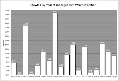
The tiny and rather fleeting bout of snowfall in the early morning on the 24th produced just a skimpy quarter inch dusting but it was enough to push the winter of 2017-18 into 6th snowiest season since I've been keeping records (2001-02). At this point it is unlikely any more measurable snow will fall this season, I have however had snow well into April, just not much and not at all often. The 2017-18 winter season will likely end where it is now with 10.95 inches of snowfall that was distributed across ten days, lying on the ground for 16 days, with a maximum depth of 3 inches.
April is probably going to deliver the first 70° temp of the year, but I'll remind you all that sometimes it takes all the way until May for that magic mark to occur. In the meantime as we wait for the 'real' spring to arrive let's just revel in the springtime, the flowers, the warmer temps Yes, soak it up my friends, soak it up.
Thursday, March 1, 2018
The Big Switcheroo!
Yes friends old man winter pulled a sneaky switcheroo on us this year. January and February seemingly switched positions. January was a warm month even by February standards with several daily highs broken, no snowfall and only a couple of days that dropped below the freezing mark. Kind of like February with wafts of spring. Then the real February showed up and within a few days it became clear the switcheroo was in play.
Although my average daily low temp for last month was still a bit warmer than an average for January it was close to spot on average for February. The average daily high last month was 3 degrees below my 17 season established "normal." The real switcheroo was the snowfall. I had a one inch dusting on the early am of Valentines Day that melted away in the afternoon and then some frisky cool air came in a few days later and I saw an inch on the 18th, a little dusting on the 19th and a bit of an on again off again 4 inch event on the 20th followed by two more days with an inch or more. 8.5 inches of snow in February is WAY above my 17 year average of 1.71 inches. In fact this is only the second February I have ever measured more than 6 inches for the month. 8.5 inches is second only to the crazy 11.1 plus we got back in February 2014.
I did have one daily record low on the 23rd when I awoke to a crisp 21.9 degrees. That was a record for me and for a number of areas around the metro. Early February has seen temps historically below zero with the record for the month at a Minnesota -3° back in 1950; but this late, the 23rd, 21.9° is legit chilly and it turned out to be the coldest temp of the month.
February seemed like a cold one with the above average snowfall, but the heavy cloud cover all month long actually kept things pretty warm, relatively speaking. Average low came in at 35.19° which is spot on my 17 year average and daily high average 46.69° well below my established norms. The warmest night was a toasty 47.8 on the 4th and the coldest daytime high was 33.8° on the 20th and it was accompanied by the 4 inches of snow. That day never had more than 3 inches on the ground as it snowed in two separate events about 2 inches in the morning, followed by mixed precip and some melt off, then another 2 inches later in the day. There were 8 days where the temperature managed to bust out over the top of 50° and we got close to a sixty when it was 58.8° on the 7th. We had seven days where the mercury could not push to 40° That turned out to be the week we had the snow and those low temps kept some snow on the ground for a week. The month ended with 9 days with a low below freezing and the aforementioned 7 days that failed to reach 40°
As for the precipitation it was cloudy but kind of dry really. Sure we had 8.5 inches of snow, but he water total in the bucket came in at only 2.07 inches and that is about a third of a typical February. We had 13 days with rain, 6 days with snow, but the wettest day was a paltry .36 inches. That was one of only three days to dump a 1/4 inch or more. We need more water down here and snow up there!
So March will once again be the wild card. Will it be an early spring or late winter? Today it is a bit of a tease as I am looking out the window to partly cloudy skies with peek-a-boo sunshine and a temp of 46.8° at 11:30am. Who knows, March can go either way. As it stands now this winter season is in a dead heat tie for 6th place on my annual snowfall chart with 2006-07 10.70 inches. Any amount of snow that falls before summer will knock 2006-07 into 7th. Over my 17 seasons of snowfall every February with 5 or more inches of snow has lead to a March with little or none. As it stands now I'd have to give the tie breaker to the 06-07 season as I had 19 days with measurable snow and a whopping 39 days with at least a trace of snow still on the ground. That crushes this season's totals of 9 days with measurable snow and 15 days with a trace or more on the ground. We only need a tickle to bump them, but it's just a silly snow chart, right?
Soak it up my friends, soak it up.
Thursday, February 1, 2018
Toasty Warm January, Kind of
What a month, we started off average enough with New Year's day delivering a 29.3° low on its way up to a rather typical 45.7°. The 2nd was pretty average as well with a chilly but seasonal 28 in the morning and rather January-like 41.7° high. The average start belied what lurked beneath the surface of this January that felt more like Northern California than SW Washington.
This month delivered 13 days with low temps above 40° and 10 afternoons that played in the fifties. But fifties were not all this month had on its mind, I pulled a 60.1° day under the warm rays of 'El Sol'. That 60.1° mark came on the 14th and was the warmest January 14th on record for me. Other areas around the metro picked up daily records as well. I had four personal daily record highs since my records began in 2002. The entire metro area had multiple daily high records last month. I broke 17 year dailies on the 6th with 49.8°, the 11th with 54.3°, the 13th with 58.8°, and the 14th with 60.1°. I got close to a record on the 28th when I hit 58.8 again falling short of the 59.5 best from a decade ago.
The warmest overnight low came on the 12th when we barely dropped under 50 with 47.3° evening. The coldest day was a rather normalish, 28° on the 2nd. We managed to get above 40° every single day last month. The chilliest day was the aforementioned Jan 2nd with a 41.7° high. Just three days dropped below freezing.
One might think that all that warm weather was accompanied by the 'Pineapple Express' rainfall. Yet no there wasn't any such express event. La Niña remained in control and rainfall at my house was well under my 17 year average, but not particularly "dry". 4.74 inches hit the bucket against an "normal" mark of 7.05 inches. The wettest day was the 24th with 0.61 inches and I recorded 6 days with a 1/4 inch or more. It was a mostly cloudy month, which is also typical for January. I had just a single sunny day with about 3 more partly sunny.
The real stat is the monthly average low of 39.01° which is a whopping 5° above my 17 year average. The daytime highs came in well above as well with a 48.88° about 4 degrees warmer than average.
So what of all this January warmth? Are we headed for an early spring? Or is winter prepping for a late run int he 4th quarter? You never really know about these matters. February 2014 was cold and snowy as was March of 2012. If the warmish weather continues past Valentines Day the odds of any severe winter weather begin to rapidly increase. As for that stupid groundhog, he's in Pennsylvania and we are in Washington. They are having a cold winter, we are having a mild one. Perhaps we are going to switch that around, or maybe we stay put. It all plays out over the next 6 weeks, the second half of winter, begins now.
Tuesday, January 2, 2018
Happy New Year!
Another year bites the dust and a new one begins. We had a relatively quiet end to the year but December was not without a surprise or two locally.
The biggest surprise was the White Christmas that most weather pros didn't see coming. The best the official prognosticators had was ice and sleet quickly turning to rain on Christmas eve. What we got in Portland and north was almost all snow and about 1-4 inches depending locale. I got a little over 2 inches at my house. The weather guys doubled down on warmer weather and mother nature kicked them in crotch with chillier than expected temps for a few days past Christmas which left the white stuff on the ground until warmer weather came on Thursday the 28th.
December had no real craziness however. No epic rain event, no heat wave and no deep freeze. The month was bone dry (for us at least) with just shy of three inches in the rain bucket against a typical eight inches. The Cascade snow pack is a bit thin this year and December is an important snow-packing month that really failed to deliver.
Warmest temp came on the 6th when it was a nice fall-like 57.6° the balmiest overnight temp came on the 29th when the merc stayed toasty at 47.1° under a pounding rain. The coldest morning was the 11th with a mark of 22.6° chilly but nowhere near any kind of significant cold. The chilliest daytime high came on the 24th when we failed to get above freezing with a 31.1° which led off a string of three days with low 30s for highs. Again nothing really cold, but chilly none-the-less.
Rainfall was weak sauce for December with 2.96 inches falling into the bucket and the soggiest day was a modest soaking of 0.59 inches on the 29th one of only two days with a half inch of rain or more.
2017 ended with 42.14 inches of rain the most falling in February with 9.41 inches. 10.7 inches of snow for the calendar year. The wettest day having 1.61 inches rain and snowiest day brought 5 inches. The coldest temp of 2017 was 13.3° the chilliest daytime high was 28°. The warmest temp was 103.6° and the warmest night was 67.3°. The year saw an average daily high of 61.26° and an average daily low of 43.78°. We had 54 days with a 1/4 inch or more of rain and 15 days with snow, sleet, or ice. We had 7 afternoons that failed to get above freezing and six days with temps below 20°. I recorded 14 days at or above 90° and three days in triple digits. 51 mornings fell below freezing, 167 days managed to bust out above 60°. 145 days were sunny or partly sunny and 128 days saw some rain or showers.
Overall 2017 was a pretty average year. It was the fourth coldest year for mean temp. A notable was the appearance of snow for Christmas. I have only measured snow on the 24th or 25th four times in the 17 years of record keeping at this location. Christmas Day 2007 I had flurries which briefly accumulated to maybe a half inch but melted within a couple hours. Christmas 2008 was the epic monster White Christmas with the 24th getting 2.25 inches followed by another 2 inches on Christmas Day this all on top on more than foot on the ground prior. Christmas Eve 2016 had some flurries and sleet that briefly stuck but it was barely measurable. Christmas eve 2017 with a nice 2 inches of snow that stuck around for few days.
New Year's Day was gorgeous with a crisp morning and brilliant sunshine all day long. Hello 2018 and Happy New Year to all.
The biggest surprise was the White Christmas that most weather pros didn't see coming. The best the official prognosticators had was ice and sleet quickly turning to rain on Christmas eve. What we got in Portland and north was almost all snow and about 1-4 inches depending locale. I got a little over 2 inches at my house. The weather guys doubled down on warmer weather and mother nature kicked them in crotch with chillier than expected temps for a few days past Christmas which left the white stuff on the ground until warmer weather came on Thursday the 28th.
December had no real craziness however. No epic rain event, no heat wave and no deep freeze. The month was bone dry (for us at least) with just shy of three inches in the rain bucket against a typical eight inches. The Cascade snow pack is a bit thin this year and December is an important snow-packing month that really failed to deliver.
Warmest temp came on the 6th when it was a nice fall-like 57.6° the balmiest overnight temp came on the 29th when the merc stayed toasty at 47.1° under a pounding rain. The coldest morning was the 11th with a mark of 22.6° chilly but nowhere near any kind of significant cold. The chilliest daytime high came on the 24th when we failed to get above freezing with a 31.1° which led off a string of three days with low 30s for highs. Again nothing really cold, but chilly none-the-less.
Rainfall was weak sauce for December with 2.96 inches falling into the bucket and the soggiest day was a modest soaking of 0.59 inches on the 29th one of only two days with a half inch of rain or more.
2017 ended with 42.14 inches of rain the most falling in February with 9.41 inches. 10.7 inches of snow for the calendar year. The wettest day having 1.61 inches rain and snowiest day brought 5 inches. The coldest temp of 2017 was 13.3° the chilliest daytime high was 28°. The warmest temp was 103.6° and the warmest night was 67.3°. The year saw an average daily high of 61.26° and an average daily low of 43.78°. We had 54 days with a 1/4 inch or more of rain and 15 days with snow, sleet, or ice. We had 7 afternoons that failed to get above freezing and six days with temps below 20°. I recorded 14 days at or above 90° and three days in triple digits. 51 mornings fell below freezing, 167 days managed to bust out above 60°. 145 days were sunny or partly sunny and 128 days saw some rain or showers.
December 24th, 2017 |
New Year's Day was gorgeous with a crisp morning and brilliant sunshine all day long. Hello 2018 and Happy New Year to all.
Labels:
2017,
rain,
snow,
temps,
year end weather stats
Subscribe to:
Posts (Atom)