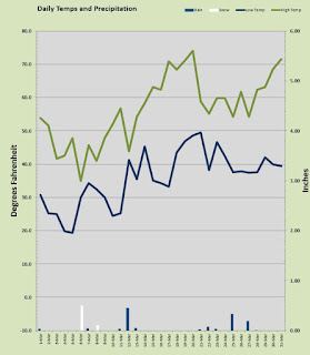
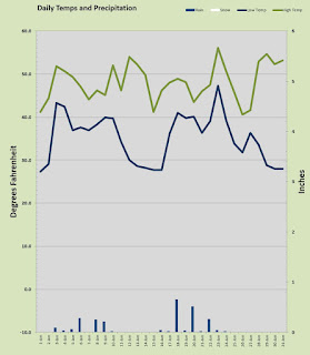
November is traditionally the wettest month of the year, but 2019 had other plans. I collected a measly 1.98 inches of rain in a month I usually see close to 8 inches. The last few years have been a bit dry so I wonder when that trend will reverse? November was a tad cooler overnight but a smidge warmer by day resulting in a slightly cooler than normal mean temp.
I mentioned in the title first snow and that is a bit of click bait. It did snow, but late in the evening just as midnight approached, flurries of snow began to fall. Only a tiny bit collected on the windshield of my car, barely enough to measure. The snow continued for an hour or so into this morning. By day break it was all gone.
Despite the rather mediocre weather last month did produce a few daily records. On the 5th and 7th lows of 31.1° and 32.7° were actually the chilliest I have recorded on those dates. On the morning of the 30th I recorded the coolest temp of the month, a genuinely crisp 20.8° but that fell well short of the daily record I posted back in 2015 of 16.1° and further off the all time November record for my station of 13.1°.
November also posted up a daily record high for my location when the mercury topped out at 62.8° on the 11th. The warmest mark of the month was the first day of the month when the temp hit 63°. Overall I had nine mornings below freezing, nine days failing to reaching 50°, five days busting into the 60s, nine days with rain, 5 sunny days, and a lot of clouds.
Precipitation was light with the wettest day a mere 0.39 inches. Four days managed to produce a 1/4 inch or more. The last few days of the month presented a weather pattern that is the classic setup for heavy snow and the dreaded ice storm, had it been the end of December rather than November. The system that spit out the flurries came form the south. Northern California got a healthy dose of the pineapple express dumping copious amounts rain on the lowlands and huge volumes of snow in the mountains. Some of that warm wet air migrated north into our region and as the low pressure moved in the winds through the gorge brought in cold interior air. Deeper into winter that scenario can yield devastating weather like it did back in 2003-2004 when a foot and a half of snow fell from New Year's eve to the first week of January, followed by a solid INCH of ice in the biggest ice storm in a generation. But thankfully, November tends to be a bit warmer in the interior than December and January. This time the warmer air aloft mixed in with the cooler surface air and the result was just some flurries and a tiny bit of ice.
Looking ahead the models seem to indicated a warming trend with showers of rain and some highs in the 50s to start of the last month of 2019.
Sunday, December 1, 2019
Friday, November 1, 2019
The Autumn Plunge has begun
October is in the books and it was a chilly one by 'normal' standards. My observed morning lows averaged almost 6 degrees under normal and daily highs were nearly 3 degrees under. We had an outbreak of early arctic air that led to a week of genuinely chilly mornings and that no doubt pushed the averages down. But honestly the whole month of October was pretty cool. There was not one single day in which the thermometer at my station was able to break through the 70° barrier. Along with the cooler temps was drier air with only about a third of normal precipitation falling. The last five days of the month had below freezing mornings and 4 of them were daily low records. Oddly the 27° mark on the morning of Halloween was three degrees warmer than the record at my station of 24° set back in 2006.
Overall the temps were cool and I had NINE daily record lows fall in October of 2019! That's nearly a third of the month with record lows! Despite the chilly morning temps, the all time record at my station for October was safe as that was the aforementioned 24° on Halloween, 2006. I did get a 24.1 on the 30th this year which was the coldest temp of the month and just a tenth off the all time mark. I even had a coldest daytime high all time record for the month of October when the merc only reached 45.5 on the 29th. The warmest temp was on the afternoon of the the 6th when we got oh so close to seventy with a mark of 69.4°. We had one warm overnight low of 50.4° on the 16th. October 2019 gave us seven days with morning lows below freezing, and more than half the month failed to reach 60°.
The rain bucket stayed pretty dry only catching 1.64 inches well below the typical 4.15 inches for October. Just 9 days with any rain and not a single day over 1/2 inch. There were just three days over a 1/4 inch. The soggiest day this October could muster was a 0.44 inch on the 17th.
So is this cold October a herald for what is to come this winter? It is hard to say, but I do remember a chilly October back in 2003 that led to a snow event in late November and and very cold and snowy January 2004. That 2003-04 winter is the second snowiest I have on record at this location with nearly two feet falling that season. We can only wonder what dastardly deeds Old Man winter has planned. I like snow, so bring it on ;)
Tuesday, October 1, 2019
A cool and wet September and a new Fall
Hello October! It really is Autumn now, seriously it's getting chilly. The Fall season of 2019 decided to make an early appearance this year with a wet and frankly cool September. Temps were well under average by day and due largely to extension cloud cover a bit above average by night. I don't know if this is a harbinger of what's to come this winter season but if it is, get your waterproof gear and some heavy sweaters it's gonna be nippy.
September was mild and daytime highs were well below the average with 69.85° against the 'normal' 73.63°. Overnight lows stayed a bit warm with several cloudy night trapping that warmer daytime air at the surface. The month averaged 54.77° overnight about 3 over. September managed to come and go without a single day in the 90s. The warmest day was the 5th with an 85.8° mark. Humidity was higher than typical and that really felt like a 90 plus day. That was also one of five days at or above 80° all of which occurred in the first half of the month. The latter half of September is generally the start of the 'Autumn slide' in temps and that was the case this year as well. The warmest overnight low came on the morning of the 1st with a rather balmy 64.6°.
But September wasn't about warmth this go round. In fact I had a few record cold temps for my locale. More than half the days failed to breech the 70° ceiling, two days failed to make 60° and the 29th topped out at a Thanksgiving-ish 49.6°. I had to go back and double check the daily log to make sure the station didn't go down in the afternoon for a few hours. It did not. The 29th had the coldest daytime high I have ever recorded in September, at this station dating to 2003. Earlier that morning recorded a daily low record of 43 but that was nowhere near a monthly record. I also had a daily record low on the last morning of the month with the chilliest day of the month at 35.4° still well off my all time monthly low of 34°. We had just six days of mostly sunshine and 15 days with rain.
After August was wetter than average yielding 1.58 inches of rain, September gave us October like numbers in the rain bucket with 4.07 inches. That is well above my 2.47 inch 17 year average for the month. We had a few squalls that produce thunder, lightning and hail along with some drenching rainfall. 1.01 inches fell on the 8th. We had six days produce a 1/4 inch or more. On the 28th a late afternoon thunderstorm produced a rapid 1/2 inch of rain and dumped nearly an inch of hail that stayed on the ground for half an hour. If this past month is a herald, holy cow things are going to get wild!
October may bring us some nice weather for a few days of Indian Summer, but I wouldn't count on it. The latest I have ever recorded an 80° high was October 16th and the 17th is the latest I have ever recorded a 75° high. The NWS is calling for a few nice days in the upper 60s and some sunshine, but also several days of rain. If we get to mid October without any summerish weather, that's all she wrote.
Get out and soak it up my friends, soak it up.
Sunday, September 1, 2019
August was a little warm, a little cool, a little wet, and excellent all around!
August gave us a little bit of everything as far as summer weather goes. In the end it was a typical month with average daily highs spot on the 17 year normal for my station and over night lows a touch warmer than 'normal'. This was the first month all year to produce more than average rainfall but if we're honest, we need an above average month in the wet season not summer. But they way things have been thus far, I'll take the rain whenever we can get it.
August was not hot this time round. I had 3 days that popped up over the 90° mark to bring the total for the season thus far at just 6. That is about half a typical year, but September can bring some heat, particularly in the first two weeks. Another ninety or two is possible. August was pleasant, seriously pleasant. Every day except one made it above 70° and the one lone "cool" day was 69.6° so that's more or less seventy, right? The temperature never dropped below 50°, the chilliest morning was the 23rd with a 50.7°. Only 6 nights were under 55°. We had 10 overnight lows at or above 60° so this was an evening lovers dream month. The warmest overnight low came on the 2nd when it bottomed out at 64°. The coldest afternoon high of 69.6° arrived on the 21st along with some showery disturbances. The hottest day was the 28th when the merc topped out at 96.4° breaking a daily record at my location. It was one of two daily record highs for my locale the other was 95.5° the day before. August delivered 22 mostly sunny days and only 5 days with any precipitation at all.
Precipitation? But I wrote that we were above average, didn't I? Yes, yes we were in fact. I measured 1.58" in the pail and that is about a 1/2 inch over the established August "normal." Most of that rain fell during two heavy thunderstorms that rumbled through the area. The biggest one dropped 0.88 inch at my house on the 10th of the month, the other dropped 0.40 over night with 0.29 coming on the 29th and 0.11 in the wee hours of the 30th. There was a showery day on the 21st where I picked up 0.18 and the rest of the month was dry save for a sprinkle or two.
It was genuinely pleasant this past month. I do not like hot weather and we only had a couple of hot days. I prefer it to be dry in the summer, but we had a few short lived thunderstorms to wet the dry foliage, so that may help us in these last few weeks of fire season.
Hopefully we will have a nice wet fall to pad the weak rainfall numbers. We won't know until November and December but some nice soggy weather is long overdue round these parts.
Soak it up my friends, soak it up.
Thursday, August 8, 2019
July is done and it was a fairly boring month. Seriously nothing weather worthy really happened. No heat wave, not crazy rainstorm, no rogue tornado, nothing. The last several summers have been a bit on the warm side but not this one my friends. 2019 thus far has been pretty old school normal.
July was no exception as the merc at my station only broke the 90° mark one time! Yes just a single ninety for the month of July. The month featured 24 deliciously sunny days many of those having some morning clouds to start. Temps were under my established norms some 2 degrees cooler in fact by days with a average high of just 78.13° against my 18 year "normal" of 80.06°. Overnight lows were a bit warmer than average with 57.22° about a degree warmer and that could be attributed to the extra cloud cover in the early AM hours. There were just two evenings with temps below 50° and that's typical as July tends to be the warmest month. The highest temp recorded was a wimpy 90.5° on the 26th and that was followed by the warmest overnight low on the 27th at 63.9°. There were four days that failed to make it to 70° but 13 popped up above 80°. The chillest overnight low was a comfortable 49.6° on the 20th.
The rain gauge recorded yet another sub-par performance. In all fairness July and August are often below normal rainfall as the summer averages are skewed by monster thunderstorm events that occur every 5 years or so. July is often rain free but every now and then we get a 3-4 inch rain event in July and that throws off the average. I'm far more concerned about our sub-par winter months than these under average summers. That said, the most rain was on the 9th when 0.15 inches hit my bucket. There were only 2 days over 0.03 inches and a total of just 6 days with any precipitation at all.
So far this year just four days above 90° and that is well off a typical pace. There were two in June, One last month and another this month. We still have a lot of August to go and the first half of September can produce some scorchers as well, but my gut says we are headed for fewer than ten 90° days this year.
We are -17.43 inches for rain this year. Just 12.04 inches in the gauge thus far. We will need a hyper wet fall to catch that up.
So there it is July was bland but beautiful and we eagerly await what August shall bring.
Monday, July 1, 2019
Hot and Cold June
Another month down, we now sit halfway through 2019. June played a pretty good June this time round. I had some clouds, some sun, some rain, some hail, a couple of scorchers and a few genuinely chilly moments. That's Miss Spring's classic Northwest exit.
June was a tad on the warm side a couple of degrees up on light side and about normal for overnight. The hottest temp came on the 12th when the merc capped out at 98.8° one of two back to back 90 plus days both were daily records for me. The chilliest afternoon was also the only day that failed to reach 60° when it topped out at just 58.8° on the 27th. We had 9 days with overnight lows in the 40s, that's a fair bit for June and the coolest a 44.2° measured on the morning of the 9th and that was one of two mornings under 45° We did have one toasty overnight low when the merc stayed above 65° all night long. No surprise it cam after the 95.7° afternoon on the 11th and lead to the hottest day of the month on the 12th with that 98.8° I mentioned above.
The rain bucket was once again super dry. I typically see a couple of inches in the 'ole bucket in June this time just a paltry 0.89" We did have a pretty spectacular thunderstorm on the night of the 26th, power was out the whole nine-yards. That little monster dumped nearly half the months rain total in just a couple hours. Yet despite the theatrics, it was still only 0.41 in my gauge, so not enough. This is kind of serious, I am 16.75" off my typical rain figures through the first 6 months of 2019. That is only 11.70" of a 'normal' 28.45" and that's just 41% of normal. At this rate we are going to lose our reputation for deliriously damp and wonderfully wet.
All in all that was a nice June, just 4 days with any showers or rain and 21 days of mostly sunshine. July is looking like nice weather ahead and the 4th ought to be sunny and about average somewhere near 80°
It's time for the magical 75 days of summer in the Portland-Vancouver Metro Area :)
Saturday, June 1, 2019
May you fickle May, June you Fickle June!
So there goes yet another DRY month. I can't remember the last time I recorded a month with at least average precipitation. So I had to look it up. It was February and March of 2017 when 9.41 inches and 7.45 inches respectively fell into my rain gauge. Some of that fell in the form of snow (.55 inches snow). Since then it has been dry, dry, and a little bit dry.
At some point our weather pattern should return to the soggy days of old. Temps have been on the up trend as well and last month was no exception. My local temps were about 2° above my established "norms" both overnight and daytime highs.
Honestly this last month did not feel "warmer" than average. I think the mini heat-wave near the start of the month skewed the averages, because there was a fair amount of cloud cover and a great deal of typical May weather last month.
As far as temps go, I recorded two days that were personal daily records, May 9-10, when I recorded 85.8° and 89.2° respectively. These were two of the four days that topped out above 80°. The 89.2° mark on the 10th was the high for the month, well short of my May record of 95.3° set back in 2008. The warmest overnight low arrived on the 27th. The coldest temp was measured on the first day of the month with a nippy 37.6°, one of two mornings to dip into the thirties. The chilliest daytime high was a cool 54.7° on the 25th which was a rather damp day. All told there were 15 days with overnight temps under 50° and 26 days that were above 60°.
On the precipitation side of the equation it was in a word, dry. We had 15 days with mostly sunshine and 6 days with some rain. The wettest day was a modest 0.51 inches on the 19th which was one of only two days to spill more than a 1/4 inch.
May and June often struggle to find their weather place. These two months can deliver genuine summer type heat waves as well as chilly temps nearly reminiscent of winter. We never really know what these two months will bring so we must be prepared for anything. This year June has decided to start off with a taste of summer. As I wrap this article up it is 1:30 and the temp is at 76° probably on its way to an 80° or so late this afternoon. Ah yes, delightful :) But don't let Miss Spring get into your head, our local neighbor, Portland, OR has a Rose Festival to run; and it just wouldn't be a Rose Festival without some cool and damp weather. Miss Spring will likely oblige.
Soak it up my friends, soak it up.
Wednesday, May 1, 2019
April Showers Bring...Bland?
April is done and it was a bit bland. We did have those ever so necessary April Showers, but not like we normally get. We continued this extended run of dry months. There were no temperature surprises; just a couple of nice days, and one pretty nippy morning for April.
The rain bucket was well under my established normal of 4.24 inches with a barely over half of average, 2.28 inches. I measured 4 days with a 1/4 inch or more rain the wettest day being the 7th with 0.41 inch. 11 days with some precip and 7 days of mostly sunshine. No snowfall last month and that is typical for April.
Temps were slightly above average by day rough +1 and a bit toasty by night at +3. The warmest day was the 18th when the merc busted out a 75.4° the chilliest daytime high come on the 13th when the thermometer failed to reach 50° topping out at 49.8°. The coldest overnight low was a chilly 33.6 on the morn of the 28th. That's a bit late for a frost event, but there it was. The warmest overnight was the 57.7° on the 1st and that is no foolin' 8 days dipped into the thirties overnight while four days popped up above 70°.
That was a quiet April and now we move into the sweet spot for spring. Sure May can be wet, but it is rarely cold, so the second half of spring is ready to rock so get ready for some great weather.
Soak it up my friends, soak it up.
Monday, April 1, 2019
March Madness is not just for Hoops
What a crazy weather ride March 2019 gave us here in America's Vancouver. The coldest morning temp of the year arrived in MARCH. What? Yes a pair of back to back sub 20° mornings in fact one of which was low enough to lead the year, yikes. We had it all in March in fact the very first 60°, the very first 70° and the coldest day too. Crazy, we had some snow, some rain, some sunshine, wind, sleet, hail, lightning. It was truly a cornucopia of weather events.
Look at that chart! The first week of the month could have been a random January week. On March 6th the daytime high was only 34.9° for heaven's sake. The only real downside other than a bit chillier than average was the pitiful rainfall totals of just 1.26 inches for the whole month! That is desert dry my friends. We need some rain, seriously we should be around 18 inches thus far and I only have 7 inches in the bucket.
The temps were chilly the first half of the month and then almost on queue, springtime arrived right about St. Patrick's Day! I recorded nine days with temps below freezing which is a lot for March. 2 days dipped below 20° which is crazy for the third month. The coldest temp was a 19.4° mark on the morning of the 5th. The chilliest daytime high was the aforementioned 34.9 occurring on the 6th of the month along with a light dusting of snow. Things started looking up on the 15th when I recorded the first 60° mark of the year and two days later the first 70° arrived. March gave us a bunch of January weather, but also managed to spit out 11 days above 60° and four above 70° The warmest temp was recorded on the 20th the first day of spring, when the merc went to 74.1° The warmest overnight low came on the 21st at 49.5° The averages for the month were colder overnight and warmer by day.
On the wet side of things it was, well it wasn't actually. The previously referred number of 1.26 inches is dry, dry, and dry. The wettest day a damp but not soaking wet 0.45 inches and that was one of only two days to produce more than a quarter inch of rain. The snowfall was light with sticking snow on one day only about a half inch with only half of it staying on the ground for any length of time. The second snowfall was flurries only nothing stuck. Just 6 days with measurable rainfall in March and that is nuts.
April is here and with it the chance of any winter weather is down into the low single digit percentages. Spring has sprung, the flowers are in bloom and the weather will start down the long path towards summer. There is still a substantial amount of snow lingering on the foothills up in the 2000 foot range and that means there is a strong probability of frost for the next several weeks. Be mindful gardeners!
So don't forget to get outside and soak up the springtime, yes soak it up my friends, soak it up.
Friday, March 1, 2019
January was Late this Year!
Last month was actually February, we all know that, well all of us except 'Old Man Winter'. February 2019 was the coldest I have on record, yet it did not have any real cold weather. It played out a lot like a typical January even slighter cooler than average for that month.
February started out looking very February-ish with the first two days the warmest of the month the 51.6° mark on the 2nd would stand as the ONLY temperature at or above fifty all month. I have had a few arctic outbreaks over the years in February, but this wasn't really that. The coldest morning came in at 19.9° on the 7th which is chilly for February but not anywhere near my 18 year low for February which stands at 14.7° nor close to the all time record of -2°. Every day managed to get above freezing so my 18 year low maximum temp for the month was never even remotely in jeopardy as that stands at a nippy 22.2°.
Last month wasn't really about extremes at all. It was just chilly all month long. In fact all but one night dropped below 40°, 16 days fell below freezing, and 11 days failed to reach 40° at all. We had no signs of spring, just a lingering chilliness that never ventured too far towards "cold" but other than the 2nd day of the month, never got anywhere near "warm" either. It was the third snowiest February of my 18 years of records, but February has been the snow-maker over the last 5 years actually.
On the mercury side of the stats, the other notable temps were the warmest overnight low of 43° on the 2nd which lead to that solo 50 plus later that day. That was also the only day that stayed above 40° all day and night. The chilliest afternoon was the 35.4° recorded for the 5th. That featured flurries all day long that managed to accumulate to about one inch.
On the precipitation side of things, this is the month that could have been the snowiest February on my records and even had the potential for an all time record. But two things happened ever so slightly that kept that from happening. The first snow-making system that came through was very light just an inch, then the second system came through that delivered more than 5 inches and could have been huge, except the storm tracked north. This was one of those counter-clockwise rotation deals and Seattle got the brunt of it. A near miss for us. The third system came through and just clipped us providing little more than flurries with almost no accumulation. That storm hit Eugene Oregon 100 miles to the south head on dumping 6-12 inches on that area. Another near miss for us. We very easily could have had a 18-24 inch snow month, but alas, we did not. February 2019 will have to settle for the Bronze. We did have some rain including 4 days with more than a quarter inch the most came on the 12th when nearly an inch fell at 0.91 inch.
February delivered 7.5 inches of snow which is almost all the snow for the whole season. We shall see what March brings. March can go either way round these parts so I wouldn't count winter out yet. Today is bright sunshine and bold blue sky which should persist over the next few days. The coldish air remains in place for now however, and that means spring may have to wait.
Friday, February 1, 2019
First Month of Year rather dull
Welcome to 2019! The first month of the year came in about 1-3 up over "normal" on both ends of the day. I had no real snow just a flurry or two on the 6th. Snowfall has been at a severe premium this season.Precipitation in general has been running well below established norms.
This opening month to 2019 was pretty uneventful. No deep freeze, no major run dump, no snow other than a little flurry, no record breaking warmth, nothing really. Just 11 days with morning lows below freezing, but everyday managed to get above freezing. The mercury just stayed between 27° and 56° all month.
January 2019 saw the coldest temperature at a modest 27.3° on the morning of New Year's Day, one of those aforementioned 11 sub freezing mornings. Every single day last month managed to bust up over 40° with the chilliest daytime high a 40.6° mark that came on the 26th. On the warmer side of the spectrum we managed to see 11 days with the mercury topping out above 50° the warmest of which was a toasty 56.1° on the 23rd. Not a single night stayed above 50° the warmest overnight low was the 47.3° that occurred on the 23rd, not surprisingly the same day as the warmest high. January gave us 14 days with sunshine and just 10 days with rain, and technically one day with snow, but it was just a flurry and nothing stuck.
Precipitation was dry, again. We really need some rainfall and snow pack this year, holy cow. There were only 5 days last month that managed to spill more than a 1/4 inch of rain and the most came on the 18th with 0.65 inch. The 6th had a light and brief snow flurry I unofficially estimated at a 0.10 inch equivalent. Just 2.53 inches in the rain bucket which is less than half my 17 year average for January.
It is weird looking up at Silver Star in January and seeing such a light spattering of snow. This weekend starting on Super Bowl Sunday things might just whiten up a bit all the way down to the valley floors. If not to the valley, certainly below 1000 feet and that means the foothills will look proper again for this time of year. Ski resorts in the Cascades will certainly welcome more snowfall it has been dismal this season thus far.
The local weather prognosticators don't seem to know how big a shot we will get of colder arctic air. Most of the computer models seem to suggest it will be a mild shot thus the iffy stance on valley snow. One thing for sure is that we should see significant accumulations up higher in the 1000 foot plus areas. Right now it is raining and snow levels are pretty high like 5000 feet! Those levels will plunge as the weekend progresses. So it seems that winter may arrive late this year, we shall see.
Whatever the weather soak it up my friends, soak it up.
Tuesday, January 1, 2019
Happy New Year!
2018 is in the books and in a single weather word, it was... DRY. Not just dryer than average, bone dry semi-desert dry. But Rod, you live in Western Washington, how dry could it be? How about a paltry 25.32 inches of rain in the calendar year 2018. Yes precipitation years are measured like school years so we are only a couple of month's into the 2018-19 water year., but none-the-less 2018 was semi-arid and that total is barely better than half my 17 year average for precipitation.
While on the subject of precipitation, December ended up with a dry 4.25 inches of rain and just a spattering of snowfall that came in a light wintry mix on the 9th. That is barely over half my typical December rainfall number. The soggiest day delivered nearly an inch of rain, that came on the 18th with 0.95 inch. We had a total of 15 days with some rain and 7 days with sunshine. Nearly half of the wet days produced a quarter inch or more.
On the temperature front, the month was toasty warm compared to a "normal" December. Month 12 only produced 7 subfreezing lows and every day managed to get above the freezing mark. In fact, all but 2 days pushed the merc above 40 degrees. Despite the month being some 3 degrees warmer by day and night than average, there were no real warm days. The warmest temp I measured was a nice 56.5° on the 18th but that came with all that rain. The warmest overnight low was 45.5° also on the 18th. That was some pineapple express happening there. The coldest morning low arrived on the 6th with a 23.2°, nowhere near any kind of record but it was the chilliest December 6th since 2005. The coldest daytime high was closer to a typical high measuring 39.6° on the 9th.
Looking ahead to the rest of the winter, we are not looking good on snowfall, rainfall, and temps are running warmer by more than just a little bit. Things can change quickly and we have yet to have an outbreak of arctic air. I would expect at least one bout with a cold air mass dipping south into the Pacific Northwest and odds are some sticking snow will arrive during the next 6 weeks.
In the mean time, Happy New Year and hello 2019. Let's all continue to soak it up, my friends, soak it up.
Subscribe to:
Posts (Atom)